Monday, July 26, 2010

Out come the snakes

I drove out to Superior again on Sunday afternoon. I turned south on 177 when I got to town. I was going to look for a road that seems to go up to the Oak Flat area from 177. There's a long, boring story about why it might be hard to find that I'll tell some other time. I figured I would also check out any other side roads out there.


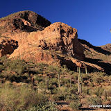
Storm clouds over Apache Leap. It's like the storms were in the same places as when I left the day before.

On the second or third road that I turned down, I came around a corner and there was a deer in the road right in front of me. It ran behind a bush beside the road. It didn't run out the other side. I looked behind the bush and it wasn't there. Those deer are slippery critters. A little further down the road I saw a road runner. It disappeared before I could get the camera out. The rattlesnake laying across the road wasn't as fast though.


The rattlesnake didn't run away. Snicker. It didn't slither away at first, either. It may have frozen to try to go unnoticed.

Here's a perfect example of why I wanted a camera that will also make videos. The snake put on quite a performance for the camera. Keep in mind that I have quite a bit of zoom. I wasn't nearly as close as the pictures and video make it seem. I'm not afraid of snakes, but I have a healthy respect for the poisonous ones. It would be foolish to put yourself close enough to one of these that it could take a strike at you.


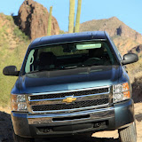
At one point I was driving down Battle Axe road (the road to White Canyon). It had lots of little gullies across it from the rain. There were also sticks laying across it. So there were lots of things across the road that I didn't really need to pay much attention to. Instead, I was looking ahead at the cliffs near White Canyon. Then I noticed the black and white stripes around one of the things in the road. I slammed on the brakes but it was too late. I went over its tail. I felt really bad. I guess if one ever bites me I won't feel so bad about running over a rattlesnake, but they have their place in the scheme of things and they're pretty animals. Maybe it'll survive and bite somebody because it doesn't have a rattle to warn them. Gee, I hope not. I continued down that road for a while and decided I had better get out before the road got slippery. Rain was moving in.


I thought I might get some really cool pictures of sun's rays, but I just got some so-so pictures.


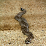
Third rattler of the day.

On the way back to pavement, I came across the third rattler of the day. There must be something about the cooler weather or the wet weather that has them out and about in the middle of the day. As with the other two, it was stock still in the road. I got out to take pictures and got close enough to get it stirred up. They will ignore pickups until they get run over but they don't want people getting too close. This one rattled as it backed away.


Once it got to the bushes at the side of the road, it quit rattling and hurried away. Then, in the quiet, I heard the other sound. The ominous crackling of high voltage power lines. I turned around and there they were, right behind me. They're following me around! I looked down at the road. Yes, it was still damp from the last shower. I hurried back to the truck and got out of there.


The scary part.

Click below to see all of the pictures.

2010_07_25

Sunday, July 25, 2010

Escaping the heat, again

It was only 104 when I left the house this afternoon. In may or June, that would be decent hiking weather. The dew point was up around 60 today, though. The body can't get rid of heat very effectively when the humidity is that high. Doing strenuous things in the sun miles from anybody that might notice you getting loopy would be dangerous. I hurt my knee yesterday and wasn't planning to do anything strenuous, but you never know. I went out near Oak Flat (east of Superior) again.

Since my knee was kind of achy, I thought that I might spend the day exploring roads out there. I started out on N Cerro Rd. There is a power substation out there and the road is almost paved out to the substation. I wanted to get some pictures of the substation but all that electricity makes me nervous. I saw a cactus I've never seen before right next to the substation. I rolled down the window to take pictures.


I've never seen one of these before. It looks sort of like a fishhook pincushion with barrel cactus flowers.

I took a wrong turn on the other side of the substation and the road got very rough. After going up a really bouncy stretch, I stopped and got out to take a few pictures and relax. I was still pretty close to the substation and could hear the 60 Hertz hum. I could also hear the high voltage crackling around the power lines. That's an unnerving sound. I needed to get rid of a bunch of water I had drank before leaving the house, but I wasn't about to put a conductive path between my vital organs and the ground so close to that substation. No circuit path for current to flow, you say? Then perhaps you will demonstrate how safe it is. High voltage doesn't give a hoot about open circuits. I headed back to the other side of 60.


The substation is hidden by the hill on the left. It's getting cloudy.

I was thinking about hiking out to a different part of Apache Leap. I thought I could see a faint trail on Google Earth. It would have been a long hike, though. Probably too much for my knee. Also, the clouds were getting bigger and darker. I kept driving until I was almost to the spot I had parked last weekend. I didn't want to drive that last quarter mile. I found a place to park and thought I might be able to get to the bottom of the canyon I was looking at last weekend without too much trouble from where I parked. With the clouds moving in, it had cooled down to about 90. I wandered slowly along a wash enjoying the scenery. Sweat trickled down my temples. It was so humid, I worked up a sweat by swatting at the occasional gnat. Well, I guess I always sweat out there. It just couldn't evaporate now.


I took mostly HDRIs out there, but I must not have had a wide enough exposure range. The clouds are still washed out.


Because of the clouds, most of the pictures I took were HDRIs. I felt strangely stable while trying to stand still for the three exposures. Maybe it's because I was standing in sand, or maybe because the wind wasn't blowing me around, or maybe it's because a couple of weeks ago I decided to cut down to one cup of coffee a day.


I bet this looks cool with lots of water flowing through it.

Not long after I left the truck, I heard thunder rumbling in the distance. It kept getting louder as dark clouds moved in from the north. I didn't want to walk very far anyway, so that was a good excuse to turn around. I tried to make a short video to record the sound of the thunder but the breeze blowing across the mike was louder than the thunder.


I saw a couple of cool looking lizards but they wouldn't pose for pictures.

Click below to see all of the pictures.

2010_07_24

Thursday, July 22, 2010

Slightly cooler

It was only about 102 when I got out of the truck at the First Water trail overflow parking lot. That's the coolest it's been for a few weeks. I wandered in a generally southerly direction because I hadn't been over there before and I needed to see what was there. I didn't wander very far. I've hardly done any hiking and I'm getting out of shape.


View of the Superstition Mountains from the parking lot.


Four Peaks is in the other direction.

It was very peaceful and quiet out there. Also very muggy. Well, not near as bad as Houston, but much more humid than is typical. There was a little bit of rain falling far away.


The First Water trailhead parking lot.

I was surprised at how many cars were in the First Water trailhead parking lot. It's usually empty this time of year. Maybe it's the equivalent of the gawkers slowing down to look at a wreck on the freeway. Three guys came down here from Utah about a week ago to find the Lost Dutchman's gold. People have been searching for that gold for about 100 years. If it hasn't been found yet, I'm not going to waste my time. Anyway, these guys (who were all within about 15 years of being 50 years old) parked at the First Water trailhead on a day that got up to about 110 and walked into the desert in search of gold carrying one bottle of water. Not one each. Just one. Sheriff Joe and his boys took time off from rounding up illegal aliens and harassing political opponents and spent a week searching for the treasure hunters. I'm pretty sure that all the people searching are very good at doing that. It boggles the mind that 3 guys (2 with medical conditions) with one bottle of water could have gone so far in 110 degree heat that dozens of searchers could not find them. Maybe they found the gold, and now they're lost with it.


The Superstition Mountains

When you stand out there and look around, it's easy to spot landmarks and hard to imagine that you could get so lost that you couldn't get to a road. But a dehydrated person does not think logically. They probably do just the opposite of what needs to be done to survive and be rescued. It's a shame we can't be logical when it's most needed. Also, the term "lost" doesn't mean that you don't know where you are or what direction you want to go. There are many obstacles out there that can't be crossed (without mountain climbing equipment). If you can't figure out a way around them, you're hosed.


The flat green spot is Garden Valley. It actually looks like a garden from here.


It was a very pretty sunset.

With all the talk of gold, I can't help but look around for it myself. I never go anyplace just to look for it, though. I hope I never stumble across any. Gold fever makes people do dangerous things.

2010_07_21

Sunday, July 18, 2010

Near Oak Flat

I'm not sure what the name of the area is, or if it even has a name. I think its name may soon be "open pit mine" though, if McCain has his way.


Exploratory well. I don't think they're looking for petroleum. I saw 2 rigs drilling and evidence of previously drilled wells.

It was too hot in the valley (over 110) to do anything close to home. The altitude where I was going is only around 4000 feet but that's enough to reduce the temperature to a tolerable level. It was in the upper 90's where I started my hike. The humidity is way up, though. I had sweat trickling down my temples after a short leisurely stroll down a mild incline, and I was looking for places to get out of the sun.

Before I got out of the truck, I was driving down the road that goes past the Apache Leap trail. I got to an uphill stretch that I hadn't been able to drive up in the past. The tires just spun. I was able to drive up it without any trouble this time, though. Hooray for Michelin tires! It's always cool to finally go over the top of a ridge that you've only looked up at several times before, and finally see what's on the other side.


Finally, at the top of the next ridge. The road in the background was too rough for my liking, so I didn't go that way.

I decided to continue along the road as far as I could. The road split near the stock tank in the previous picture. I took the left fork because the right fork looked rougher that what I wanted to drive on. Well, the left fork was just as rough, but I couldn't see that part at first. It was one vehicle wide. It would be impossible to turn around. It kept getting steeper and rougher. I was afraid I might have to back all the way down. I was just hoping that I would find a place to turn around and get out of there before I encountered somebody going the other direction. It turns out that that section of road is only a quarter mile long, is a dead end with a lot of room to turn around, and I was the only person to drive on it since the last rain (maybe a day or two earlier). When I got to the top, I decided that would be a good place to hike around a little and get some pictures.


If you like hoodoos, this is your place.


This looks like it's a popular spot for people to visit.


It's the time of year for agave flowers.

I was wandering along mostly aimlessly taking pictures of rocks and plants when I noticed a faint trail and a cairn. It headed into the canyon to the east. There were large trees at the bottom of the canyon and I thought I could hear a waterfall. Maybe the trail ends at a pool of cool water and I can go swimming.


Rock columns visible from the trail.


Looking across the canyon. Notice how green the bottom is.


Rocks.

As the trail descended, it also headed towards a stone column. At first I thought that was coincidental.


The trail is heading towards the base of the column on the left


The view above me.


At the stone column. I'm guessing that it's about 50 feet tall.

When I got to the base of the stone column, the trail just ended. That seemed really strange. Why come out here and just stop? It looked like a fair amount of people had been out here since spring. They had trampled the grass. They had hacked through bushes. They had built cairns. I looked more closely at the column and thought I could see why they had been there. I zoomed in with the camera and confirmed my suspicion.


I don't know the technical names of climbing gear, but there's a metal ring attached to the rock. People come out here to climb this column.


An HDRI of the columns and the moon.

I guess the rock climbers don't climb this time of year. That column would not be a good place to be during a thunderstorm. Click below to see all of the pictures.

2010_07_17

Tuesday, July 13, 2010

Cooler weather

I don't seem to go hiking much anymore when it's hot. I felt like I needed to get out and do something, so on Sunday I headed north looking for cooler weather. Arizona Highways magazine had an article about hikes for hot weather and I planned to check out one of those. It's called the Maxwell Trail, and it's a few miles north of Payson. As I left the house, I could see some storm clouds to the north but I thought they were probably so far north that I wouldn't even get in their shade. Boy was I wrong.


I took most pictures on this trip from inside the truck.

By the time I got to Payson, I was under the edge of the clouds. On the other side of Payson, I went through some light showers. Saw some great lightning bolts, too. I continued on my way to the trail because I didn't think the rain would last long and because I was enjoying being in some rain. I eventually had to leave the pavement but the dirt road was good and solid even though it was wet. Maybe that was because there were rocks mixed in with the dirt. I drove slowly along the road enjoying the scenery and hoping the rain would stop when I got near the trail. I saw several things that I wanted pictures of, but it was drizzling too much to get the camera out of the truck. Then I got to a patch of road that didn't have any rocks mixed in with the dirt. I was moving at a steady speed of about 10 mph. The road was sloped slightly to the left. The rear end of the truck started sliding to the left. I kept steering the direction I wanted to go. I didn't even let off of the gas, because I was afraid that if I stopped there, I wouldn't get moving again. The trees weren't too close to the road in that spot, but there were some small boulders beside the road that had me a little concerned. Eventually the rear got back where it belonged and of course, swung the other way. I fishtailed for about 30 yards until I got back on road with rocks mixed in. That slippery section was on a slight uphill incline and I was able to maintain my speed, so I continued. There were several more slick spots. In fact, the stretches with embedded rocks were becoming scarce. The road was mostly level, so I continued, thinking all the while about how I hadn't seen anybody else for a while and how there weren't even any tracks in the muddy road and wondering how long I would be out there if I had to push the "I'm OK but I'm stuck" button on my SPOT. Surely Suzanne and Richard would not assume that it's just another OK message and would figure out how to send a tow truck to me. Heck, Richard could even come rescue me in his new 4WD truck!

The truck felt strange. It felt like the tires were coated with a layer of mud and that was why I had no traction. I couldn't imagine mud being sticky enough to stay on the tires at 10 mph, though. Also, it would get squeezed out the sides as I rolled along. Well, I live in a desert so I don't have much experience with mud. I got to a point where it looked like the road started going downhill. I might not be able to drive back up it, so I decided to turn around.


When I turned around, it was sprinkling very lightly so I got out and took a couple of pictures, and the tires *were* coated with mud.

When I turned around, it was the first time I had stopped for a while. I couldn't move much in any direction before tires started spinning. I rocked back and forth a few feet at a time and finally got all the way around. That's when I saw that I had actually been going down a slight incline for a while. I was a little worried about getting back up that incline, so when I got moving again, I kept moving as fast as I dared, keeping an eye on trees and boulders up ahead and trying to stay on a course that would take me between them even if I started sliding. I think that was the most exercise that truck suspension has gotten since the last time I drove it on a Houston street. I dang near bit the steering wheel a couple of times.


I wanted to walk into the forest and do a 360 panorama but I had to settle for a few pictures out the window.


A rainbow over the road.


The sun broke through now and then and turned water on the road to "steam". It was about 70 up there. Wonderful.

Except for the bumps, the ride out was uneventful. I headed slowly for home. Just south of Payson it started raining hard. It rained pretty hard most of the way back, until I passed Four Peaks road. It was almost too exciting driving on wet mountain roads with 40 mph crosswinds (Arizona's summer storms always have lots of wind). I thought all that rain would wash all the mud off, but there were still some big chunks in the wheel wells. It seems to fall off when it dries. There are piles of dirt in the driveway now.

Click below to see all of the pictures (including the rainbow).

2010_07_11

Tuesday, July 06, 2010

More of the Goldfield Mountains

Monday was another cool (below 105) day. I planned to go for a late afternoon hike. There was a road in Bulldog Canyon OHV area that I wanted to check out. I had been on it a few years ago but about the only thing I could remember about it was that I would have to climb a slope that looked terrifyingly steep and rough when I went down it on my ATV about 3 years ago. Fortunately, I would have to go up it first in my truck.


I used the Wolverine Pass entrance. This is one of the entrances that I don't like to use because it's close to town, so all the knuckleheads use it.

When I got to the 60 degree, 40 foot climb with foot deep ruts and 1 foot diameter loose boulders, I was relieved to find that it wasn't near as bad as I remembered. The steep, rough part was only about as long as the truck and wasn't quite so steep that I needed to get out and use the come-along. I locked the axle and drove up. Uneventful. Thank goodness.


There are some very fine parking spots next to the Goldfield Mountains.

The road goes north and I followed it to where it makes a sharp turn east. It looks like it continues to the north, but that's not a valid road there. Driving on that part will get you a fine and loss of your BDC pass. Everybody else can get away with it, but I have a knack for doing the wrong thing while the cops are watching. Many years ago, I decided that I was tired of driving 55 and I wanted to get to Fort Stockton before the next day and I hadn't seen another car for about 2 hours, so I set the cruise control on 70, went over a hill, and got a ticket. But I digress.


Despite appearances to the contrary, this is NOT a road.

The plan was to hike north to the end of the "road" and see what was out there. In a nutshell, there are some pretty mountains out there. There was a low hill near the end of the "road". I was planning to continue on the road, but first I wanted to check out the view from the hill. As soon as I started climbing I saw a faint trail and decided to follow it since it was going the same direction I wanted to go. There were cairns along it. Hmm, maybe it goes somewhere besides the top of this little hill. It looked like a lot of feet may have walked along that trail, but they did it over many years. I think it has been more heavily traveled by animals than by people since the winter rains, at least. I followed it for as long as I dared; I wanted to get back to the "road" before sunset. It's not good to be in unfamiliar territory in the dark, especially when you are down to your last bottle of water. Silly me.


Every time I looked at this rock I heard it whisper softly, "Climb me. The view is fantastic. The breeze at my crest will give you goosebumps." I resisted its Siren call. This time.

From the trail, I couldn't tell where it was going. It looked like it might just continue up the canyon. After looking at maps, though, I'm hoping it goes up to a ridge dividing two canyons. I bet the view is incredible from up there. I don't know when it will be cool enough for me to go out there again, though.


The trail goes in that general direction.

Click below to see all of the pictures.

2010_07_05

Sunday, July 04, 2010

Too much excitement

I suppose some people would have considered it to be a tame day, but seeing Richard's new truck almost scrape against rocks was more excitement than I wanted. It came within millimeters. I was too traumatized to take pictures.


It was just above 100, which was cool compared to the previous week.

I wanted to see how easy it was too drive through Bulldog Canyon OHV area with a four wheel drive truck. Richard got his pass on Friday and we went out there on Saturday afternoon. We were going to go on 10 from the Blue Point entrance to the Wolverine entrance. I had made that drive years ago in my Taco. That was a nerve wracking trip because the Taco is two wheel drive and I had gone beyond the point of no return and didn't know if I'd be able to continue forward. I knew a four wheel drive vehicle wouldn't have any trouble, though.


We took pictures of the truck in scenic settings.


The road looks much smoother here than it really was.

It was a very bumpy ride. That combined with the fact that I wasn't driving (so I was able to look around at all the scenery) made my neck hurt. Richard's neck hurt from tension. His truck is wider than mine, so there were some tight squeezes. We eventually got to a spot that the truck wouldn't fit through without scraping some rocks. Fortunately, he was able to back out. It's amazing what that truck can do on a steep incline with only two tires on the ground. I think that spot in the road must have gotten washed out since I drove through.


On the way out.


Rough road.

Click below to see all of the pictures.

2010_07_03