Monday, November 29, 2010

First Water Creek via Black Canyon

Saturday was a beautiful, cloudless day. I had to do some shopping that day, though. I was at the computer Sunday morning thinking about where to go hiking and thinking that it seemed unusually dark outside when I heard rain on the windows. It looked like I would be driving around looking for waterfalls instead of hiking, though it didn't seem to be raining hard enough to get any waterfalls flowing. It did clear up some, though. After lunch I decided to hike down to First Water Creek near Canyon Lake to see if there was any water flowing.


Black Canyon descends to First Water Creek.

As I drove towards Canyon Lake, I couldn't see Four Peaks. It was shrouded in clouds. There was a break in the clouds for a couple of minutes and I could see a little snow up there. Sweetums was just saying on Saturday that there would be snow up there soon. Maybe she had read the weather forecast.


All my pictures taken on the way down to First Water Creek look pretty much the same.

The nice thing about being in a canyon was that it blocked most of the wind. It was about 50 and I'm a fully acclimated resident of the valley of the sun so I would have been cold out in the wind.


There were puddles in First Water Creek, but no flowing water.

I walked down the creek bed to the lake, which is a very short walk. I also tried going upstream but There was a large (garage size) boulder and a puddle in the way. I could have gotten around the puddle, but one slip and I would be in the puddle, which wouldn't be fun on a cool day. Or even worse, falling between a smaller boulder and the canyon wall could have broken bones. You have to keep these things in mind when you hike alone and you are in a canyon where your SPOT may not have visibility of a communication satellite and you don't like the pain caused by broken bones.


Canyon Lake. Well, a small piece of it.


An obstacle. I turned around.

Often when driving along Apache Trail, I see people standing on the cliffs overlooking Black Canyon and I wonder if you would be able to see them from the trail down to First Water Creek. I had never seen them from down there, but that's probably because I'm always looking for places to put my feet, and for things to not step on. On this hike I looked up and saw several people standing on the cliff.


Tourists. You can tell by the fancy clothes.

I waved to them but I don't think they could see me. I was far away and was wearing clothes that didn't stand out. When I got pretty close to them I waved again. No response. Well, they were probably looking at the scenery behind me. If I had a choice between looking at me or the scenery, I wouldn't see me, either. In fact, I can't remember ever seeing me while on a hike in the desert. So there ya go.


This isn't as close as it seems. They still couldn't see me. Either that or they don't wave to strangers in the desert.

I created an EveryTrail map of this hike. I scaled the pictures down for upload to EveryTrail. The transfer from Picasa web albums still wasn't working for me the last time I checked.

Hike to First Water Creek via Black Canyon


EveryTrail - Find the best Hiking in Arizona

Click below to see all of the pictures.

2010_11_28

Friday, November 26, 2010

Mountain Rescue Training #12

No, I didn't have to get rescued.

Things have been kind of tumultuous around here lately. I think the crisis has passed, though. It was good to be back out in the desert today. It's the time of year when the birds are mostly quiet, and it was very quiet. Even the hawk that circled overhead for a while didn't screech at me.


I thought it was a red tailed hawk, but that tail isn't very red. I need to find the bird book.

I parked at the First Water trailhead overflow lot and headed south. I've been meaning to do that for a while, to see what's over there, but I always seem to get sidetracked. Well, most of my hikes are sidetracks. I wanted to see if I could get within sight of the Massacre Grounds.


I'm going kind of in that direction.

I halfway thought I would come across a trail out there. There are popular trails nearby, so I figured there were probably trails criss-crossing all over the place. I saw evidence that people had camped out there, but not for a long time. The only footprints I saw had almost been obliterated by the last rain a few days ago. I saw what looked like a couple of cairns but the only trails were made by rabbits.


This is a quiet, isolated area not too far from the road.


Bare rock is so easy to walk on.

I'm kind of out of shape (as usual), so I got tired pretty quickly. I didn't go quite as far as I wanted to. I wanted to go a little further and see what I could see from a saddle up ahead but I didn't eat enough lunch. All I could think about was left over turkey and dressing and sweet potatoes with marshmallows on top. To get to the saddle I would have had to walk in shade. It was uphill but I was just too hungry to walk in the shade on a cool day.


The last little climb, but I'm too hungry.


I did go a little further, and found some puddles.

As I was wandering around looking at things and trying to decide if I should turn back, I spotted a small orange flag. That's a rare sight out in the desert. It reminded me of those little flags the utility companies put out to mark buried pipes and power lines, etc., so you don't dig into them while you are putting in your sprinkler system.


I wonder if the rescue trainees ever found this.

I got a couple of pictures that I like on the hike. There's nothing outstanding about them; I just like the way they turned out.


Cholla skeletons always look cool.


BTW, I figured out how to fix the extra redness in pictures I take near sunset. This was way too red until I adjusted the white balance.

Click below to see all of the pictures.

2010_11_26

Monday, November 15, 2010

Another attempt at another canyon

There's another canyon in the Goldfield Mountains that I've been trying to get to for a few years. I decided to try it from a different angle on Sunday.


My destination.

The problem I've always had with getting to that canyon in the past is that by the time I get close, I'm too tired. I hadn't approached it from the angle I was going to try this time, though.


Interesting clouds before I started hiking.

As it turned out, that was one of the worst approaches I've tried. I kept encountering bigger obstacles until I decided I was tired enough. Then I decided to see if I could find a crested saguaro I had seen in that area before. Amazingly, I remembered almost exactly where it was.


I was hiking with a co-worker (Paul) when he spotted this a few years ago.

There was another strange looking saguaro I had seen out there years ago. I couldn't find it on this hike, though. I may go back soon just to look for it. Click below to see all of the pictures.

BC_2010_11_14

Friday, November 12, 2010

The 1804 misadventure

1804 is a road through the Rolls OHV area near Four Peaks. It's easy to get to from the Pobrecito parking area near Saguaro Lake. I hadn't planned to go there when I left the house yesterday. I was going to see if the Salt River was still low, and I did that. I took a few pictures and decided to drive a little further.


The river is still very low.


Fall colors.

Since there was still some sunlight, I decided to drive out into The Rolls a little way. It had been about a year since I had been out there. As I drove along 1804, I went across some really soft spots in the sand. I decided to get out before I got stuck, but I needed to find a spot to turn around. I felt like if I stopped in the sand, I wouldn't get moving again. Before I could turn around, I got bogged down. The rear wheels sank as they dug in. I kept moving forward slowly and eventually the tires got back on top of the sand and I started moving again. Shortly after that I got to a wide spot with relatively firm sand and turned around. I headed for the soft spot as fast as I could go, but it's hard to get up much speed on that stuff. Of course, I bogged down again but was making very slow progress. I tried rocking back and forth. I tried scooping sand out from in front of the tires. I tried putting rocks under the tires. Nothing was working. I eventually dug deep enough that the differential was resting on the sand and the tires couldn't dig any deeper. I managed to back up from that, but I was stuck. I could only go back and forth a little. The truck wouldn't turn, either.

I wasn't planning to go for a hike when I left the house, so I didn't have my backpack. My SPOT is clipped on my backpack. It has a button to call for assistance and I could have used that yesterday. Of course, it would have been useful because I didn't have a cell phone signal. I knew I could get a signal about 2 or 3 miles northwest of where I was. Maybe somebody going along Bush highway would give me a ride. First, though, I went to the top of a small hill and checked for a signal. I had just enough to call Skid. Whew! He was on his way with his 4WD Silverado. I walked to the Pobrecito parking area to meet him there. We hooked up a tow strap and he pulled me out without any effort. It sure felt good to be rolling again. I almost got bogged down again a few times on the way out.

It's at times like that that I think maybe I ought to get a 4WD truck, but then I remember what my father always said. "Having four wheel drive just means you can get stuck better before you have to call somebody to pull you out." Most of his experiences with 4WD were as a doodle-bugger. He had to go places that he could get impossibly stuck. I rarely drive in mud out here, though. Maybe I will get 4WD some day.

2010_11_11

Monday, November 08, 2010

85215

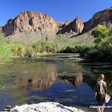
Yes, it's a zip code. I enabled the zip code layer (I forget what it's called right now) in Google Earth, and that's what shows up near an area of the Goldfield Mountains that I've been trying to get to for at least two years now. I had always approached it from the west, but that meant hiking a mile or two over rough terrain before I could start hiking where I wanted to be, and I'm just not robust enough to do that. I finally decided that the only way to get there was to wade or use a raft or small canoe to get across the Salt River. Dave told me that usually in December the Salt is pretty low and he has waded across it then. So I was planning to check it out this December. I drove by there on Saturday, though, and the river looked almost dry. Woohoo!


I want to get up there. You can't really tell how low the river is in this picture.


Actually, there's no water where this horse with no name is standing.


I held my camera up and this kid jumped in front of me. I took the picture because more kids were on the way. Maybe they would have made the picture more interesting, but you know me.

So I studied Google Earth carefully and picked the spots on both banks where I would cross. I packed sandals for wading and snacks and lots of water. I brought my hiking stick so I wouldn't be stumbling around in the river trying to keep my balance on the slick, round rocks. I had a plan. I was prepared.


This is the river entry point I had picked on Google Earth. As I suspected, I had to go through a tunnel through mesquites and reeds to get here. I can also see my exit point on the far bank.


My exit point, right where it should be. You can't get in and out of the river just anywhere because of the reeds.

I sat in the sand and put my sandals on and waded in. The cold water felt great. Of course, the distance to the other side was much greater than it looked, especially since I was walking on smooth rocks covered in slippery water grass.


The rocks are dry, but it's wet under them and it stinks.


A really stinky part. This would make a great picture with water in the river.


On the far bank! I'm not across the entire obstacle presented by the river, though.

Getting across the water is the biggest hurdle, but it is by no means the only one. I knew there would be lots of paths through the brush to the river on the right bank because lots of people fish there. I knew from past experience that the left bank wouldn't be as easy.


Thick trees on the left bank.

It was easier to get through the trees on the left bank than I thought it would be. Lots of paths criss-crossed through there. I had to walk in a crouch, though. There were a lot of fresh horse droppings, so maybe they (the horses) made the paths. Soon I was at the final river obstacle; a vertical bank 15 feet high. I knew there would be spots where I could walk up it. I just had to find one I could get to through the trees. It didn't take too long.


Finally, completely across the river. Find the truck!

On Google Earth, you can see a faint trail going from near the river, up into the canyon I was headed for. I was on it after I got across the river, but I missed a turn after I went between a couple of hills and lost the trail for a little while. I knew I would come across it again, though.


I felt like I was halfway to my destination. Boy, was I wrong.
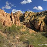

There's my canyon.

After a little while I found myself on a trail of sorts. It seemed too faint to be something that would show up on Google Earth. Maybe the Google Earth picture was taken after a wet spring. I was starting to wonder if I was following some horse trail (there was plenty of evidence that horses use the trail) when I came across a couple of cairns. Horses don't build cairns. I was on the trail.


A couple of cairns marking the trail. This part of the trail is not very well defined.

The trail was easy to follow most of the way. There were a few spots where it was too faint to be seen. Those were also the spots where there were no cairns. In those places I just went the direction that seemed right and it worked. I wanted to follow the trail because I knew that if I didn't, I would probably run into some dead ends.


The trail got very steep in the canyon. Fortunately, there was some shade.


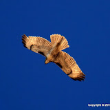
A red tailed hawk screeched at me now and then.


This looks like an easy trail here.


This is what a lot of the trail was like, though.


There were great echoes in the canyon.

Progress in the canyon was slow. It was steep, so I kept stopping to rest and cool down. Stopping was easy. It was nice to stand there and enjoy the beautiful new scenery. Since there was a trail of sorts, I didn't have to push through much brush or dodge many cacti. That helped a lot.


Near the top of the canyon.

As I approached the top of the canyon, I realized I was far behind my planned schedule. It had taken me about 40 minutes just to cross the river. Then it was another 2 hours to the top of the canyon. I had planned on 2 hours to get up there from the truck. I thought it would be easy to get from the top of the canyon to the cliffs overlooking the Salt River. That would involve more climbing, though, and it was quite a distance, and I was getting tired, and I knew that if I started down now it would be dark before I got back to the truck. It's not wise to be on unfamiliar trails after sunset. I wandered around a little up there, looking at all the places I wanted to go from there, and wondering how I could do it. The top of that canyon would be a cool place to pitch a tent. A 2 or 3 day hike would mean carrying a 35 pound backpack up the canyon, though. There is no water up there.


Going out there is more than I can do on this day.


A 360 degree panorama at the top of the canyon.

I got back to the river shortly after sunset. It's a little spooky going through those tunnels in the vegetation in the dark. It was a little spooking walking across that stinky river, too, but the cold water felt wonderful on my aching feet. I was really glad I had my hiking stick with me then. As tired as I was, and in the dark, I would have sat in the water several times without it. Click below to see all of the pictures.

BC_2010_11_07

Thursday, November 04, 2010

Sunset from Bulldog Canyon

I hurried out to Bulldog Canyon after work and got there in time to climb a small hill and watch the sunset. It looked like it might be a little too cloudy to the west for a good sunset, but it looked great.


The sun was close to setting by the time I parked.


Still a little light when I got to the top of the hill.


I just wandered around up there taking pictures of this and that.


Got lots of cactus silhouettes.

As the light faded, the coyotes started to howl. It sounded like there was one just a couple of hundred yards north of me. That's the closest I've been to a howling coyote in Arizona. As I crossed a wash next to the hill (a curvy wash with lots of paloverdes in it) on my way back to the truck, I heard some noises like horse hooves on rocks. Couldn't see anything, though. As I crossed another wash just beyond the first one, I heard something that sounded a little like a rooster trying to get started crowing in the morning, except it sounded really creepy. Made my skin crawl. It made me think of monsters. I thought about the kinds of monsters I was likely to encounter out there and that helped me relax because I'm pretty sure all the monsters were in town at that time. Then I thought about big cats and told myself that I didn't need to worry about that because they don't make any noise when they are on the hunt. They sneak up behind their prey and then leap silently and hit the neck so hard with their fangs they break it before the prey knows they're there. Silently. I stopped and stood very still and listened very carefully. I. didn't. hear. ANYTHING!

If a big cat is considering having you for dinner, there are two things you do not want to do. First, don't run. That would be like dragging a string past a house cat. They can't resist; they will pounce. Second, don't turn your back on it. If they think you aren't watching and they are hungry, they will pounce.

There's a third thing to consider; staring at a cat will be considered to be confrontational. You could make it mad and then it would pounce to show you who's in charge. Or you might convince it to leave you alone. If you ever encounter a big cat, you'll have to figure all that out on your own.

Anyway, I walked slowly and methodically back to the truck, stopping frequently to look all around. Never saw a cat. Darn it. Click below to see all of the pictures.

BC_2010_11_04