Monday, September 26, 2011

Another attempt at a Fish Creek Hill overlook

This time I went slightly north of where I did last time, and I went along the bottom of one of the many "canyons". It was much cooler that it had been the last time I was out there; just 95 or so. There was also a very nice breeze blowing. Pretty close to perfect weather. I like it warm.


I followed the canyon just to the right of center, though not at the very bottom; too many plants there.

There were lots of side canyons and I could see that a person could quickly get confused about which direction they had come from when trying to find their way back. I got out there kind of late and didn't have a lot of sunshine left and I was getting hungry, so when a cloud got in front of the sun and made it seem much later than it was, I turned back.


I saw what looked like a rock climber stuck on a cliff face in the distance. Turns out it was a light-colored rock.


I was out there late enough for good lighting.

I went out there mostly to enjoy some peace and quiet and solitude, and I accomplished that. I wasn't at all disappointed about not getting to a point where I would see the road going down Fish Creek Hill. I'm going to change my approach the next time out there. In the direction I've gone the last two times, I would have to be right on the cliff edge to be able to see the road below, and we all know I can't stand to do that. Next time, I'm going to follow a ridge south of where I've been going that should give me a good view of the hill. Click below to see all of the pictures.

2011_09_25

Thursday, September 22, 2011

Wednesday afternoon stroll

It seemed so cool again on Wednesday that I went for a short hike. It was below 100 when I parked the truck. I went out by Canyon Lake again because there's lots of places I haven't seen out there that are easy to get to.


The landscape is very rocky around Canyon Lake. There are also a lot of power lines.

It turns out that I was in Willow Creek again, further upstream than I've been before. I went down there because there is so much solid rock. I thought it might make some interesting pictures. The sun set too soon, though. Actually, it was blocked by mountains.


This cholla skeleton would have looked better with the sun shining on it.

I've been planning to get another super panorama of the Superstition Mountains, this time from Silly Mountain, for a while. I thought Wednesday might be the perfect day for it. The air seemed very clear, but on the way there I saw that there were a few clouds on the horizon that I didn't want in the picture. Wound up at Willow Creek instead.


One of those clouds.

As I was headed back to the truck, I saw a cloud that had an odd shape for a cloud. I had seen smoke on the way out there and so I thought that maybe that's what it was.


An odd-looking cloud that turned out to not be a cloud. Well, not a water cloud.

Before I went back to the truck, I climbed a hill near it and was surprised to see that it looked very hazy in all directions. I couldn't smell smoke, though. I decided that it must be dust. It did arrive with a gust of wind, but not a very strong gust. It must have been very fine dust. I tried getting pictures that show it, but it was getting dark.


Dust in the air.

It looked like the dust went all the way out to Four Peaks. It covered the Superstition and Goldfield Mountains. Good thing I hadn't been trying to get that super panorama. Click below to see all of the pictures.

2011_09_21

Sunday, September 18, 2011

Willow Creek to the Salt River

I was very curious to see what the rest of Willow Creek looks like. I went back to it on Saturday afternoon. A long time ago, somebody must have dumped a lot of 50 gallon drums near where I parked this time. They were scattered all along Willow Creek and the wash I followed to Willow Creek. Made me wonder what kind of toxic wastes might have been dumped into the water supply.


Old tires, 50 gallon drums, and shot up cans, bottles, and hub caps define this hike. One of the reasons I don't like hiking so close to busy roads.

I had trouble with my DeLorme PN-40 on this hike. Since I was in a narrow canyon, it couldn't acquire enough satellites to navigate. That shouldn't be a big deal, BUT the PN-40 asks if you want it to continue searching for satellites or give up. Since the receiver is in a pocket of my backpack, I don't know it's waiting for an answer. Still, that shouldn't be a complete disaster. I mean, I should have the GPS track up until the point that it was unable to navigate any more, right? Wrong! The two times that my PN-40 has gotten into this situation, it deleted all the track data it had collected up to that point. I might as well have never tuned it on. Seems like a serious software flaw. I'll have to check online sometime and see if there's a fix. This time, not only did it delete all track data (which is stored in non-volatile memory, so it wasn't deleted because of what I had to do next), but it froze up like a Windows PC. None of the buttons did anything. I had to pull the batteries out before I could do anything with it. This behavior is really aggravating. Good thing I don't rely on it for anything other than geotagging pictures. For some of Saturdays pictures, I knew exactly where I was when I took them. For a lot that I took in Willow Creek, though, I had to guess.


This PN-40 and the track it had saved until this happened are toast.

Anyway, back to the hike. I stumbled across some javelinas. There were at least 3 and they all ran different directions. I tried to get pictures but they didn't turn out very good.


Here's a javelina leaping through the air.

The closer I got to the Salt River, the steeper Willow Creek became and the larger the boulders in Willow Creek. I took me almost 15 minutes to cover the last 200 feet of the hike. It would have taken some rock climbing equipment to go any further than I did.


A view of the river, which is good since I couldn't go any further.

I didn't stay there long. The sun was getting low and so I had to get close to the truck before it got dark. Also, I wanted to be able to see the javelinas if I came across them again. Not because I like seeing javelinas, but because I like to keep an eye on animals that can tear me up if they feel so inclined. Click below to see all of the pictures.

2011_09_17

Friday, September 16, 2011

Back to the dry waterfall

I kept wondering what the place where that dry waterfall I saw last week would look like from the creek at the bottom. Wednesday was another cool day (I think the high was 99), so I went back. The trail I had seen in Google Earth was well-worn and easy to find and not too steep. I got to the bottom and a little ways up the other side to get pictures. It wasn't real impressive, but I'm sure it looks better with water.


Location of the waterfall. Imagine some water.

On the way down, I noticed the the view downstream was nice. I still had some sunlight so I headed that way. As I left the area where I had come down to the creek bed, I stopped and looked around at the area for a while. I didn't want to miss my exit on the way back.


Downstream. Could be interesting.

Every time I've hiked near Canyon Lake before, I've headed to the tops of hills or mountains because the view is usually spectacular. This hike was completely different but still very interesting. It was someplace that I had never been, and I couldn't even see any place that I had ever been. It was a little eerie. The best thing about it was how quiet it was. The drawback to hiking near the lake is all the traffic noise. Down in the canyon, I couldn't hear it at all. There were no bug noises, and few bird calls. Just my breathing and the crunching of my footsteps. Oh, and my camera shutter now and then.


A canyon wren posed for pictures. Well, I was in a canyon.

As I walked along, I kept thinking that I might see the lake or the river that drains it around the next bend, or maybe the bend after that. As sunset approached, I got my GPS receiver out to see where I was. It was another half mile to the river as the crow flies, and almost a mile the way I stagger over boulders and around bushes and trees. The moon wouldn't be up for quite a while after sunset, so it was time to head back. I don't carry a flashlight bright enough to find the landmarks I had memorized. I got back with light to spare.

I want to go the rest of the way to the river. There's another place I can park that will easily get me to where I stopped this time. Some time soon...

Click below to see all of the pictures.

2011_09_14

Monday, September 12, 2011

A (dry) waterfall, and a haboob

Saturday was wonderfully cool (only about 100), but there were lots of showers around so I didn't go hiking. I did drive around in some heave rainstorms, though. It was still pretty cool on Sunday (I think the high was 99), and the showers were smaller and further between, so I headed out to a place near Canyon Lake that I have been meaning to check out. There's a road next to an old corral that I've seen a couple of vehicles going down. When I got there, there were signs saying that the road was closed to vehicles. No problem, I was out there to hike anyway.


Parking spot with fluffy clouds.


That vertical sign in the middle says "No vehicles".

My only plan was to wander around a little and see what I could find. When I was beyond the end of the "road", I noticed an interesting cliff to west and decided to get a closer look at it after I got pictures of the nice view to the east.


The view to the east.

It turns out that the interesting cliff probably has a very nice waterfall pouring over it when it rains hard enough. I couldn't get a very good picture of it, though. I would have had to get close to the edge to do that, and it was at least a 20 foot drop. I don't like being on cliff edges when I'm taking pictures. I really need to get a stereo picture from the bottom. I was looking at Google Earth tonight and it looks like there might be a path down to the bottom just east of the waterfall. I'll have to make plans to hike down there during a good soaking winter rain.


Speaking of rain, there was some on the way.

It looked like it might rain while I was out there, but it would probably be a light shower, with lots of lightning and probably dust. I didn't want to be out in it. I headed for the truck and started driving back. As I drove along Apache Trail, I saw dust obscuring the Santan Mountains to the south. When I finally got to a place that I could see across the valley to the west, I saw a wall of dust headed north. It was a classic haboob. We've had several of those this summer, but I was never in the right place at the right time to get any pictures. I was on the shady side of this one, but it was better than nothing.


Haboob heading north.

I was about 5 miles from home when I got into the dust myself. It wasn't very thick on my side of town. Click below to see all of the pictures.

2011_09_11

Wednesday, September 07, 2011

A brief respite

As I walked to my car after work yesterday, I marveled at the fact that it didn't feel like the skin on my face was being set on fire. It was only about 105 when I got home. I grabbed my backpack and camera and headed for Bulldog Canyon. It was only about 101 when I got out of the truck. Since it was so cool, I headed uphill.


Every time I've walked by this, I've thought about climbing it. Finally did it.

I headed up a slope that I've looked at many times, wondering if it would be possible to walk up it. Sometimes it looked easy and sometimes it looked impossible. I guess it's a little of both.


The view from where I stopped climbing.

It was easy because I was always able to find paths that were not extremely steep. I realized that it could be difficult getting back down if I wasn't able to retrace all those little twists and turns. I did in fact make a major wrong turn on the way down and had to double back a little ways when I got to a dead end (in the form of a 20 foot drop).


That's Four Peaks back there.

I stopped before I got to the top for several reasons. First, I am out of shape. Second, I was unfamiliar with that area. Third, it was getting close to sunset. Being in an unfamiliar area when you are tired and it's dark is one step away from disaster, so I didn't push things by going the last few feet to the top. Also, as anyone who has done any climbing at all knows, when it looks like you are close to the top, you aren't. I got back to the truck well before sunset. It was back to being toasty outside today. Glad I went for a hike while I could. Click below to see all of the pictures.

2011_09_06

Sunday, September 04, 2011

Rock Creek

I had decided that it was just too hot this summer to be taking Photo Point pictures, but by Friday evening I was anxious to go get some more pictures. I headed out toward Roosevelt Lake again. It was smokey when I left the valley, and it was smokey when I passed through Miami / Globe. There are a couple of forest fires that are putting out a lot of smoke. They are small compared to some we've had this summer, and with the monsoon humidity they aren't going wild, and they were started by lightning, so the forest service is letting them burn.


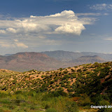
You can see smoke from one of the fires in this picture, if you know where to look and look closely.

I had coordinates for all the photo points already entered in my GPS receiver, and most of them were along a road, so I didn't waste much time wandering around in the heat. Still, whenever I walked over cottonwood leaves scattered on the ground, it sounded like it was raining from all the sweat dripping off my face. It was only about 100 and I wasn't doing much climbing, so the humidity must have been up. Also, I seem to sweat a lot more when I'm working on something. If I'm in the driveway changing a car battery, I'll be drenched. If I'm hiking I don't even sweat that much going uphill. Maybe it's because just hiking is so relaxing. Searching for photo points must be a little more taxing.

The first photo points were near a forest service cabin, which seems to be unoccupied at the moment. One of the photo points there was near wood piles and a thick layer of leaves on the ground and tall grass and other stuff. I don't normally worry about rattlesnakes while hiking because I have a good view of the ground. If I see them before I'm within striking distance, there's no problem. If there was one near that cabin, though, I could have stepped on it before I saw it.

A couple of recent photo points have been like that. They seem harmless and probably are harmless at least 95% of the time. After 8 years of hiking alone in the desert, I have developed rules for myself to avoid risky situations, and it's difficult to go against them. No hiker plans to get bitten, mauled, dehydrated, or fall off a cliff, but all it takes is two mistakes and you can be in big trouble. Going into a risky situation is a mistake that can be avoided if you recognize the risky situations. The second mistake will be a surprise (stepping on a snake, losing your footing, etc.), so you can't always prepare for it. Best to avoid the first mistake. If the first mistake can't be avoided, then you need to be very careful because you're one step away from disaster instead of two.

Speaking of losing your footing, I did that yesterday on the steep bank of a creek. I slid all the way to the bottom on my butt. Must have slid a foot and a half. That's why I avoid long steep slopes or steep slopes with a cliff at the bottom. I couldn't avoid the second mistake yesterday, but I didn't make the mistake of being on a dangerous slope, so it was no big deal. I didn't even get dirt in my pants this time (yes, I slip and fall down once or twice a year).

I didn't take a lot of non photo point pictures on this outing. That's one way I can tell that I've been out in the heat too long. If I look and something and think that I should take a picture of it but I don't because it's too much effort, it's time to get out of the sun. Anyway, click below to see the few pictures that there are.

2011_09_03