Sunday, February 24, 2013

Foiled again

Saturday was a beautiful day, so I decided that I should try to hike to the arches west of Service Road 80. I was a little concerned about being able to hike that far. In the past couple of months I've had the flu and two colds. It was too beautiful of a day to do anything but hike, though.


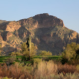
Maybe it was just too early in the day, or maybe I just don't know how to take a picture, but this is much prettier when you are there.


There were things to take pictures of in every direction, but you wouldn't be able to tell the foreground from the background without getting in just the right spot to take the picture.

My plan was to follow a creek bed all the way to a tall rock column, where I would start climbing. I had been to the creek bed where I was going to start out about 7 years ago, but I only had a vague recollection of what I had encountered over there.


There was a little water flowing through the creek.


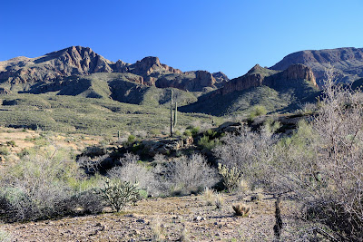
There are lots of hoodoos in this area.

What I remembered was that I came to a small canyon that I didn't want to cross because it was too hot for any exertion. If I had been there on a cooler day back then, maybe I would have remembered that I didn't cross the canyon because it wasn't possible to do so. I may not have known that I couldn't even get into it by starting further upstream, which is what I did on Saturday. Everything was fine until I came to a 15 foot drop. I tried taking pictures of it but that doesn't work so I tried a video.


That didn't work too well, either, because I was afraid to move my feet while concentrating on a camera while standing on slippery rocks at the top of a 15 foot precipice. Well, if you think you can do better, go for it. I'll stand by with a rope and my Spot to signal for help.

BTW, that reminds me, if you are injured and bleeding and push the 911 button on your Spot, you are going to bleed to death if you don't stop the bleeding yourself. In this area at least, the first response to a call for help is to send rescuers on foot. They will evaluate the situation and send for a helicopter if it's necessary. The point is, even though that button says "911", don't expect an ambulance to roll up 10 minutes after you push it. You may need to fend for yourself for a few hours. If you are in a remote area with no cell service, you need to be prepared to handle whatever comes up for at least a few hours.

Anyway, I decided to try going around on the right side of the small canyon because there was a side canyon on the left. This involved a small amount of uphill hiking, which is when I found out the back-to-back colds had taken more out of me than I realized. I felt like I was hiking at 7000 feet. I was glad I had encountered that obstacle so early in the hike.


Looking back at the waterfall. You know, the best way to show what this is really like would be to fly an RC helicopter with a camera over it.


The side canyon on the left side, which looks like it has its own side canyons.


I want to be down there. There is no way to get there. Well, there is, but it involves either a long hike or long ropes.

The small canyon has steep sides for as far as I felt like hiking that day. I'll have to go back and try a different route another day. Click below for all the pictures.

2013_02_23

Tuesday, February 19, 2013

Treasure hunt

While trying to decide where to go for a short hike, I remembered that I have a metal detector. I haven't used it for over 10 years. Had to put fresh batteries in it. I decided to see if there was any treasure left in the Salt River.


I don't remember if I've ever seen this so green.

I headed for an out-of-the-way spot, thinking that other treasure hunters might not have been there. I found out that there are a lot of rocks that set off my metal detector. I was afraid that would be the case. I also found a couple of pieces of beer cans. Then I found lots of holes in the riverbed. Somebody had been there a day or two before me. I had decided it was a waste of time and was about to leave when I spotted some platinum.


James, I found your platinum debit card.


Well, the scenery was nice.

Click below to see all of the pictures.

2013_02_19

Sunday, February 17, 2013

A maze of canyons

For various reasons, I wound up going for a hike near Mesquite Flat. It's pays to be flexible. It's a good idea to have several hiking destinations in mind. Anyway, I was planning to hike up a creek bed and see how far I could go.


It started out OK. Just a little water here and there.

I hadn't gone too far before I got to a spot where it was not possible to continue upstream without wading. I know that because I tried to go around on both sides. Some guys in the creek bed told me I would be able to climb down in one spot but it looked too risky from where I was.


A large puddle. Actually, it was flowing. Puddles don't flow, right?

I was about to take off my shoes and start wading when one of the guys pointed out that the next puddle looked deeper. I'm glad he mentioned that. I had gone as far as I was going to go in the creek bed.


People enjoying a beautiful day in the desert. In the dark shadow upstream of them is a deep puddle.

So I headed up to the top of the nearest ridge. This area is all narrow, steep-sided canyons with narrow ridges between them. I didn't know how far I would be able to go along the ridge. Some of them end abruptly. I thought I was at the end several times but was able to keep going when I got a closer look at the "end". I also thought about descending into a canyon and following a creek bed out of there. I didn't do that because I didn't feel energetic enough to retrace my steps if I came to a dead end, though.


If you are down in the canyons, you can't see very far and it's hard to tell where you are. Well, you could use GPS, but where's the adventure in that?

Shortly after I started heading north along the ridge, I spotted another solitary hiker. This person was wearing camo and carrying a tripod. Looked like a serious nature photographer. In looking at the pictures later, I decided the photographer must be female, too. At least I've never seen a guy with hair that nice.


A solitary hiker, possibly looking for critters to photograph.


There are some scenic mountains to the south.

As so often happens when I go wandering semi-aimlessly, I came across some cairns. I accidentally followed them for a while. They were going the same way I was. I wonder why people build cairns along a ridge that you couldn't descend from if you wanted to or along the bottom of canyons that you couldn't get out of even if a pack of javelinas was inviting you to dinner (as an entree). You can't wander off the trail, so why say "Here's the trail"?


A moot cairn.

I found a small stone "arch". I couldn't get a good picture of it so I made a video.


Video of a small stone arch.


More of the maze.


More moot cairns.

Click below to see all of the pictures.

2013_02_16

Thursday, February 14, 2013

New discoveries, just around the corner

This past weekend, I had planned to hike up to the arches I had seen the previous weekend. When I left the house on Saturday, it was overcast and gloomy and I could see rain falling here and there and it was cold (well, about 50) and breezy. I wouldn't like any pictures I took in such weather and I would have to keep moving to keep warm. I talked myself out of hiking before I had driven 4 miles. I kept driving east, wondering where I would wind up. The first place I stopped was just west of Superior. I saw a dirt road heading south and decided it needed exploring. After driving about a quarter mile, though, it crossed Queen Creek. There was actually water in Queen Creek and the bed looked very muddy and slippery. I'm sure Skid would have enjoyed some excitement that afternoon but I didn't want to have to call him out there to pull me out of the mud. I headed back towards 60 and turned east at an intriguing sign.


Why would a sign point to wagon tracks? Is it really wagon tracks or a town called Wagon Tracks?

As I drove along, I came to some tire tracks through some mud. Surely that isn't it. I kept going and, sure enough, there were wagon tracks. In stone. Deep wagon tracks.


The tracks have cut almost 2 feet into the stone in places.


Notice the holes down the middle.

I did some Googling last week and found out that the tracks were made by wagon loads of silver ore coming from mines to the north to a mill at Queen Creek, in what used to be the town of Pinal. The holes down the middle were made by the mules pulling the wagons. Allegedly they always walked in the same footprints.

Well, that was interesting. Before I knew it, I was back on the road and headed toward White Canyon Wilderness. The road goes right by the entrance to the wilderness but I had never driven on that road before because I thought it was too steep for me to be able to drive out. I knew that wouldn't be a problem now, though. So I drove a couple of miles further along that road and discovered that there is lots of fantastic scenery back there. Too bad it was so gloomy.

The wind wasn't blowing as much the next day, though the temperature was about the same. The sun was out, and there were small, fluffy clouds. I loaded up the Ranger and Sweetums, Emily, and I headed back out there.


A large parking / staging area has been built just off of Hwy 177. There were only two other vehicles there when we arrived. Nice view from the staging area.


One of my favorite views. We'll be circling around that peak on the left.


At the high point along the road, there are beautiful views all around.


Looking another direction from the high point. The trail you see halfway up that slope on the left is the Grand Enchantment Trial.

Emily got out to run around when we stopped at the high point in the road. She did not want to stop running around. Can't blame her. She convinced us that she's probably still too young for such adventures. She fell asleep a few minutes after we got moving again.

I saw at least 3 places out there that I'm going to have to try to hike to. A couple of them are rugged (scenic) looking canyons. The third is a hollowed out spot on a cliff face. There's a trail going up to it, so maybe there's something interesting up there. Even if there isn't, it will be a nice hike.


Notice the trail going across to that "cave" in the cliff face.

Wandering around aimlessly can result in some interesting finds sometimes. Click below to see all of the pictures.

2013_02_09

2013_02_10

Sunday, February 03, 2013

Something new on an old trail

Saturday had high, thin clouds. I don't like those so I didn't go hiking. Sunday brought gloomy, overcast weather with a chance of rain. I should have gone hiking on Saturday. I had a couple of places in mind that I wanted to explore but I wanted to do that when the sun was shining so I could get some good pictures. I left the house not sure where I would end up. Well, I do that a lot.

I wound up near one of the places I wanted to explore. I had seen a picture of a couple of arches on Google Earth and I wanted to get a look at them myself. I decided I would check out possible routes to the arches. I'm still recovering from having the flu a couple of weeks ago so I didn't want to go on a long hike.


I had been out here with Lauren a few years ago and had been meaning to get a geotagged picture for a long time. I don't remember the cross being there last time.


I also wanted to check the location of this. I have a picture of these "kissing rocks" on Panoramio and some character that calls himself James Bond said he had looked all over the place out there and couldn't find this. He must not be the "real" James Bond, then.

I started going along the trail that eventually gets to an overlook of the Salt River. I wasn't planning to go very far along it. Every time I stopped, though, I decided to continue to the next ridge or the next turn. I got to the part where it starts climbing steeply when I decided I had really gone far enough. A cool breeze had started blowing and I was worried it would start raining. I stood there enjoying the view for a couple of minutes before heading back and suddenly noticed something I hadn't seen all the other times I'd been there. There was a large stone bridge that must be one of the arches I had seen a picture of on Google Earth.


There's aa arch in the center of this picture. Earlier I was looking at paths in the green below that stone "tooth" and had decided they had been made by animals. Now I wonder if they had been made by people visiting the arch.


Zoomed in on the arch.


I took this so the geotagged picture would show where I was when it started raining.

It did rain a little while later. It didn't rain hard enough to get me wet, though. Click below for all of the pictures.

2013_02_03