There are some interesting rocks along the way.

This slowed me down, somewhat.
If I had gone down the long steep slope to get back to the creek bed, I would then have had to climb a few hundred feet to get to the arch. That was more than I could do after two weeks on the couch. Instead, I took my time wandering back to the truck and took lots of pictures of rocks.

I made some stereo pictures, too. It isn't possible to get into a good position to get pictures of some of the rocks, so they just blend into the background. With stereo pictures, it's possible to see what's what. These are viewed by crossing your eyes so the left eye looks at the right half and the right eye looks at the left half.


I have asked several people what they think of the stereo pictures and they say either "I only have one eye" or "My mother told me that if I crossed my eyes they would get stuck like that." I don't think anybody has told me that they can see the 3D effect yet. Well, I guess I'll keep making them for my own amusement. Click below to open a new window with pictures from that hike.
 |
| 2014_01_12 |
I was in better shape by the next time I went out there. I studied Google Earth and planned my route. I packed plenty of water and charged the camera battery. I was determined to get to the arch this time, unless I didn't. Well, I'm not going to drop off a cliff I can't climb back up. It wouldn't be any fun getting to the arch if I couldn't tell anybody about it.
I went out there on the Saturday before MLK day. I had no idea so many festivities were planned for that day along Apache Trail. When I got past most of the traffic, I was still stuck behind people going 20mph for who-knows-why. Fortunately, I had left the house early and had plenty of sunshine left by the time I got out there.

My destination is near the big rock poking up just to the right of center.
As I had seen on GE, I had to clamber over several rock piles and find my way through a few sudden elevation changes to get there. There was no hint of a trail.

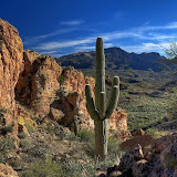
I got a nice picture of an agave along the way.

Lighting was not good for pictures of Black Cross Butte.
It seemed to take a while, but I got to the large rock that I knew was very close to the arch without too much difficulty. I was trying to figure out how I was going to get around it when I suddenly realized that I was right next to the arch. I didn't need to get around the rock.

I took this while I was trying to figure out how to keep going, but the top of the arch is in the lower left corner of this picture.

There are actually two arches, side by side.

Here's a picture that includes my shadow for scale.
I tried to figure out how to get to the base of the arch to get pictures from there, but it looked like I would have to hike another mile to do that and I felt like the pictures I had were good enough.

A stereo picture of the arch. Now I know everybody out there would never do anything their mother told them not to do, so I guess I'm the only deviant that will enjoy the 3D effect.

As is often the case, the route back was not as obvious as the route out. I did have to double back at one spot on the way back.

I got a nice picture of a saguaro on the way back.
One reason I didn't want to try to hike down to the bottom of the arch was because I had gone pretty far already over unfamiliar terrain that required specific routes to get across. I wanted to head back before I forgot the way or before I tried to remember too much. I could retrace my route using the PN40, but it could be dangerous to rely on high tech devices so I don't want to get into that habit. Also, I would be much more tired after hiking down there (if I was successful), which can lead to bad decisions as the sun is setting. People sometimes express concern about me being out in the desert by myself, but I'm very careful about what I do. I try not to make any decision without actually thinking about it because I know it's easy to casually wander into a disaster. Click below to open a new window with the pictures from this hike.
 |
| 2014_01_18 |
Now you may be wondering why I'm not done, since I had made it to the arch. Well, on my way to the arch I saw some interesting landscapes further to the south. I wanted to see what that area looked like up close. I thought I might also be able to get some pictures of the maze of canyons even further to the south from up above. Again, I studied GE and again, I wandered off into the great unknown. I love doing that, as long as it's not so unknown that I have to carry my own environment with me.

I didn't see anything spectacular on this hike. Just the usual beautiful landscape. It turns out that my view of the maze of canyons was blocked by a ridge. I took lots of pictures, but none stand out. I like to look at them because I can see lots of other places I've been in them, but they might look boring to anybody else. Like 'em or not, click below to see all of the pictures.
 |
| 2014_01_20 |