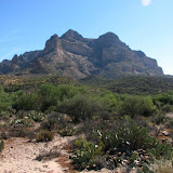
Location: Picketpost Mountain, near Superior, Az.
Time and temperature: Start - 1123, 82
End - 1718, 78
Elevation change: 1757 feet
The numbers:
51 Pictures taken
7 Other hikers seen
6 Times I lost the trail
4 Times I seriously thought about turning back
Ramblings: Wow, what a hike. What a killer of a hike. I did have fun, though.
I started out by starting too late. I should have shopped for supplies last night. It was a little warm by the time I got on the trail, but it wasn't hot enough to be a problem. The problem was limited daylight. A sign said the parking area closed at sunset. There was a caretaker there that would probably have my truck towed if I was late getting back.
The trail was not bad for the first mile or so, except for how far away the mountain looked. I kept thinking that I wouldn't want to walk that far on level ground, much less on ground that looked like it went straight up. Then I met Conrad. He was sitting in the shade of a large rock on the side of the trail. He was waiting for his son and grandson to get back from the top. He seemed embarrassed that he had to sit there and wait. He talked about training with a heavy pack and coming back. He turns 75 next month. I think he's doing pretty darn good.
Just past Conrad's rock, the trail got steep. Then it got steeper. The trail was also difficult to follow in places. It's marked with cairns and paint spots, but a lot of times I would be walking (or climbing) on what seemed to be the trail, and it would just end. I would look around for a few minutes trying to find a trail marker and sometimes explore a little ways in various directions before I found it again. One of those times was when the trail was going up the middle of the canyon and up ahead I could see that it was nothing but polished rock going almost straight up. I might be able to climb it, but it looked too risky. That was one of the times I thought about going back. I looked around and saw that the trail went to the left, though, so I continued my quest.
There were also times when I knew I was on the trail because I could see markers up ahead, but the trail still looked treacherous. Several times I had to stand there and pick a route, take a few steps, then stop and make sure the route still looked like it would work from this new vantage point. Sometimes I would stand there planning the next 2 or 3 steps and going over the plan again and again before moving. The trail was sort of scary on the way up.
At about 2 in the afternoon, I stopped to have a snack. I got to thinking about how much sunlight was left and thinking that maybe I should turn back now. I got out the GPS to see how far I was from the summit. It was 0.3 miles distant and 400 feet higher. I thought about coming back next weekend and realized that the memory of how difficult the climb had been would be too fresh. I had to go on; it's now or never.
The rest of the way to the summit wasn't too bad. There's a mailbox full of notepads for people to write stuff at the summit. A note written on aluminum inside the door of the mailbox explains its history (see the pictures). The note reminds me of Dad's humor.
I figured I should leave the summit at 2:30 to get back to the truck before sunset. I got to the summit at 2:40, though. I took a few pictures and left at 2:51. That reminded me of going on trips with Dad. Drive for hours and hours, stop and look around a few minutes, then drive back.
The hike back down was really scary because I could see what I had my back to before. I would be walking along a steep downward slope and it would look like it ended at a sheer cliff ahead. Sometimes that was because I had lost the trail. Sometimes it was because that's what the trail was like. Well, I didn't have to go off the cliff, but I would turn up ahead or it wasn't quite as bad a cliff as it looked like. I was going slowly and carefully. Fortunately, my thighs didn't start cramping until I was back down to Conrad's rock. I felt relieved because the trail wasn't nearly as steep from there on down to the parking lot. It was a lot steeper than I remembered, though. It was a shame I had to hurry. I think I could spend several days on that trail taking pictures of all the neat stuff.
I Geotagged all of the pictures, but the ones in the canyon are just guesses. Google Earth isn't detailed enough there for me to figure out exactly where I was.
 |
| Picketpost |


No comments:
Post a Comment