Showing posts with label Salt River. Show all posts

Monday, November 02, 2015

Hike to a Lime Kiln

At least that's what I think it is. I could be wrong. I don't think there's a lot of limestone out here, but there could be some, I suppose. Anyway, somebody told me about this and about where it is and I think they told me what it is but I can't find that conversation. I wish I could so I could let him know I finally made it out there and so he could confirm if it is a lime kiln.

So somebody told me about this thing and I searched for it on Google Earth and found a likely candidate and stuck a push pin in it and thought for a couple of years about how long a hike it would be to get out there. Then last Friday I decided I could reduce the hike by at least a couple of miles by wading across the Salt River instead of using the bridge. I did that once before on another hike. I wore sandals made for use in water that time. It was a little chancy going up the far bank in sandals, though, what with all the cacti and rattlers around. On Saturday morning I decide to go down to the river and see if it would be as easy to cross as I suspected.


There were only 2 horses in the area when I got to the river. The flow of water from Stewart Mountain dam is cut in October because the Salt River tubing season is over. All those rocks in the foreground would normally be under water but are exposed because the flow was dropped last week.


You can kind of tell where the water was in this photo.

I went to the place that was my first choice from crossing the river and decided that it was too wide. I didn't pay much attention to how deep it was but probably should have. I made my way over to my second choice but it took me a long time to get there because I kept stopping to take pictures of birds.


This is how birds fish.
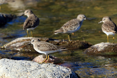

These birds are cuter.

I don't normally take pictures of birds but I got a new lens a couple of months ago that enables me to zoom in enough to get decent pictures. That lens is not suitable for landscape photography, though, and that's the kind of photos I most like to take. So am I changing lenses while I'm out hiking? What, and get all that desert dust in my camera?!? No. I carry two cameras. I got a new camera in January and BTW it is the heaviest camera I have ever owned. I kept my old camera and put the new lens on it. The new lens, BTW, is the heaviest lens I have ever owned. So now I'm carrying 2 instruments for taking pictures and each one is heavy. Have you ever put two camera straps around your neck? Having two heavy cameras strapped to your neck can make hiking difficult for lots of reasons besides impeding breathing, though that is certainly one of the top reasons. Fortunately, I stumbled across a solution to carrying the cameras a few weeks ago. They are something called "capture clips" made by Peak Design. I put them on my backpack straps and hang the cameras there. It's a little awkward having two large heavy things on my chest but it beats being strangled.


Me with cameras attached, and a bonus Halloween decoration.

OK, so I'm looking at my second possible location for crossing the river and I think it looks a little deeper than I would like if I was to try crossing it with my hiking boots on. I've splashed through this river a few times with these boots and they do seem to be water proof, as advertised, so I decide to see if the water is too deep. I think it was about half an inch too deep. One of the most distressing feelings I know is that of water coming over the top of your shoe and down into your shoe. It's right down there with hitting your brakes and then realizing that you are on ice. It was only a few steps to get across, though, and it didn't get any deeper, so I kept going. When I got out of the water and up the other bank, it felt like the water had only seeped down to my heels and had not formed puddles in my boots. Puddles in boots is one of the few things that feels worse that water coming over the tops of your boots. I decided that since I was across, I might as well keep going.


The ground is unusually bare in this area. I think that may have something to do with the nature of the soil. There are no rocks in this soil. Every time I have come across soil without rocks in this desert, it has very few plants in it.


I got the feeling that few people visit this area these days. There were many dead trees that had not been chopped up for firewood. Also, there were few beer cans or shot gun shells.

I wandered slowly in the direction I thought I should go to get to the suspected kiln. I had a 4G signal out there and figured I could check Google Earth if I couldn't find it, but it would be more fun to wander around and see what I could see.


I felt like I should be getting close to the kiln so I decided to climb this small hill and see if I could spot it.


Almost at the hill ...


... when I look to my left and see this.


This matches descriptions of lime kilns that I've read.


At the same time that I got to the kiln, the Red Baron flew in and started doing aerial stunts. I used to see this plane frequently while hiking but haven't seem it much the past few years.

I hung out there for a while taking pictures of the kiln and of the Red Baron. I decided to climb the hill even though I had already found my destination. It was during this climb that I concluded that hiking in wet socks is a lot less fun than hiking in dry socks. The hill was actually the end of a ridge. There were cairns on the ridge and a very faint trail. I couldn't resist. I followed the trail for almost half a mile before I decided the sun was getting low enough that I should turn back.


Looking along the ridge.


As is common in this area, one of Sheriff Joe's fancy helicopters flew by. It was doing some wild maneuvers to follow the path of the river. Maybe the pilot was trying to impress the female you can see in the front seat. I wonder how many of these helicopters Maricopa County could have purchased for the cost of all of Sheriff Joe's lost lawsuits.


I don't think the trail goes anywhere but the desert is pretty.


Large rocks.

As I strolled along the top of the ridge, I thought about how I used to run through the shallow water at the beach in Texas. When your foot comes down, it pushes the water out, and you lift your foot up for the next step before the water rushes in to cover it. I wondered if I could use that technique to cross the river. It might be tricky running over a bunch of slippery boulders that you can't really see very well, though. I decided to try it and was quickly reminded of how, when one foot splashes down, the other leg gets drenched. At least I didn't get as much water in my boots. I need to find a better way to cross the river. Stilts?


Map of the hike.

Click below to see all of the pictures. I took over 200 but narrowed it down some.

2015_10_31

Wednesday, May 01, 2013

To an overlook of the Salt River

The area in which I've been hiking lately is bounded to the north by the Salt River. I've been thinking that I should be able to have a nice view of the Salt River from some hills next to the river. That's where I went on Sunday.


One of my hiking companions.

I had to go kind to early in the day to be sure that I would have enough light for the hike back. I pretty much know the way now, but the weather has gotten warm enough that rattlers will be out hunting after sundown. Don't want to step on one. Anyway, the pictures look like they were taken in the middle of the day.


I thought I would be able to see the river by the time I got to this spot, but what I thought was water was a piece of road.

I couldn't see any of the river when I got to the spot from which I thought I should be able to see it. I thought that maybe the hills weren't as steep as I thought right there and that I would probably have to walk almost down to the river to see it. A peak to my left had shade on its east side, though, so I started wandering up there. It was about 95 and there aren't many saguaros along the way, so I had been out in the sun for a while and going uphill. I hadn't been climbing in the shade for very long when I came into view of the river.


The Salt River, looking upstream. Actually, it's more of an extension of Saguaro Lake from that dam up to the Canyon Lake dam.


Downstream view of the river.


From the top of the hill, I could see a little bit of Canyon Lake.


I could also see the Superstition Mountains in the distance.

The river didn't look nearly as interesting as I had hoped. I plan to check out some other views of the river out there if I don't decide it's too hot now. Click below to see all of the pictures.

2013_04_28

Tuesday, March 12, 2013

A side canyon

I can tell I'm still lacking some stamina just by driving around. I look at all the places I've hiked before and think, "That would take too much effort". So I decided to go someplace I haven't been before and where I had no idea how far I'd be able to go. That way, I wouldn't think it was too much effort until I got where ever I was going.


There was a fire a couple of years ago in the place where I stopped. This used to be a sotol.

I decided to try to hike down a side canyon of a side canyon of the Salt River. I've tried that before in that area (near Fish Creek Hill) and quickly came to a spot where I had to turn back. As I started out, I was surprised at how much water was flowing in the side canyon. We'd had a lot of rain two days before. The canyon only drains a small area so I hadn't expected it to still have water flowing. What I learned was that the water had soaked into the thin layer of soil on top of the rock and was slowly draining into the stream at the center of the canyon. Where there was bare rock, you could see the water draining across it.


I followed this as far as I could. Almost.


Water is draining into the stream where the rock looks black.

Since there was water flowing, I had another reason to go slow. I had to get pictures of all that water. I had my tripod but some of the small waterfalls were in shadow with sunlit rock nearby, so it was hard to get decent pictures.


Small waterfall around a large boulder.


This was nice to watch, but I couldn't get a picture of it that I like.


I made a short video of some of the water.

I hadn't gone far before I saw that I would have to stop soon. It looked like the view might be interesting from further downstream. Maybe a nice cliff that would stop me. I looked down there, though, and decided I just didn't have the energy to do it. That was a good decision. On the way back, I would stop and seriously study two alternative routes trying to decide if I wanted to try to hold some catclaw out of the way while hopping over some water or if it would be easier to climb up 5 feet over some rocks with no catclaw. I have the scratches resulting from frequently taking the easier but bloodier route.


If you look closely, you can tell that there is probably a cliff down there that I wouldn't be able to descend. Well, I could, but that would be the end of the hike.

Speaking of blood, that reminds me of a couple of things I saw along the way. On the way downstream I saw what looked like some coyote skin. Then on the way upstream I came across a skeleton. It was most of the torso of what must have been a deer. If the leg that was nearby belonged to it, it was a deer. Anyway, these decaying animal parts were all in or right next to the stream. That's one reason I carry all the water I'll be drinking with me.

Click below for all of the pictures. If you are squeamish, don't look at all of the pictures.

2013_03_10

Tuesday, February 19, 2013

Treasure hunt

While trying to decide where to go for a short hike, I remembered that I have a metal detector. I haven't used it for over 10 years. Had to put fresh batteries in it. I decided to see if there was any treasure left in the Salt River.


I don't remember if I've ever seen this so green.

I headed for an out-of-the-way spot, thinking that other treasure hunters might not have been there. I found out that there are a lot of rocks that set off my metal detector. I was afraid that would be the case. I also found a couple of pieces of beer cans. Then I found lots of holes in the riverbed. Somebody had been there a day or two before me. I had decided it was a waste of time and was about to leave when I spotted some platinum.


James, I found your platinum debit card.


Well, the scenery was nice.

Click below to see all of the pictures.

2013_02_19

Saturday, January 12, 2013

An oven, and horses

No, the horses don't have anything to do with the oven, except that they just happened to be in the same area.

I was surfing the web a few weeks ago and along one of the random rabbit trails I was following, I found a description of a hike near Saguaro Lake. It describe an oven built into the side of a cliff and had one so-so picture of it. About the only clue to its location was that the description said it may have been made by people driving sheep along a trail between summer and winter pastures. Well, the hike description described the loop they took, but I have trouble following verbal descriptions. I couldn't tell from the description whether the oven was on the Saguaro Lake side of the loop or the opposite side of the loop. I do know approximately where the sheep trail is, though.

It took two attempts to find the oven. The first attempt was on a weekday after work. I didn't have much sunlight. In fact, the sun had set several minutes before I started up the wash where the oven is located.


A trail follows the right bank of the Salt River to the wash. The trail is often used by fishermen.


The sun set while I was still following the trail along the river.

There's a parking lot at the trailhead, but it costs about $6 to park there. Being as cheap as I am, I parked over half a mile away at the Blue Point entrance to Bulldog Canyon.

On that first hike, I went up the wash until it got too dark to take pictures of anything but the sunset. No sense in finding the oven if I couldn't take pictures of it.


There are lots of footprints here. I think many of them are human, but there are also many horse hoof prints.

Well, obviously I didn't find the oven on that first hike. I didn't expect to. I mainly wanted to check out the trail along the river. I didn't even know it existed until I read that hike description.

I finally made it back out there a couple of weeks later. It was overcast and gloomy. Not good for landscape pictures, but I was looking for an oven.


See how gloomy it is? This would be a much better picture with sunshine.

Since I wasn't racing nightfall on the second hike, I walked a lot slower. I didn't have any idea how close to the wash the oven was, so I was looking for anything that might lead to something away from the wash. At one point I did spot some suspicious piles of rocks and climbed around for a while trying to find out why they were there.


There are at least two suspicious piles of rocks in this picture. One of them is hard to see. I didn't see the easy one until I looked at this picture, though.

I couldn't find anything besides cairns up there, and after a short while I couldn't find any more of them. I don't know if they lead to anything. I wonder if they might just be there to get people to a good spot to view an unusual saguaro. I have the feeling there might be something else up there, though. I need to go look again.


This saguaro is kinda funky looking.

The clouds started moving off to the east after a while. That's about the time I saw a pile of white rocks on the side of the wash. I was getting ready to take a picture of them when I spotted the oven behind them.


My first view of the oven.


A better view of the oven. You can see that it is built into the cliff.


The top of the oven.

While I was on the hill above the oven, I noticed a couple of wild horses across the wash. About the only place I've seen them before is along the Salt River. I've never seen them while hiking away from the river, but I see their hoof prints miles from the river. After I got a few landscape pictures I decided to see if I could get close enough to the horses to get some pictures. As I walked slowly and quietly up the other bank, I could see well-worn horse trails. It looks like they hang out in that area a lot. I didn't find the two I had seen earlier, but I did find six others. They didn't seem to mind my presence much. They even ambled past me like I was just another palo-verde. They also ignored my camera and didn't give me any striking poses.


A couple of the horses. They eyed me suspiciously and then walked by within 15 feet of me.


This horse seemed wary of me. It kept an eye on me the whole time.


I took lots of pictures of the horses. Most are of horses behind creosote bushes.

By the time I was done taking pictures of the horses, they sun was out. I re-took some of my other pictures now that the sun was out.


This saguaro looks much better with blue sky behind it.


I took more pictures of the river now that the sun was shining.


When I first saw these horses, I wondered if it was the ones I was taking pictures of earlier and they had run down to the river along a different route and were standing there like, "What took you so long, human?" Smart aleck horses ;-)


That's pretty.


Doesn't this look better than that gloomy picture?

As I approached the highway, I saw several people on the river bank with metal detectors. I talked to one guy and he said they find earrings, rings, watches, knives, etc. in the river bed (the water level is dropped in the winter). That doesn't surprise me, considering how drunk most of those people are.

The pictures are in two web albums.

2012_12_19

2013_01_06