Wednesday, December 26, 2018
The Wave Cave
A new trail has appeared in the Superstition Wilderness. It goes to the cave pictured above. I think you can figure out how it got its name.
I'm pretty sure there wasn't a trail up there when I first started hiking in that area about 12 or 14 years ago. The Wave Cave trail splits off of the Carney Springs trail. I was on the Wave Cave trail 2 or 3 years ago. I didn't follow it up to the cave back then because I didn't know it went up there and it wasn't an official trail then so there wasn't any signage.
The Wave Cave is in the canyon just to the right of the Three Sisters. I think the official trail is supposed to start at the Lost Goldmine trailhead on Peralta Road. I parked in a small lot before the Lost Goldmine trailhead that avoids a lot of pointless ups and downs and twists and turns before you get to the trail going up to the Wave Cave. Always capitalizing "Wave Cave" is making me feel a little like Trump (read his tweets). I have this strange urge to build a wall.
My truck is parked behind that black SUV in the small lot at the intersection of the 2 "roads". The hike was less than 4 miles and about 800 feet of climbing. It gets pretty steep towards the end. My GPS tracker says it's a 1000 foot climb but it also says that I was zipping around the mountain at 160mph when I was standing in the cave. Those things just don't work in caves.
Sunday, May 25, 2014
A better view of a hole in the rock
Part of the beginning of the trail is in fine sand, which is great for showing snake trails. I couldn't find the snake.
I had mostly forgotten about the hole in the rock until I spotted it from the trail. It's easy to miss. You have to look up at just the right time.
The hole in the rock isn't easy to see from the trail.
Somebody also dug a hole in the dirt on the side of the creek. Strange.

I would like to see this when water is flowing.
I walked until I got to a scenic spot and "stopped" there to take a few pictures. Actually, what I did was start up a hill to get a better angle on a shot. Then I went a little further to see what I could see, all the while looking across the creek bed at the taller hill on the other side until I couldn't stand it any longer and started up that other hill. The view was much better from the taller hill.

This is a bare-rock kind of place.
I was wandering around on the larger hill taking pictures of various things when I turned around once to find that I had a perfect view of the hole in the rock. Now, finally, years after I had intended to do so, I have a decent picture of that hole in the rock.
Click below for all of the pictures.
![]() |
| 2014_05_21 |
Friday, May 02, 2014
A return, of sorts
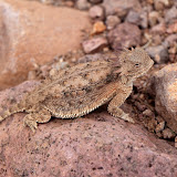
I haven't seen one of these for 2 or 3 years. I wouldn't have seen this one if he hadn't moved.
A little while later, I saw this one. Again, I wouldn't have seen him if he hadn't moved.
I saw 2 horned lizards on this hike. I don't think I had seen one for about 3 years before this year. I've seen 4 so far this year. I look around every time I pass a big red ant ant bed but if the horned lizards aren't moving, they are hard to see. Both of these were close to ant beds (they eat the ants).
Find the horned lizard in this picture. I have trouble seeing him and I know where he is. This is zoomed to how the scene would look if you were standing on the trail. You need to look at the picture full size, though.

There were some rain clouds in the distance. After 11 years in the desert, I knew I didn't have to worry about getting wet.

It is not unusual for a single prickly pear cactus to have 2 colors of flowers. I've seen two colors on one pad.
The rock I wanted to get close to looks sort of like a bent thumb sticking out of the ground. I had gotten pictures of it from a distance before but wanted to get closer. I was almost to the hoodoos before I thought I was close enough to the thumb to leave the trail and head for it. Unfortunately, I didn't see an easy way to get to it. I would have to go through steep-sided washes full of vegetation. I decided it wasn't worth the effort. Since I was almost at the hoodoos, I went on to them.

Nice-looking clouds over picturesque mountains.

Thumb rock. I still don't have a good picture of it.

I always seem to use that pointy rock as a gauge of how much I've climbed when I'm on this side of the mountains.
I didn't feel as tired when I got to the hoodoos as I remember being the first time I was out there. I sat in their shade and had a snack. I looked at all the other places I've explored since the last time I was out there and decided that I need to go to some of them again because they probably aren't beyond my reach now after all.

I like the view from up there.
Click below for all of the pictures.
![]() |
| 2014_04_19 |
Monday, April 01, 2013
From the Jacob's Crosscut trailhead to the Massacre Grounds trail
I was wondering if I would be able to find the trail when I bumped into this sign.
The trail is marked frequently with cairns but is well-worn now and would be easy to follow without the cairns. I was there kind of late in the day (on a weekday) so I only followed it as far as the beginning of the Massacre Grounds trail.
There's plenty of nice scenery along the way.
The trail is easy to follow, at least in the spring when it's lined on both sides with green.
In the middle of a stand of cholla.
I took lots of pictures of the Superstition Mountains.
I'll have to go back with more sunshine to see if I can make it to the end of the trail. The move adds a mile each way to the hike. It's an easy mile but my joints complain about long distances these days. Click below to see all of the pictures.
![]() |
| 2013_03_26 |
Monday, October 08, 2012
To the Miles trailhead
Anyway, I went out there to see what I could see. You don't have a good view of the mines from the road. I followed the road north until I got kind of close to the ranch house, then got bored with that direction and turned around. I stopped at a high point in the road to take some pictures.
A 360 panorama taken from a small hilltop.
The ranch house. I actually got a guy walking across the yard. You may not be able to see him in this version of the photo, though.
I then headed west on the road that goes out to the Miles trailhead. It's dirt, of course, but it was in very good condition. It was also a very nice drive through pine and juniper forest. It looked so unlike the desert that I expected to be cold every time I opened the truck door. It was 82 out there, though.

Along the road to the Miles trailhead.
There's plenty of space to park at the Miles trailhead. There are also some other trails along the road, but one of them barely had enough space to get one vehicle of the road and another had room for 2 or 3 vehicles a short hike from the trailhead. I've come across several trailheads in Arizona that don't have anyplace to park a vehicle. I guess the forest service expects those trails to be used only by one-way hikers (they will be dropped off or picked up at the trailhead, but won't need to park there). That seems kind of restrictive. Doesn't accommodate hikers like me at all.
I'm going to have to try out some of those trails sometime, though. It's so relaxing to listen to wind blowing through pine needles. Click below to see all of the pictures.
![]() |
| 2012_10_07 |
Friday, June 08, 2012
Venus transit
You might be wondering what all this has to do with desert exploration. It turns out that there is a connection, sort of. I also found a use for something that many people probably thought was useless. Remember when we had a solar eclipse a couple of weeks ago? I didn't have a way to photograph it directly, so I made a cheesy little box to view a projection. It worked, sort of. I told myself that I should be better prepared next time something like that came up. Two weeks later, when Venus made its last transit of the sun for the next 117 years, I was still unprepared. I knew that Venus would be too small to show up using my cheesy little box. What to do, what to do.
I figured that I would make use of something that most people probably consider to be useless. You've heard me talk about the brown cloud in the past. It's a layer of pollution that gets trapped over Phoenix, usually in the winter. I had been seeing in the mornings for a few days recently, though. I planned to go somewhere with a good view of the setting sun and use the brown cloud as a filter so I could photograph the transit.
While waiting for the sun to get low enough, I took pictures of other stuff.
I went out the Hieroglyphics Trail, on the south side of the Superstition Wilderness. It was another great day to be in the desert. The temperature was below 100 and there was a nice breeze most of the time. At the beginning of my hike, there were no gnats. I thought that might be because of the breeze. After a while, the trail went along the lee side of a hill and there was no wind at all, but still no gnats. That was really really nice.
I got there a little early and took pictures of random stuff.
Fusion powered cholla monster. Move over, Godzilla.
Finally, with minutes to go before sunset, enough sunlight was filtered out that I could get some pictures.
In some of the pictures, you can barely tell that there are some sunspots. I think the camera may not have been focused. Well, autofocus wouldn't work and the sun was too bright to use manual focusing. I'd better get ready before the next celestial event. Click below for all of the pictures.
![]() |
| 2012_06_05 |
Sunday, May 27, 2012
Campaign Trail
I put sunscreen on before I left the house, but I was in shade most of the time on this trail.
I took a lot of pictures of the shady trail, because I'm not used to shady trails and because I couldn't see much else because of the trees.
On the drive out to the trailhead along FR449, I kept seeing what looked like javelina poop. It was in the middle of the trail, too, every hundred feet or so. Seemed like a lot. Then I started coming across stuff that looked just like that except much larger volume (about 1.5 liters). I wonder if that could have been from bears. I was a little jumpy after seeing that.

Progress was slow up the trail. I kept having to stop to take pictures.
I passed the junction with the Reavis Gap trail. It climbs quite a bit. I'll have to take that trail some time and check out the view from the top.
Sometimes the trail climbed out of the trees so you could see the view.
There was nobody else on that trail. I had the place to myself. It used to amaze me when I had large areas of the desert to myself, but now it seems normal. With the wind blowing through the trees, this area reminded me of the Chisos Mountains in Big Bend. It was very peaceful and relaxing.
This is a video I made walking along the trail, so you can see what it looks like.
The sun seemed to be getting low so I checked the time and how long it had taken me to get where I was. I needed to head back to the truck to get there before sunset. I didn't take as many pictures on the way back, though, so I got there about half an hour before sunset. Still, it was good that I turned back when I did. By the time I got to the truck my feet and ankles were getting pretty achy. Click below to see all of the pictures.
![]() |
| 2012_05_26 |
Monday, April 23, 2012
Bluff Spring trail
Trails that have steps built into them are steep. This one is no exception.
It turns out that the Bluff Spring trail climbs about 400 feet in the first half mile. That's kind of steep. The sun is shining on that part of the trail at 3 in the afternoon, too. There was a nice breeze for a while, but I was sweating by the time I had climbed 200 feet.
The Dutchman's trail is on the left and the empty parking lot is below.
I moved slowly on this hike and made lots of stops. It places the breeze was blocked by the terrain, and in those places I thought seriously about turning back. I first took up hiking in the summer. I felt like the desert was somehow leaving when fall arrived. That made me sad. I've always felt like it should be hot when I'm out hiking since then and when it isn't, it just doesn't seem quite right. I don't think I was ready for it to be so hot yesterday, though. I was uncomfortable.
Along the trail. It doesn't look as hot as it felt.
There's some very nice scenery along that trail. I turned back just short of a mile into it, though. I drank as much water in that distance as I had in 3.5 miles the previous weekend. I had enough water to go another half mile before turning back but I didn't want to push it. I need to ease into this hot weather hiking.
I had never seen this sight before.
I don't know if I'll try that trail again before it cools off. I want to go at least 3 miles into it and it might be difficult to carry enough water to do that in the heat.
Click below to see almost all of the pictures. I will be putting the large panoramas on my Panoramio page again instead of in the web album.
![]() |
| 2012_04_22 |
Wednesday, April 18, 2012
Return to the Dutchman's Trail
The Mexican Gold Poppies were gone but there were lots of prickly pear flowers. They all had honey bees and other bugs in them.
I loaded up on water and headed out there. The parking lot was full; I got the last space. I saw a lot of people on the trail again this time. I guess it's just a popular area.
People and horses on the trail.
I found myself taking pictures of exactly the same things I had taken pictures of the last time I was out there. I tried to keep moving instead of getting a lot of duplicate pictures.
There are lots of colors of cholla flowers.
There aren't quite as many ocotillo flowers here as near Mesquite Flat.
I didn't have any trouble going beyond where I had to turn back before. The trail got steeper and rocky but it was still easier than most off-trail hiking. I easily got to the intersection with the Whiskey Spring trail, which was how far I had hoped to be able to go. Shadows were getting long, though. I did some quick calculations and determined that if I didn't stop a lot, it would be dark when I got back to the parking lot. Even though I was at the halfway point in a loop and on heavily traveled trails, I didn't want to be in unfamiliar territory after sunset. The risk of being lost was low, but if there was anything cool there, there wouldn't be enough light to get pictures. Also, I would be getting very hungry by then and the temperature would be dropping. The only thing to do was to go back the way I came.
A view of Picketpost Mountain.
I think I went too fast on the way back. My ankle was pretty sore the next day. I was really tired the last mile or so (it was an 8.6 mile hike) and wanted to sit down and rest a few minutes when I came to a nice sitting rock, but then I would get to an uphill stretch and it felt so good to be going uphill for a change I didn't want to stop. Then I would get to a downhill stretch and it felt so good to be going downhill for a change I didn't want to stop. I made pretty good time getting back to the trailhead.
The parking lot was almost empty when I got back.
I made a few large panoramas again. I put them on Panoramio and not my web album, so if you want to see those go to my Panoramio page. Click below to see all of the other pictures.
![]() |
| 2012_04_15 |