Wednesday, December 26, 2018
The Wave Cave
A new trail has appeared in the Superstition Wilderness. It goes to the cave pictured above. I think you can figure out how it got its name.
I'm pretty sure there wasn't a trail up there when I first started hiking in that area about 12 or 14 years ago. The Wave Cave trail splits off of the Carney Springs trail. I was on the Wave Cave trail 2 or 3 years ago. I didn't follow it up to the cave back then because I didn't know it went up there and it wasn't an official trail then so there wasn't any signage.
The Wave Cave is in the canyon just to the right of the Three Sisters. I think the official trail is supposed to start at the Lost Goldmine trailhead on Peralta Road. I parked in a small lot before the Lost Goldmine trailhead that avoids a lot of pointless ups and downs and twists and turns before you get to the trail going up to the Wave Cave. Always capitalizing "Wave Cave" is making me feel a little like Trump (read his tweets). I have this strange urge to build a wall.
My truck is parked behind that black SUV in the small lot at the intersection of the 2 "roads". The hike was less than 4 miles and about 800 feet of climbing. It gets pretty steep towards the end. My GPS tracker says it's a 1000 foot climb but it also says that I was zipping around the mountain at 160mph when I was standing in the cave. Those things just don't work in caves.
Friday, May 02, 2014
A return, of sorts
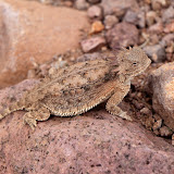
I haven't seen one of these for 2 or 3 years. I wouldn't have seen this one if he hadn't moved.
A little while later, I saw this one. Again, I wouldn't have seen him if he hadn't moved.
I saw 2 horned lizards on this hike. I don't think I had seen one for about 3 years before this year. I've seen 4 so far this year. I look around every time I pass a big red ant ant bed but if the horned lizards aren't moving, they are hard to see. Both of these were close to ant beds (they eat the ants).
Find the horned lizard in this picture. I have trouble seeing him and I know where he is. This is zoomed to how the scene would look if you were standing on the trail. You need to look at the picture full size, though.

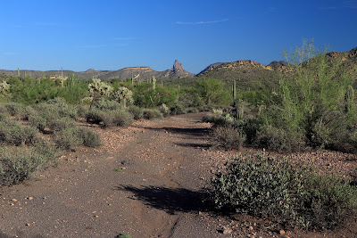
There were some rain clouds in the distance. After 11 years in the desert, I knew I didn't have to worry about getting wet.

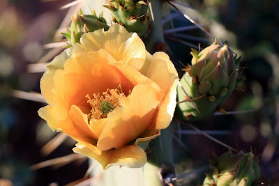
It is not unusual for a single prickly pear cactus to have 2 colors of flowers. I've seen two colors on one pad.
The rock I wanted to get close to looks sort of like a bent thumb sticking out of the ground. I had gotten pictures of it from a distance before but wanted to get closer. I was almost to the hoodoos before I thought I was close enough to the thumb to leave the trail and head for it. Unfortunately, I didn't see an easy way to get to it. I would have to go through steep-sided washes full of vegetation. I decided it wasn't worth the effort. Since I was almost at the hoodoos, I went on to them.

Nice-looking clouds over picturesque mountains.

Thumb rock. I still don't have a good picture of it.

I always seem to use that pointy rock as a gauge of how much I've climbed when I'm on this side of the mountains.
I didn't feel as tired when I got to the hoodoos as I remember being the first time I was out there. I sat in their shade and had a snack. I looked at all the other places I've explored since the last time I was out there and decided that I need to go to some of them again because they probably aren't beyond my reach now after all.

I like the view from up there.
Click below for all of the pictures.
![]() |
| 2014_04_19 |
Sunday, April 21, 2013
Just wandering
I found Sneaky Pete's final resting place.
The prickly pears have bloomed.
It has amazed me for years that I have never gotten a thorn stuck in my foot. I get cholla balls stuck to my shoes all the time, but a thorn hadn't gotten through to my foot until this hike. I was walking along what used to be an ATV trail when something stabbed me in the arch. I sat on a rock to get the thorn out, but it was a small rock and so I got stickers stuck all over my pants legs. Sitting down in the desert must be done very carefully.
That stuff covering the ground around this hedgehog cactus is full of stickers.
I find the desert scenery to be very relaxing.
I was looking for something interesting to photograph and decided to get a closer look at a rock outcropping. The sun had dipped below the Goldfield Mountains by the time I got to it, though.
The sun set on the rocks by the time I got there.
A hike in the desert is never disappointing. There's always something interesting or something pretty. Click below to see all of the pictures.
![]() |
| 2013_04_14 |
Saturday, April 20, 2013
Ant Hill, and the accelerating passage of time
Brittlebush flowers on a hillside.
I drove into Bulldog Canyon at the Cottonwood entrance. It's probably the least scenic entrance but I knew there were a lot of flowers in that area. Also, it was kind of a cloudy, dreary day so I didn't think I was going to get any great pictures anyway. I went to the top of a hill near the road and stood up there for a while enjoying the view and taking some pictures.
I made a 360 panorama while I was up there.
I've heard that time passes quickly for older people, but it's getting ridiculous. By the time I get a batch of clean laundry put away, it's time to start another load. By the time I get the groceries put away, it's time to go to the store again. By the time I get the last fingernail cut, the first one needs trimming again. It's like that old saying; The faster I go the behinder I get.
I saw something from the top of the hill and went to investigate. It turned out to be a mining claim marker. Dangit, I had just filled my pockets with gold nuggets. Oh well, all that weight was making it hard to hike, anyway.
I found a mining claim marker. It had paperwork in a bottle taped to the pole. The paperwork was wet and see-through but I tried taking pictures of it. Then I wandered around a little. I kept looking at a larger hill to the north and arguing with myself about climbing it. Then I spotted a hole in the rock near the top. That settled the argument. Off I went.
I seem to be obsessed with finding rocks with holes in them.
I took a lot of pictures of the "arch", trying to get a good one. Those things are frequently not well-positioned for pictures, though. Getting pictures was complicated by something else, too. Arizona has large red ants. Texas used to have them but I think they were run off by fire ants. Anyway, they are all over Arizona and I hear that their stings hurt but they are not aggressive and I've never been stung by one. I'm careful not to stand still where there are a lot of them. There were a lot on this hill, though. Their nests were more closely spaced that is usual. It was warm so they were out hunting for food. Every time I stopped to rest on the way up the hill, I had to look around for a spot that wasn't in one of their trails so I could stand still. It was hard to get the angles I wanted for pictures of the arch because so much of that area was crawling with ants. I decided to name that hill "Ant Hill" because of all the ants.

The sun made a feeble attempt at coming out.

I got back to the truck about the time the sun set.
I'm wondering if by the time I click the publish button, will I be complaining about the summer heat or will I already be back to complaining about the winter cold (which didn't seem as cold last winter, probably due to the extra insulation I've packed on). Click below to see all of the pictures.
![]() |
| 2013_03_29 |
Monday, April 01, 2013
From the Jacob's Crosscut trailhead to the Massacre Grounds trail
I was wondering if I would be able to find the trail when I bumped into this sign.
The trail is marked frequently with cairns but is well-worn now and would be easy to follow without the cairns. I was there kind of late in the day (on a weekday) so I only followed it as far as the beginning of the Massacre Grounds trail.
There's plenty of nice scenery along the way.
The trail is easy to follow, at least in the spring when it's lined on both sides with green.
In the middle of a stand of cholla.
I took lots of pictures of the Superstition Mountains.
I'll have to go back with more sunshine to see if I can make it to the end of the trail. The move adds a mile each way to the hike. It's an easy mile but my joints complain about long distances these days. Click below to see all of the pictures.
![]() |
| 2013_03_26 |
Tuesday, September 18, 2012
Weaver's Needle Vista Viewpoint
The paved trail takes you to this spot. The view of Weaver's Needle is mostly obstructed from here, though.
The further you go along the unpaved portion of the trail, the better the view of the Superstition Mountains.
It was a little warm out there, especially with the sun on my very dark blue jeans. There were some gnats, too. Most of them just flew around the brim of my hat. I also seem to have gotten a couple of mosquito bites while out there. They would be my seventh and eighth mosquito bites since moving to Arizona over 9 years ago. I can't figure out how people manage to get West Nile in this state.
I like the way this turned out. Can you tell what's different between it and the last 40,000 or so pictures I've taken?
I finally got to an unobstructed view of Weaver's Needle, about a mile from the trailhead. Shortly after that I came to the overflow parking lot for the First Water trailhead. Since I've seen that area recently, it was time to turn back.
I wasn't on an official trail. There are random trails wandering all over the place out there. I decided to take a different one on the way back, thinking it would re-connect with the trail I had been on before. It quickly became obvious it wasn't going to work like that, though. I was headed well south of where I had been before. I had plenty of water and was in an area where it would be darn difficult to get lost and I could always get to Apache Trail to escape.
I was almost to Apache Trail when I decided to cut across some hills to get back to the truck. I was doing a lot of pointless ups and downs but there was some interesting scenery along the way.
One of many mining claim markers in the area. These guys aren't Hispanic, or can't spell, or both.
I spotted the truck and was about to descend to a wash when something on the side of the hill up ahead caught my eye. I was tired and it was getting late, but I couldn't resist going to see what it was.
What are those white and black squares all about?
It didn't take much more clambering around to get to it. Turns out it was an old mine shaft, going straight down for 20 or 30 feet.
I hear that there are thousands of these all over Arizona. More numerous than mosquitoes, apparently.
Click below to see all of the pictures.
![]() |
| 2012_09_16 |
Monday, May 21, 2012
Missed flowers
We still had smoke from the Sunflower fire on Saturday.
I'm going to have to come up with a different plan for getting pictures of saguaro flowers. I have a few ideas, and most of them do not run the risk of serious bodily injury.
Four Peaks hiding behind smoke, dust, pollution, and saguaros.
There were no gnats on the way out to the saguaro, but that must have been because I was fresh as a daisy and was walking into the wind. They were somewhat bothersome on the way back to the truck. I was hoping high temperatures the previous week had singed their buzzy little wings but that's not the case. Click below for all of the pictures.
![]() |
| 2012_05_19 |