Showing posts with label Bulldog Canyon OHV area. Show all posts

Monday, March 09, 2015

Dome Mountain


A view of Dome Mountain.

There are only a couple of mountains in Bulldog Canyon OHV area that I know of that have names. Dome Mountain is one of them. (The other is Lone Mountain.) It's also the highest peak there. I've thought about climbing it for years, but not seriously, because every view I had of it made it look like it couldn't be climbed without doing some actual rock climbing. I was just wandering around in October of 2010 and got pretty close to the peak and thought I saw a route to the top, but it hadn't been easy getting as far as I did and the rest of the route looked difficult, so I continued to wimp out.
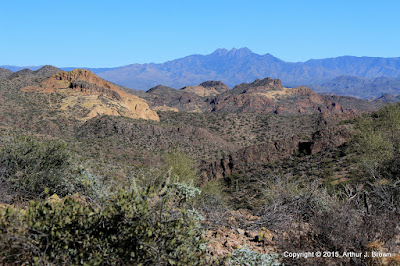

This is a view of Four Peaks from what I consider to be the halfway point. It's as far as I had gotten in 2010.

As usual, I was off work for a couple of weeks over the Christmas holiday. As is not usual, I didn't have anything but hiking planned. I was thinking about climbing Picketpost Mountain again and spending most of the two weeks gearing up to do that. I was going on long (for me) hikes with a lot of elevation gain to prepare and decided to go up to the halfway point again for the exercise. The first time I had been up there, there was a very faint trail. This time the trail was more pronounced and as I approached the halfway point, there were frequent cairns and even some white paint marks.


A cairn and a couple of paint stripes are visible in this photo.


At the halfway point.

I followed the trail up from the halfway point for a quarter mile or so, but I didn't have enough daylight, water, or snacks to go all the way to the top then. It looked like somebody had marked a trail all the way to the top, though, so I knew it could be done. I decided to concentrate on getting to the top of Dome Mountain instead of climbing Picketpost again because every time I looked at Picketpost I felt dread. Picketpost is a very steep and long hike and I wasn't looking forward to how much I would ache afterwards. I wanted perfect weather when I climbed Dome Mountain; no gloomy clouds. Perfect conditions arose on December 30.


Looking toward the Superstition Mountains from about 3/4 of the way up. There's a little haziness (pollution) in the air and it's the middle of the day, so I blame the blah-ness of the photo on that.


You can see how I really slowed down near the top in this plot of speed and elevation. It was steep and I was gasping for air. I was also going very slow in that area on the way down because it was steep and I didn't want to slip and land on a cholla.

The climb was uneventful except for the very nice views all around. I wandered around the top eating snacks, taking pictures, and relaxing until I was bored. The hike down was exciting as all steep descents on scree-covered rock are. My butt made unintentional contact with the ground only once.


The top of Dome Mountain.

From the halfway point back to the parking spot can be tricky. The cairns and paint are harder to follow in that direction. When I was up there on the 23rd I got off-trail and couldn't see how to get back to where I needed to be. I had to backtrack quite a ways. This is a warning to anybody else that heads up there. Come back in daylight and keep making sure you on on the correct route or you'll be stuck out there in the dark, which won't be so bad as long as you have a blanket and the mountain lion isn't looking for easy prey.

I made a couple of 360 panoramas from the top but they must be too many pixels. None of my viewing software can display them and I can't upload them. I'll put them on my Photosynth page someday.

Tuesday, February 25, 2014

Out for a stroll

On a sunny day not too long ago, I headed out to Bulldog Canyon mainly because I needed to get some exercise and didn't want to drive very far. I headed for a hill I hadn't climbed for a few years. I had been looking at that area in Google Earth and it looked like there was a prospect just north of the hill.


I saw my first Mexican gold poppy of the season on this hike.


The hill to be climbed is in the foreground on the left; not very big.

On the way up the hill I came across a Gila monster. This is about the fifth one I've seen in the past 11 years. I vividly remember 4 of them and I think there must be a fifth that I'm forgetting right now.


I was trying to get a picture when it had its tongue out. Missed it in most of the pictures.


Google made an animated GIF of the pictures.

I could see the prospect from the top of the hill, which was close enough for me. I think I was at that prospect about 7 years ago.


The prospect. Just another shallow hole in the ground.


This looks tame, but it's exhausting to walk across.


Somebody made a large pile of large rocks near the top of the hill. Then somebody else scattered a few of the rocks.


The usual parade of WWII planes flew over.

I decided to go down to the wash on the south side of the hill and then go upstream. I had seen a desert tortoise there a few years ago so I thought I would try my luck again. When the wash got too bouldery and overgrown to continue, I continued uphill on its left bank. Oh, no desert tortoise this time.


Cholla skeletons are beautiful.

It was a beautiful day, so I just kept walking and taking pictures. It eventually got too steep and rocky for easy walking. It looked like somebody might have marked a trail there. Maybe there's a route to the top. I'll have to go back another day to check that out, though. I didn't have enough water, food, or daylight to do it on this day.


The hill I came out here to climb is that little bump down there on the right.

Click below for all of the pictures.

BC_2014_02_09

Saturday, February 22, 2014

A favorite spot in Bulldog Canyon

There's an area in Bulldog Canyon where I've always enjoyed hiking. The past few times I've been there, though, was during gnat season. The gnats were so bad they drove me out. The other day when I was trying to decide where to hike, I figured I should go out there before the gnats got bad this year.


There was rain to the north, but I had a feeling it wouldn't get close to me.


I'm going up there.


Unfortunately, the clouds would be behind mountains for most of this hike.

It had been so long since I had been out there, I didn't remember the best route. There's only one way to get where I was going, though. The landscape guided me where I needed to go. I just went the hard way.
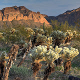

I've tried to get up there several times. Haven't found a route, yet.


A cliff edge, and the edge of the rain clouds.


The clouds look ominous. I still wasn't worried.


I've taken a lot of pictures of this view over the years.


The rocks have lots of holes up here.

It seemed to be much easier to get up there than it had years ago. I think there are a couple of reasons for that. First, I stop more often to take pictures. Rest helps. Second, I've only been up there before in very hot weather. Hiking in 100+ degree weather in a place where you can't get out of the sun is difficult.


This is a very nice view. I usually relish the breeze that blows through this spot but on this day it felt a little chilly.


I finally know how to get a halfway decent picture of the holes in that rock.


There are fluffy clouds to the south.


That rock looks almost like a mail box.

It was a pleasant, bug-free hike. I think I've climbed higher years ago than I did on this hike. It didn't seem safe to keep going. Maybe I missed a turn I had made before. Click below for all of the pictures.

2014_02_01

Sunday, February 02, 2014

Old mines

I guess you could call them mines. Is there some other name for small holes dug in the ground while looking for something valuable? I think that if they had found anything worthwhile, they would have kept digging.

There are several small mesas at the southeast corner of the intersection of Usery Pass Road and Bush Highway. I was looking for someplace to burn a few calories after work and that area is quick and easy to get to. I've been there several times in the past, but I hadn't been on all of the mesas. I headed to an area I hadn't been to before and was walking along a ridge when I looked across to another mesa and saw what looked like a spot that somebody had been digging.


The Salt River is over there.


The patrol copter.


Somebody has been digging over there.

I wasn't paying close attention when I decided to hike over to the dug-up spot, so I didn't go in quite the right direction and didn't find it. I couldn't spend much time looking because the sun was setting. Click below to open a new window with the pictures from this hike.

2014_01_22

I looked at the pictures when I got home and it was obvious that the ground had been dug up. I memorized a saguaro near the spot to use as a guide the next time I went out there, which was the next day. I easily found my destination saguaro and then the hole in the ground.


The first hole in the ground was very shallow. Yes, first.

From the hole in the ground, I could see another one a little further uphill.


The second hole was deeper and a critter had put a lot of cholla balls in it.

I went to the top of the mesa from there and wandered around a little taking pictures, then headed toward the truck. I had just started going downhill when I found another hole.


Cholla.


Sundog over Red Mountain.


Another hole. This one looks familiar.

The hole I found on the way downhill looked familiar. I was pretty sure I had seen it maybe 7 or 8 years ago. I continued downhill and found another hole that went into the side of the hill and was pretty deep. Now I was sure I had been out there before. For years I had been meaning to go back to this mine when the sun was higher in the sky to try to determine how big the inside was. I could never find it again. The first time I was out there was before I had the stuff to geotag my pictures. I had given up on ever finding it. I still need to go out there when the sun is high in the sky, though.


I think the rock dug out has this channel in it to keep the mine from filling with rain water.

Click below to open a new window with all the pictures

2014_01_23

Sunday, January 12, 2014

Back to the desert, and a suggested state nickname

I spent a few days in Texas over the Christmas holidays. About the only exercise I got for a week was chasing a small dog across a cow pasture for a minute or two. I figured I had better take it easy on my first hike after coming back. I decided to just wander around a little near the Wolverine Pass entrance to Bulldog Canyon.


There are some nice looking saguaros in this area.


I decided to climb this hill, at least part way.

I got a late start, so it couldn't be a very long hike. I headed for a hill near the parking area. I went about 3/4 of the way up and started down so I wouldn't be out there in the dark. About halfway down, I heard some distinctive engine sounds. There were a couple of WWII planes headed toward me.


WWII plane engines have a distinctive sound. You can hear them coming from miles away.


I don't think I've seen this plane before.


I don't think I've seen this one before, either.

I stood around taking pictures of the planes for a minute or two as they flew over. Then I started to move downhill again. That's when I discovered how out of shape I was. My quads cramped pretty bad.

While I was in Texas, I became aware that it was strangely quiet. The missing sound was loud Harley's. I didn't miss it. It just made me aware of how ubiquitous that sound is in Arizona. As I write this, I hear the occasional Harley go by on the nearby freeway. As you drive around town, at almost every red light, there will be a Harley stopped near you and the driver will be goosing the engine, over and over, as if it will die if he just lets it idle. Scenic routes are rarely quiet because there is a continuous stream of Harley's roaring along them. All this noise isn't the fault of Harley Davidson. It's the riders. Nobody rides a Harley without first modifying the exhaust. Anyway, I was thinking about all this noise and about the Arizona nicknames (which are "The Grand Canyon State" and "The Copper State") and figured a better nickname for Arizona would be the "The Loud Pipes State". With that nickname, visitors to the state would know they should bring hearing protection whenever they come here. Also, the Grand Canyon covers only small portion of the state, but the loud pipes can be heard everywhere, 24/7. "The Loud Pipes State" applies to the entire state, not just a piece of it in the north. Maybe I'll write to the state legislature about this proposal. Click below for all of the pictures.

2014_01_08

Sunday, June 30, 2013

Spooky Hill

It's been getting kind of hot lately, so one day after work I wanted to go on a hike for which I knew how much effort would be involved. And I didn't want to expend too much effort, so I went to Spooky Hill. You won't find that name on any maps except mine, though. I named it that years ago because the first time I hiked there, the sounds seemed very strange. Well, actually, there were no sounds. That's not too unusual, but when you make a noise, you should hear an echo. On that day there were no echos. The air swallowed up every sound I made, even the really loud ones. I whistled. It was loud enough to hurt my ears. Then it was gone. Nothing came back. Reminded me of The Langoliers. I've been back there several times since then and everything seems normal.


I think it's a pretty area out there, especially late in the day.

I took the tripod along because I was planning to make a 360 degree panorama. I put that panorama on my Panoramio page, if you are interested in seeing it. The camera wasn't level, but that was halfway intentional, because the landscape wasn't even. I got the tops of the mountains on one side without getting too much sky on the other side. It isn't obvious that the camera was tilted in the panorama. Since I had the camera on a tripod, though, I decided to get a picture of me. In that picture you can see that the camera is tilted. What's funny is that when I first looked at it, I thought that I couldn't straighten it because there weren't any saguaros nearby that I could use as a reference for vertical. I guess I don't trust myself to be vertical.


Tilted, and kind of fat, too.

I don't know if the heat affects me more these days or if I've just become more aware of its effects. I think that now I realize that when I'm struggling up a hill in the heat, I'm not struggling because I'm out of shape or because I'm hungry or something else like that. It's because it's hot, my body is having a difficult time staying at a healthy temperature, and therefore my legs feel like lead because climbing generates too much heat. Spooky Hill is small, but I stopped often on the way up, for several minutes at a time.


It looks so serene, and it is very quiet at this time of year.

I carry extra water in hot weather, thinking that if I get too hot I will pour it on myself to cool off. A potential problem with that plan is that, when you get too hot, your brain doesn't work correctly, so you may not be able to do anything about it. I think I'm just going to be extra careful the rest of the summer.

Click below for all of the pictures.

2013_06_20