Showing posts with label Bulldog Canyon. Show all posts

Monday, March 09, 2015

Dome Mountain


A view of Dome Mountain.

There are only a couple of mountains in Bulldog Canyon OHV area that I know of that have names. Dome Mountain is one of them. (The other is Lone Mountain.) It's also the highest peak there. I've thought about climbing it for years, but not seriously, because every view I had of it made it look like it couldn't be climbed without doing some actual rock climbing. I was just wandering around in October of 2010 and got pretty close to the peak and thought I saw a route to the top, but it hadn't been easy getting as far as I did and the rest of the route looked difficult, so I continued to wimp out.
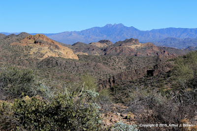

This is a view of Four Peaks from what I consider to be the halfway point. It's as far as I had gotten in 2010.

As usual, I was off work for a couple of weeks over the Christmas holiday. As is not usual, I didn't have anything but hiking planned. I was thinking about climbing Picketpost Mountain again and spending most of the two weeks gearing up to do that. I was going on long (for me) hikes with a lot of elevation gain to prepare and decided to go up to the halfway point again for the exercise. The first time I had been up there, there was a very faint trail. This time the trail was more pronounced and as I approached the halfway point, there were frequent cairns and even some white paint marks.


A cairn and a couple of paint stripes are visible in this photo.


At the halfway point.

I followed the trail up from the halfway point for a quarter mile or so, but I didn't have enough daylight, water, or snacks to go all the way to the top then. It looked like somebody had marked a trail all the way to the top, though, so I knew it could be done. I decided to concentrate on getting to the top of Dome Mountain instead of climbing Picketpost again because every time I looked at Picketpost I felt dread. Picketpost is a very steep and long hike and I wasn't looking forward to how much I would ache afterwards. I wanted perfect weather when I climbed Dome Mountain; no gloomy clouds. Perfect conditions arose on December 30.


Looking toward the Superstition Mountains from about 3/4 of the way up. There's a little haziness (pollution) in the air and it's the middle of the day, so I blame the blah-ness of the photo on that.


You can see how I really slowed down near the top in this plot of speed and elevation. It was steep and I was gasping for air. I was also going very slow in that area on the way down because it was steep and I didn't want to slip and land on a cholla.

The climb was uneventful except for the very nice views all around. I wandered around the top eating snacks, taking pictures, and relaxing until I was bored. The hike down was exciting as all steep descents on scree-covered rock are. My butt made unintentional contact with the ground only once.


The top of Dome Mountain.

From the halfway point back to the parking spot can be tricky. The cairns and paint are harder to follow in that direction. When I was up there on the 23rd I got off-trail and couldn't see how to get back to where I needed to be. I had to backtrack quite a ways. This is a warning to anybody else that heads up there. Come back in daylight and keep making sure you on on the correct route or you'll be stuck out there in the dark, which won't be so bad as long as you have a blanket and the mountain lion isn't looking for easy prey.

I made a couple of 360 panoramas from the top but they must be too many pixels. None of my viewing software can display them and I can't upload them. I'll put them on my Photosynth page someday.

Monday, November 24, 2014

The 2014 monsoon rains

We had a very wet summer in the Sonoran Desert. It was the seventh wettest monsoon season since records have been kept. People that have lived here for 30 years says it the most rain they've ever seen. All those storms mean that there were some great photo opportunities, and on a couple of occasions I was even in the right place at the right time, and even had my camera with me.


A storm moved in while I was in Bulldog Canyon. I thought I had heard a screaming animal out there a couple of days before and had returned to find the body (but the only body I found was a dead saguaro). I have since decided that somebody is hunting mountain lions out there.


Great clouds mean some great sunsets.


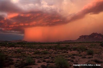
I was out in the middle of a relatively flat area south of Florence Junction when I took this. You can see dust being kicked up on the left of the photo and a column of rain on the right.


This looked really ominous. I was worried I might be trapped in mud so I hurried to pavement. Turns out the rain never got to where I had been.


I stopped to get a picture of the rain falling on the Superstition Mountains and accidentally got a lightning bolt.


There was a great sunset going on at the same time in the other direction. I kept going back and forth across the road to get pictures of both.


It looks like it's probably raining pretty hard over there.


I hung around after sunset to get some lightning pictures.


This is a normally dry wash a couple of miles east of Tortilla Flat. There were some small waterfalls there but my pictures of them weren't any good. I decided I need to get an ND filter.

Yes, all the storms were great for pictures, but there were a couple of drawbacks, too. On several occasions I gave up on taking pictures because the bugs were so bad. Mostly they were gnats but once when I was on top of Lone Mountain some termites chased me away. Termites often swarm during the monsoon rains. Thousands of winged termites leave the colony to start new colonies. They have no interest in people but when there are so many in the air at once, the can't help landing on you. After a while it's just too creepy with all those bugs in your shirt (they always seem to fall into my shirt).


Just about every day, everywhere I went, there were nice clouds. This was taken northeast of Roosevelt Lake.

The other drawback to all the rain was, of course, the humidity. I decided to get serious about losing some weight this year and was frequently climbing Lone Mountain to burn some calories. The sweat dripping off my face created my own little salty rainstorm. It was a pretty mild summer temperature wise, though. There was only about one week when it got over 110. The humidity hung around long after the storms left. It was only during the past week that it seemed to return to normal. (I noticed because my knuckles cracked and bled when I made a fist.)


Winged termites leaving the nest. Photo taken on top of Lone Mountain.


I took a lot of pictures of Four Peaks from the top of Lone Mountain during the summer.


There were more flowers than usual during the summer.

One day I thought I was going to hike out to Apache Leap, east of Superior. There were storm clouds building over the valley but I didn't think they would affect me. Fortunately, I had forgotten where the trail was and wimped out because of the humidity. A very heavy storm moved through shortly after I got back on the pavement.


Even when it din't rain, there were nice clouds around. In order to keep burning calories, I was out hiking and getting pictures several times a week.


One day I tried to drive out to White Canyon Wilderness, south of Superior. The road seemed to be badly eroded by water, but the ocotillos didn't have leaves, and the ground was dry. Seemed very strange. Couldn't get to the wilderness so I went over to the Ray mine for a look and got a picture of this storm building. It evaporated shortly after I took this.


There are horses running loose around the Salt River. I suspect they were set free there by people that couldn't afford them any more when the economy took a dive. Anyway, I see their tracks all over the place but usually only see them at the river. I was wandering around Bulldog Canyon one day, a mile from the river, and came across 3 horses. Wouldn't wild horses run away from a human? These kept an eye on me but went about their usual business.


I climbed a tall butte near canyon lake. There were nice fluffy clouds all around. From on top you can see the Superstition Mountains, Four Peaks, Saguaro Lake, Canyon Lake, and lots of other landmarks. I got a nice 360 panorama. It's on my Panoramio page.


The only waterfall I've seen since I got the ND filter is by our pool.

I've come across several things I wanted to write a blog about over the past few weeks but didn't have time with all the hiking and picture processing. Maybe I'll catch up now that the sun sets so early.

Wednesday, March 27, 2013

Familiar territory

Sometimes it's comforting to go someplace familiar. I went someplace on Sunday afternoon that I hadn't been before, but it felt like home. Well, I had been near there before, but not from that angle.


I drove by lots of flowers on the way out there.

I started hiking up a hill just to see what I would find up there. Part way up, I found a horse trail. It seems a lot of people ride their horses through there. I followed the horse trail until it got boring, which was also when I realized that I was very close to another road that I frequently take through Bulldog Canyon. Since I was climbing from a different angle, I hadn't realized exactly where I was in relation to everything else I already knew about.


I ended up going up there.

After I quit following the horse trail, I started going along the top of a solid rock cliff. That's what felt so familiar. I've done that in so many different places around here, it just feels like that's where I belong.


I walked along that rock behind the paloverde tree.

I found a hole in the rock up there. Not sure if it qualifies as an arch. It's a small hole at the base of a slab of rock. It was hard to get pictures of it.


A hole in a slab of rock.

As I moseyed around up there I recognized more things around me. It turns out that I was close to Richard's arch (I call it that because he spotted it). I was thinking about hiking up to the cliffs to the north of where I was but was relieved when I realized I had already been there a few years ago when I had hiked up to Richard's arch. I guess I'm still feeling kind of lazy since I didn't want to hike up there again.


Richard's arch is behind and to the right of those cliffs.

I stood around up there for about half an hour, enjoying the view and feeling at home. Click below to see all of the pictures.

2013_03_24

Monday, May 07, 2012

Gnats and rattle snakes

I was planning to hike up the side of a mountain in Bulldog Canyon on Sunday. I hadn't been up there for a while and I knew it would be pretty and I wanted to try to get to some places I hadn't been before up there. Before I even left the truck, though, the gnats were being very annoying. They were so bad that I wore my sun glasses just to keep them out of my eyes.


I was planning to go up there.

By the time I had gone 200 yards, my arms were tired from swatting at gnats. I had actually caught and killed 3 in my hands (which is unusual) and had smashed another 40 or 50 on my arms, but they weren't discouraged. I was, though. It was difficult to take pictures with gnats crawling up my nose and into my ears. That's very distracting, you know. It looks like it's going to be a bad year for gnats, so I'm going to have to find a solution. I'm hoping that the sunscreen my sister gave me will keep them away. I've used it twice (to prevent sunburn) and wasn't bothered by gnats at all on those hikes. I don't want to use insect repellent because I just don't like that stuff.

So I headed back to the truck and started driving slowly home. Just a little way down the road there was a snake stretched across the road. It rattled and got ready to strike when I got too close for it's comfort while taking pictures. Then it slithered away.

A little bit further and I came across another one. I'm pretty sure they are in the road to warm up (it was only about 89 out there), but this one was in the shade of a palo verde. As you can see in the video I made with my phone camera, it also started rattling before I was very close.


Western diamondback rattlesnake


The same snake on the side of the road, taken from the safety of my truck.

Then not too much further along the road, I came across a third snake. I got out of the truck to take some pictures and to shoo it away because I didn't think I could drive around it without possibly squashing it.


The third snake. This one's dangerous.

The third one never moved as I got as close as I dared to a rattlesnake. Not even the slightest rattle. As I moved around to it's other side to get more pictures the head followed me, but that was the only movement. It wasn't going to move, so I looked around for a nice, long stick. Longs sticks can be hard to find sometimes but there was a half dead palo verde nearby. I nudged the snake with the stick. It did nothing. I moved it a few inches toward the side of the road. I moved just a little. I started to wonder if it had already been run over. I was sliding it to the side when it decided that enough was enough and it gave its rattle a couple of feeble shakes and slowly slowly slithered away. I don't think it was injured after all. If I had stumbled on those first two snakes without seeing them (while hiking), they would have given me plenty of warning to avoid them. That last snake would have done nothing until I stepped on it. Then it probably would have bitten me. That would spoil the whole hike. It would probably be worse than hundreds of gnats.

I think I've come across 4 rattlesnakes while hiking (that I know of). Two rattled like crazy. Two sat there like rocks. I prefer the ones that rattle. Click below to see all of the pictures.

2012_05_06

Wednesday, January 25, 2012

Reflections

We've been having unpleasant weekend weather lately; Gray, overcast skies but no rain. During the week, we have had beautiful blue skies. I didn't even go for a hike last weekend because it was so dreary looking. I felt like I had to get out in the sunshine after work yesterday, even if it was late in the day. I wanted some nice scenery, so I headed down to the Salt River.


The Salt River always looks picturesque.

The river is very low, as it usually is this time of year. There was one other vehicle parked out there, but I never saw the driver. I wandered around for about half an hour taking pictures.


There was no wind, so the water was very calm where it was deep enough.

I found out you can have some fun with reflections on the water.


Looks like a rocky sky.


A rock-shaped UFO?


This just looks strange.


Just a picture, but I like it.

I wonder if I can get somebody to get in the water and pose for some pictures. I can think of some strange pictures to create. Any volunteers? You don't have to be a swimsuit model; just be willing to stay mostly submerged in cold water (it's even icy cold in the summer) without shivering (that would make ripples) for several minutes at a time.

While you're thinking about that, I have some great news. Bulldog Canyon OHV permits are now available online. No more "I couldn't get off work before they closed" excuses. They have also put the Bulldog Canyon OHV Area information packet online, which has a new and much more readable map, though I don't think it's quite as good as my UNOFFICIAL map.

Click below to see all of the gloriously sunny pictures.

2012_01_24

Saturday, December 24, 2011

A scenic part of Bulldog Canyon OHV area

I went back to a part of Bulldog Canyon in which I had hiked about a year ago. Interestingly, in the current (January) issue of Scientific American, Michael Shermer comes to the same conclusion as I did then regarding the computer intelligence singularity, i.e. it will always be a few more years away. I would suspect that he was reading my blog and stealing my ideas if it wasn't such an obvious conclusion. (Plus, I can't imagine contributors to Scientific American doing such things.) Anyway, I thought that was interesting. Now back to the hike.


I took my favorite picture of the outing while I was still driving to the "trailhead".

I've got a couple of weeks off of work and had all sorts of plans for places I was going to go. The time off started last Saturday (the 17th). I got out of bead early that morning, reached down to pick up my phone, and my lower back went *sproing*. I hate it when that happens. It's just as well, though. The next few days were gloomy and wet, so I wouldn't have done much hiking anyway.

This is a scenic walk down a nameless wash (intermittent stream). I'm guessing that I walked about 8 miles. Can't tell for sure because the PN-40 discarded part of my track, and it was a part where I should have had excellent satellite coverage. Well, I could figure it out, but I'm feeling pretty lazy today. I'll never count on this receiver for breadcrumbs, though. It felt like a long walk. My ankles are achy today.


I saw places I want to go explore on my way down the wash. Some day.

The last time I was down there, I took a lot of pictures of puddles. We've had a lot of rain recently, so there were even more puddles. I told myself that I had enough pictures of puddles, though, and I wasn't going to take pictures of any more puddles unless they just happened to be in a good spot and looked good. I wound up with a lot of pictures of puddles again, anyway.


I think I got a picture of this puddle the last time I was out here.

A year ago, I could see some evidence of vehicles having driven down the wash. According to the Forest Service map, they shouldn't be there. I parked at the end of the official road, which is indistinguishable from the non-road that continues to the north. In January, it looked like only a small number of vehicles had gone very far down the wash beyond the end of the road, and there hadn't been any there for at least a couple of weeks. This time, it looked like there had been heavy traffic along most of the wash and there had been multiple vehicles out there the same day I was there (though I didn't see them).

I "hurried" at the beginning of the hike because I wanted to get to the view of the cliff that I like so much while there was still sunshine, and I had gotten a late start (long story). It seemed to be further to that cliff than I remembered, but it was just as pretty.


My primary destination.

After getting more pictures of the cliff, I had enough charge in the camera battery and enough sunshine (or so I thought) to continue downstream. Along the way, I found a small natural cave in a canyon wall. It was pretty dark in there, but I made a movie. There were what looked like fresh tennis shoe prints in the dust on the floor of the cave, but water doesn't get in there unless there's a huge flood and it's probably difficult for wind to blow through there, too.


From one end to the other of a small cave. Surprisingly, the PN-40 did not choke to death while I was in there.

I went all the way to where the wash intersected another wash that is very popular with ATV and 4WD enthusiasts, but is also not an official road. From the cliff to the other wash was rough and slow-going. I noticed a few things about plants that grow in stream beds there, too. There are almost no cacti in stream beds. There are many types of plants there that have no thorns. Some have thorns, but you can brush bare skin against them without getting a scratch. Then there's catclaw acacia. It's thorns are curved, like cat's claws. It takes just the slightest touch, and the claw grabs you. If you move, more claws grab you. If you move more, they sink in and rip flesh, so you don't want to pull away from one because it will rip you to shreds. You have to move towards it to get unhooked, but that just allows more claws to make contact, and they aren't going to let go easily.

The harmless plants are scattered here and there. You could brush up against them if you wanted too, but you almost never have to. Even when you get to a choke point, where there is only one possible route through, there are rarely harmless plants there. Those special places seem to be reserved for catclaw acacia. So you're clambering over slippery rocks and trying to avoid falling in a puddle and you have to drop the last foot or two and guess what grabs you just as you start to drop. Every time. Riiiiip rip rip rip riiip rip. Usually, I try to ignore the results, unless the blood runs down to my fingertips. Then I try to keep from getting blood on my camera. What adds insult to injury is when pesky gnats move in to feast on the blood. Fortunately, there were no gnats this day. I often get home from hikes and pull catclaw thorns out of my arms as I shower. I guess the best thing that can be said about catclaw is that, once it's embedded in your flesh, it doesn't release chemicals that cause pain (the way rose thorns do).


Catclaw got my nose. Ouch.

The sun had set by the time I got back to the cliff that was my original destination. It was quickly getting too dark for pictures, so I didn't have to stop to take many more. I was getting tired, though. My legs ached. I concentrated on moving steadily ahead, without stumbling. I didn't want to look like easy pickings to a hungry cat. I had to squat down occasionally, though, for a short rest and to stretch the muscles that were aching. This is when I discovered an advantage to having hurt my back a few days earlier. I had to keep my back straight up and down. That meant that any time I needed something off the floor, I used only my legs. It's surprising how much stronger they had gotten from a few days of picking up newspapers, dropped items, and Emily like that. My legs never got tired of pushing me uphill on that hike.


I like the way some pictures taken in the dark turned out.

After a while, it got hard to see any detail in the bed of the wash. No moon. I could tell where water was, where sand was, and where solid rock was, but that was about it. The solid rock became dangerous to walk on, because I couldn't see the ripples in it, and I wound up stumbling a couple of times. I had to resort to using a flashlight. I used the one my younger sister gave me a few years ago. It's a single LED. Bright enough to see the texture, but not so bright as to destroy my night vision. It was perfect. I got to the truck about 150 yards after getting the flashlight out. Click below to see all of the pictures.

BC_2011_12_23

Sunday, November 20, 2011

Yet another gloomy day

Remember how gloomy it was last Saturday? There isn't any rain in the forecast until Monday, so I wasn't worried about rain yesterday. We had the exact same pattern of clouds moving in from the southwest, though, and by the time I got out to Bulldog Canyon, the sky was grey.


The Supes on a gloomy day.

I didn't want to drive a long way on Saturday, so I headed for Bulldog Canyon. As I approached the Wolverine Pass entrance, I remembered the guy that didn't have a pass the last time I was out there and all the knuckleheads that break the lock and tear up the desert in that area and thought about going someplace else. I had about decided to turn around when I saw a ranger at the gate. He was checking passes as people entered. Hallelujah. It was good to see them doing something about the knuckleheads.


I'm going to walk up there somewhere.

The people that had passes and got in still drove places they weren't supposed to, but I won't get into that now.

I planned to go somewhere I hadn't exactly been before, just to see something slightly new. I headed up the side of a mountain. Part way up, I thought I could see a wall built near the top. I zoomed in and took a picture, and zoomed in on that and decided that maybe it wasn't a wall, but decided to wander in that direction until it got impossible or I got tired.


Does that look like a wall to you?

I kept thinking I should stop and turn back, and then I would think about looking at the pictures when I got home and realizing that it was a wall and I needed to go back up there to check it out, so I kept going. Eventually, I got to a point where it was getting dangerously steep. When I'm putting my hands on the rock as I'm climbing up, it's too steep. Fortunately, I have decided that it's just rock and not a wall.

On the way down, I saw an air rescue helicopter fly over. I think it had come from somewhere in the Superstition Wilderness. I wonder if a hiker ran into trouble out there. I guess it could have come from the twisty road by Canyon Lake, too.

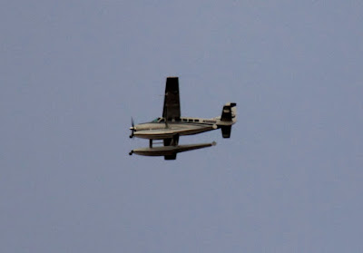
I also saw a plane with pontoons. You don't see those very often in Arizona.


Your landing options are somewhat limited in Arizona with this plane.

BC_2011_11_19