Monday, August 29, 2011

Wandering the desert, in air conditioned comfort

I left the house on Sunday morning for the vicinity of Roosevelt Lake, planning to get some more Photo Point pictures. There had been some storms around Saturday evening, but I didn't see much dust blowing around then. It was so dusty on Sunday morning that I couldn't see the Superstition Mountains from 9 miles away. Dust that thick when the air is calm is unusual. Even if it had been a cool day, I wouldn't have gone hiking in dust that thick. Still, there were a lot of people out on the local hills and riding bicycles before the day got too hot. There was a lot of dust in the air almost until I got to the valley where Roosevelt Lake is located. I didn't take any pictures of the dust because that seemed silly. "Look at all the stuff you can't see in this picture". Ha. I guess I could have shown it with a picture of the same scene under clear conditions, but that seemed like too much work.

As I approached the first photo point, I reached for the notebook with the descriptions and reference photos and realized that it was still at the house. Dad gummit! Well, there was only one thing to do. Drive around and take pictures of stuff (it was too hot to hike).


This lizard seems to be upset about what has been left on its rock.

I got out of the truck now and then to wander around a little. One of those times, I walked out to an overlook of a wash. Suddenly there was a lot of clattering down in the stream bed. I had startled a couple of deer and they were noisily scrambling to get away. Deer look graceful when they are soaring over a fence or a bush, but if you have ever watched one that's in panic mode you know that grace is the furthest thing from their mind. That's understandable. I wouldn't be very graceful if I thought something was about to eat me. Anyway, I think maybe the pair was a doe and fawn. I quickly lost track of the smaller one and took pictures of the other one as it jumped and snorted and climbed the hill across from me.


Seems kind of skinny to me. What do you think?


I wandered around on the west side of the lake first. To get a good view of the lake, I would have had to climb a hill. Too hot to do that.

The last time I was out there, I had driven a little ways on A + Cross road. That's how it's written on signs, but it's pronounced "A Cross". I've been wanting to drive the length of that road for 4 or 5 years. So that's where I headed. The road is in very good shape, and there aren't any steep parts. There are interesting things to see along the way, too.


Barren hills. This is what you expect a desert to look like. Well, except for all that green stuff in the foreground.


Dutchwoman Butte really stands out from far away.

When I started out on A Cross road, I thought I might also drive up 288 to Young, but by the time I got to 288 I'd had enough beautiful scenery for one day. Instead of turning left, I turned right and headed for Globe, to the south. I had come into the valley from the north, near Payson, so I would have some different scenery on the way home. As I approached Globe, it looked like a puffy little cloud was dropping some rain. It looked like diffuse, gentle rain like you seen in Texas sometimes. I finally realized that I was looking at dust, though. There was a lot of it in the air all the way back to Mesa. I'm glad I got out of it for a little while. Click below to see all of the pictures.

2011_08_28

Sunday, August 21, 2011

Armer Gulch and Cottonwood Wash

I haven't taken any Photo Point pictures for a while. I decided to try to get out to a couple of them early Saturday, before it got too hot. It's a long drive, though, so I didn't get there very early. I was heading for Armer Gulch and Cottonwood Wash, just east of Roosevelt Lake. Another reason I wanted to go to that area was to get a look at Parker Canyon from the east.


Every time I've crossed the Salt River before, I've thought that I should stop and take a picture. Can't remember if I ever did, but it would have been nice for comparison. I don't think I've ever seen it so muddy.

I stopped to take some pictures at the Salt River. It was about 92 then and felt pretty good. I was thinking it might be pleasant as I took pictures at the photo points. Silly me.


There were puffy clouds to the east when I arrived.

I got to the side "road" that went to the first photo point and was supposed to follow it for half a mile. I remembered to look at the tripmeter. 82.1. There were lots of mesquite and cat claw branches intruding into the path. I dodged this way and that trying to avoid them, but was not very successful. After going through dozens and dozens of branches I checked the tripmeter to see if I was almost there. 82.1. I parked and started walking.

I had to climb a little to get into position for the first pictures. I had reference pictures with me that I had to match. A rock ledge lined up with distant mountains in one picture and a saguaro lined up with a road in the other showed me exactly where I needed to stand. I needed to stand in a place that, if I was out hiking just for fun, I would not have gone. It was at the top of a steep slope of loose dirt. If I slipped, I would probably go all the way to the bottom. At least there was a bottom. The dirt was very soft, so each time I put a foot down, I carefully let it sink into the dirt and made sure it couldn't slide downhill. I was wondering why that spot was picked and remembered that it was picked 20 years ago. I probably would have thought it was a good spot 20 years ago, too. I was still pretty much invincible then.

The climb and descent got me warmed up. There wasn't much of a breeze, especially once I was back down in the mesquites. I trudged back to the truck and started looking for the second photo point. Turns out I parked about 50 feet from it. A cottonwood in a reference picture was still there, but it was dead and will be gone soon.

I decided to trim some branches before driving out. I didn't cut very many, and my saw worked quickly, but the exertion and being in trees too thick to let a breeze through but too thin to block the sun just about fried me. I was able to drive to the third photo point.


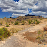
Armer Gulch; a river of green flowing to Roosevelt Lake

After getting the last Armer Gulch pictures, I decided I needed to do some serious cooling off. I didn't know if I would even try to get any more photo point pictures. I wandered around (in the truck) trying to find a way to Parker Canyon and eating food bars and drinking water and drinking water. No, I didn't stutter.


I came across this while cooling off. The inside is about 4 feet by 5 feet. I can't imagine what it was for. It looks like it had a sturdy door, but that's been destroyed.


This narrow canyon is formed by Parker Creek. I'll get some pictures from the bottom when it's cooler and less likely to rain.

There were clouds building to the east as I drove around. I could see some rain and heard a little thunder. If it started to rain near where I was, I would just have to sit in the truck and wait. I'm sure there would be lots of water going across the roads. I wasn't going to worry about it, though. I'd cross that bridge when I came to it. Ha ha. Groan.

The road I was following toward Parker Canyon got worse the further I went, but I was able to keep going, so go I did. I came to a spot with several tall cottonwoods. A side road off the side road went into the middle of lush greenery. The ground on the sides of the side side road was solid berry vines. It was like a dark jungle in there.


A dense jungle in the desert.

There was a convenient place to park near the side road (which, strangely, was covered in a think layer of ash), so I parked and headed into the jungle. It was eerie. The eeriest part was a chain link fence at the end of the road. There were no tracks, no trail, just plants on the other side of the fence. Suddenly I heard "Hotel California" playing in my mind. It was just too creepy. I left.


You can check in, but you can't check out. I made like a ballerina and split.

After driving around for a while, I was cooled off and feeling pretty good. The clouds were also providing some shade so I decided to take pictures for the Cottonwood Wash photo points.


Cottonwood Wash, with Parker Canyon in sunlight in the background.

I walked up and down Cottonwood Wash several times looking for the first photo point. The reference pictures had no distinguishing reference points. No mountains in the backgrounds, no huge boulders, no steep banks. I couldn't find anything that looked as plain as the reference pictures. I was getting hot again, too. The clouds were dissipating. I was also getting tired since I hadn't had much of a lunch. My documentation has coordinates so I resorted to putting those in my GPS receiver. They took me to a spot that looked a little like the reference pictures; a rocky wash. Actually, the coordinates took me out of the wash, far beyond what typical GPS error would have done. I got close to the coordinates but stayed in the wash and took pictures. The next photo point was like that, too. If I hadn't had coordinates for the third, I would not have found it for weeks from the description. There were large cottonwoods there that matched the reference photos, so I knew I had found the right spot.


At one of the Cottonwood Wash photo points, I had taken my sunglasses off to take pictures and never picked them back up. At least I think that's what happened to them. I guess they could still be in the truck somewhere, but I can't find them. I'm glad I buy really cheap sunglasses. That pair had already lasted longer than most.

Several times while I was out there I searched for the tiniest bit of shade and stood there panting in the heat. It was very uncomfortable. Part of the problem is that I wear bluejeans. Very blue jeans. They soak up heat. Several times I've gone to stores planning to buy some thin, light colored pants. All the stores I've been to only have light colored pants for short, fat guys. What's up with that? Do the short fat guys run all the light colored pants factories or something? Well, I may have been uncomfortable, but I still had fun. I saw lots of cool stuff, too. I'd do it again. I will do it again. Click below to see most of the pictures.

2011_08_20

Monday, August 15, 2011

Still too hot

For hiking in the middle of the day, that is. I had stuff to do in the morning and plans for the late afternoon, but I had to spend some time in the desert so I went in the middle of the day. I went out near Fish Creek Hill and was thinking I might take a short hike over to where I could see Apache Train descending the hill. It would be less than a mile round trip.


I couldn't drive as far as I wanted on this road, but I didn't need to go far.


There were signs of recent rain.

As you might guess from the clouds, the humidity was up. It was only about 100, but the intense sun and the humidity made it uncomfortable. There are very few saguaros up there, probably because of the altitude (about 3000 feet), so I couldn't hide in their shade. Clouds got between me and the sun now and then and that was very nice.


Apache Trail is over that cliff and 600 feet straight down.

I was kind of wandering in the general direction of where I wanted to be, with my exact direction of travel determined by what I wanted to get a closer look at and what the terrain would allow. I got within about 400 feet of my destination and stopped to take a few pictures. I looked around vainly for a place to get out of the sun and I studied the studied the slope ahead of me. I would have to descend 100 feet. It was mostly gradual, but there were occasional vertical drops of up to 8 feet. You can usually get around those, but it takes time. After considering the effort it would take to get to the cliff edge, the rate at which I was drinking water, and the fact that the return trip would be all uphill, I decided that it was time to turn back.


That's Four Peaks from the side way back there.

I had made stops on the way down to plot my course. I had to make stops on the way up to keep from overheating. I felt like a wimp when I decided to turn back but halfway up I knew I had made the right decision. By the time I got back to the truck I was getting a headache. Turning back had been a very good decision.

Whenever I have to postpone getting to my intended destination, I think about all the motivational speakers I've listened to saying that you have to set a goal and stick to it. I'm pretty sure that it would be foolish to apply such a philosophy to hiking in the desert. Or maybe I should just add "and return in good health" to my hiking goals. Click below to see all of the pictures.

2011_08_14

Wednesday, August 10, 2011

Sunset pictures

The clouds we have this time of year often make for some stunning sunsets. I watched a couple from the yard but I've given up on taking pictures of them from there. Can't stand all the houses and light poles in the way. I used to drive out to the desert 2 or 3 times a week to get sunset pictures but I finally got tired of not enjoying them. It's been a while since I've taken any, so yesterday I headed out to Bulldog Canyon to go for a short hike and photograph the sunset.


I got out there just before the sun set.


The moon was up.


It was a nice sunset.

I didn't see much wildlife. Just rabbits and birds. I was next to a deer trail, but I didn't scare off any deer. There was only 1 fly and no gnats. Boy, that was nice. Click below to see all of the pictures.

2011_08_09

Sunday, August 07, 2011

Exploring roads

I wanted to go for a hike yesterday, but couldn't decide where. I eventually wound up exploring roads branching off of Kelvin Florence road. I went down several roads where my progress was stopped by gates (there are several ranches out there) or by terrain. Often, I couldn't turn the truck around when I needed to, so I had to back up a long way. My neck still hurts.


Barrel cacti have yellow flowers near where I live. This is a nice change.

It seems that Cochran road and Whitlow Ranch road are about the only roads that go all the way up to the Gila River. Whitlow Ranch road goes up to where all the water is taken from the Gila River and put in a canal. I didn't make it to the end of the road, though, so I couldn't see that.


I came across a very strange looking saguaro.

I uploaded the full size panoramas to my web album this time, instead of all the individual pictures. If you zoom all the way in and then wait a few seconds, you should be able to zoom in a lot more. Click below to see all of the pictures.

2011_08_06