Wednesday, December 29, 2010

Back to Bulldog Canyon

A couple of days ago, Sweetums and I took the Ranger to the part of Bulldog Canyon OHV area that isolated from the rest. There is one road, and that road doesn't connect to any others. Since it was a week day I didn't expect to see a lot of people out there. We had to park and wait as about 6 jeeps went by in the other direction at one point, though.


I'm used to my legs being worn out by the time I get here.


This is the official road, but it isn't used much.

Most of the road is not very rough and I drove slow over the rough spots. Sweetums appreciated not being jostled so much. She tried getting pictures and movies of what we were driving over but, as usual, pictures don't show how intimidating some of the stuff we drove over is. We'll figure out how to do that eventually. Click below to see all of the pictures.

BC_2010_12_27

Tuesday, December 28, 2010

The top of a hill

I haven't been hiking much lately. I've mostly been riding around in the Ranger. My sister might have been right; I'm going to get fat. I decided I had better go climb something. I headed for a very scenic part of Bulldog Canyon. Along the way, though, I realized that I didn't like the way the clouds looked, and I didn't want to take pictures of a scenic area with bad clouds. I stopped at the part of Bulldog Canyon that was burned by the Ghost Fire in the summer of 2005. It's still a pretty desolate looking area.


There are few saguaros, but lots of saguaro skeletons.

I started climbing a fair-sized hill near the road. About halfway up, I heard a voice. I knew it wasn't God because it sounded like it was coming over a PA system. I've heard hikers talking up to half a mile away when they're on the side of a mountain, but the wind was blowing the wrong way for the sound to be coming from any nearby mountain sides. Also, hikers don't use PA systems either. Then I remembered seeing Apache Trail Tours Jeeps in this area before. They do use a PA system. Sure enough, one of their Jeeps pulled into view pretty soon. It stopped. They do that sometimes so people can take pictures or talk about something by the road or quell their motion sickness (that's bound to happen sometimes on those roads, even though their drivers seem to go at a very safe (and slow) speed). I zoomed in and took pictures, but they were too far away for me to tell what they were doing. I ambled on up the hillside.


Apache Trail Tours.

As I neared the summit, the hill got steeper. They tend to do that. It got steeper than I wanted to climb or descend. The Jeep was still there. I don't know if they saw me, but if they had stopped to watch me I sure didn't want to slip. They had been sitting there for a long time by now and I wondered if they had spotted me and were curious about where I was going. On the other hand, if I couldn't tell what they were doing when I had my camera zoomed all the way, it seems doubtful that they had even noticed me. Still, I didn't want to fall on a cholla in front of an audience. I worked me way round to the right and the hill got even steeper in that direction. I was on my way (very carefully) around to the left and had just spotted a way to the top when the Jeep started moving again. Whew. I could relax.


There were more people on the other side of the hill. I'm sure they never saw me.


The view was nice, but not stunning.

While I was up there, I took a 360 degree panorama and put it on my Photosynth page so you can view it full screen and zoom in and all that stuff.


360 degree view from the top of the hill.

Click below to see all of the pictures.

BC_2010_12_26

Tuesday, December 21, 2010

Taking the Ranger to Bulldog Canyon

I've wanted to drive along 10 from one end of Bulldog Canyon OHV area to the other for a while. I knew the Ranger could do it. I should have known better than to take Sweetums on that trip. I had forgotten how rough much of that road is. Also, she seems to be getting a sinus infection, so she wasn't feeling great to begin with.


The ride was very smooth until about here.


Next time I'm out there I'm going to take some pictures of the rough spots.

It took about 2.5 hours to go 10.7 miles. Parts of the road have been washed out and are pretty scary. I need to pick a smoother road for our next trip. Click below to see the pictures.

BC_2010_12_20

Sunday, December 19, 2010

New ride

I have found a way that my Sweetums can enjoy at least some of the stuff I see out in the desert. Well, actually she found it. On a recent trip to visit her sisters in Texas, she saw the Polaris Ranger 400 recently purchased by the husband of one of her sisters. She was hooked. We looked at them for a couple of months and decided on getting the Ranger Crew 800. I picked it up Friday and we went riding at The Rolls (near Four Peaks) yesterday.


Sweetums in the Ranger Crew 800.

It seats 6. I'm going to have to learn to be sociable so we'll have friends to take with us.

It was raining when I got up yesterday morning and I didn't think we would be able to go riding, but it cleared up a little. The remaining clouds made for some interesting pictures. Everybody says the rain shouldn't stop me. I could put the top on, but I just don't like driving with rain hitting me in the face.


Stewart Mountain

I got the half windshield and I'm glad I did. It keeps the wind off but doesn't obstruct the view. People I had talked to about the ride said it was very smooth. It is smoother than the truck but I still don't think I would describe it as "smooth". Maybe if I went fast enough we wouldn't feel all those little bumps. I started to drive along a road that goes into the middle of the Four Peaks Wilderness but it was very rough. I turned around before going very far because I was getting tired of being jostled. We had been riding for a long time by then. It was also getting late and I wanted to get back to the truck before it got too dark.


Four Peaks. No snow.


It was a beautiful day. In the middle is the road into the Four Peaks Wilderness.

The only problem so far is storage. I thought I would be able put it on the trailer in the garage. That didn't work, though. The trailer is bigger than the one I used to have in there, so I can't put the motorcycles where I used to, so they take up a spot where I used to have a car. So we used to be able to put two cars in the garage but now we can't put any. We typically have about 5 and as many as 7 cars at the house. Our neighborhood has a silly "safety" rule about not leaving cars parked in the street, even though the streets were made wide enough to accommodate cars parked on both sides and a firetruck down the middle.


Looking back from the road in the wilderness. The clearing in the low spot is Cottonwood Campground.

I was impressed with how the Ranger seemed to be able to go anywhere. It went up some pretty steep spots and I never heard a tire slip. I'm going to be able to drive along all those roads where I had to turn back before.

2010_12_18

Monday, December 13, 2010

Wandering in Willow Basin

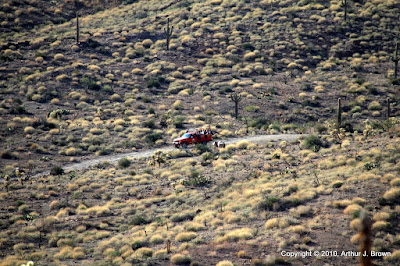
Willow Basin is on the eastern edge of Bulldog Canyon OHV area. It has one OHV road and that road does not connect to any other part of the OHV area. There usually aren't many people out there, but I saw several groups on Sunday.


It probably feels like winter in the rest of the northern hemisphere. It was 79 here on Sunday.

I started out following a wash instead of walking on the road, because the wash doesn't go up and down as much. Also, there was less traffic (until the wash merged with the road). Walking in fine, loose gravel is tiring, though. It was very pretty in the wash for a while. Also, there was a pipe running along the side of the wash. Must have gone from a spring to a stock tank. It was very wet near where one end of the pipe was. I wasn't paying much attention and didn't notice where the other end was.


Plumbing in a canyon.

There are a couple of former roads out there that I wanted to follow to their ends. I say former because they aren't on the Bulldog Canyon map. People still drive on them. By the time I got to where the first one might be, I had forgotten exactly where it might be, so I started wandering across the desert. That's always fun. You never know what you'll find. First, I found a Pepsi can, almost unreadable because of having been bleached by the sun. Then I found a Coke can, just as bleached. I picked up and third can and was turning it slowly in the sun, trying to find a faded marking I could recognize. At first I was startled to realize it was a Budweiser can, but then realized that meant I was close to the "road" I was looking for. Only one time in seven years of hiking in the desert have I found a beer can more than tossing distance from a road. Generally speaking, people that are too lazy to properly dispose of an empty beer can are also too lazy to walk very far from a vehicle carrying all that weight.


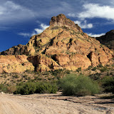
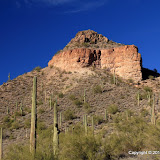
Near the end of the first former road.

I started going around the butte in the previous picture, on my way to the second former road. I was getting a little tired, though, and was thinking about heading straight back to the truck. I came to a small canyon I couldn't cross and decided to follow it to the road. I hadn't gone far when I heard a dirt bike behind me. Well, I had just found the road, so I turned around and headed for it.


A saguaro strikes the classic "stick 'em up" pose.

That road ended in a steep climb; so steep that the ATV following the dirt bike didn't climb it. Well, it did have two people on it. I think the woman on it must not get out much. She was complaining about the mosquitoes. The gnats and flies were being pesky, but I haven't seen a mosquito for a few weeks. Anyway, they were talking about the wonderful weather and the great view from up there and they asked me if I ever hiked in the Superstitions. I was telling them about various trails and started talking about the fantastic views from the tall mesa to the northwest and about the trail going up there. The kid (maybe 14, he was on the dirt bike) looked entranced. He's probably pestering his dad to take him out there now.


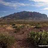
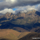
I have plans to never climb to the top of this. I've seen it from all sides now, and none are climbable by me.

As I was walking from the first former road to the second, I kept hearing sirens on Apache trail. I could even see some fire trucks and sheriff's SUVs heading towards the lake. After about 15 minutes of sirens, a life flight helicopter headed out there and then flew over again on it's way back to town about 45 minutes later. I kept thinking about how distressing it must be to be laying on some rocks at the bottom of a cliff listening to those sirens and knowing they're coming for you. Well, it's good that they're coming, but it would be a bummer to be in that situation.


I've been up there. The view is great.

When I was just getting back to the truck, I heard some voices. I looked around and spotted the kid scrambling up a large rock. I could hear him telling his parents that it isn't as steep as it looks and he's being careful. He got to the top about the time I got to the truck. I took a few pictures before putting the camera away.
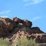

He's hooked.

About the time I got to the gate, the kid came up behind me on the ATV. He was talking about his climb and about how tired his legs got because he went fast. He sounded excited. I think he's hooked on climbing things to check out the view. I can relate.

Click below for all of the pictures. There are a couple of panoramas in there but they are scaled down. Go to my Panoramio page (link on the right) to see them full scale.

BC_2010_12_12

Monday, December 06, 2010

Richard's arch

I think I've mentioned this arch recently. Richard was with me the first time I saw it, so I call it Richard's arch. For years I've been saying I was going to hike up to it some day. On Sunday I was trying to decide where to go hiking and decided it was a good time to climb up to that arch.


On the drive to the arch I passed by this old stone foundation. I wanted some geotagged photos of it. On maps this is marked as "Rock House".


There is also a well next to the house. As far as I know, it always has water in it.


I like the rocky landscape out here.

It didn't look like it would be a difficult climb up to the arch, and it wasn't. It was very nice weather for a hike, too. There were some high, thin, but interesting clouds around. There were several trucks and ATVs at on the road at the Wolverine Pass entrance and a couple of vehicles were parked near where I was hiking, but it was very quiet. I didn't hear anybody roaring by the whole time I was out there.


The view to the north as I started up. I've been out that way a few times.

It didn't take very long to get to the arch. Of course, I had to stop a lot to take pictures. At one point after climbing steadily for a couple of minutes, I had to duck under some paloverdes, then took a few quick steps uphill to keep my balance, then just kept going to get to an easier place to stand. I climbed about 20 feet in a quick burst and my legs felt tired. It reminded me of chasing Emily (17 months old) up and down the hall just to hear her giggle. Kids can wear you out fast.


At the arch. That's Four Peaks in the background.

I guess it's more of a rock wall with a hole in it than an arch, but what the heck. I hung around there taking pictures for a while and put my camera in manual mode for a couple of pictures and accidentally left it there for most of the rest of the hike. Fortunately, most of the pictures were salvageable.


The arch from the other side.

I climbed a little higher from the arch to check out the views to the east and south. There's a good view of the Superstitions. The air was kind of hazy. It's "brown cloud" season. The wind doesn't blow, so air pollution just piles up in the valley.


A view of the Superstition Mountains.


Dave and I were on that cliff on October 5th.


This is the view from that cliff looking back towards the arch.

It's always fun to stand on various peaks and look around at other places I've been out there. I also often spot other places I need to go. Click below to see all of the pictures.

BC_2010_12_05

Monday, November 29, 2010

First Water Creek via Black Canyon

Saturday was a beautiful, cloudless day. I had to do some shopping that day, though. I was at the computer Sunday morning thinking about where to go hiking and thinking that it seemed unusually dark outside when I heard rain on the windows. It looked like I would be driving around looking for waterfalls instead of hiking, though it didn't seem to be raining hard enough to get any waterfalls flowing. It did clear up some, though. After lunch I decided to hike down to First Water Creek near Canyon Lake to see if there was any water flowing.


Black Canyon descends to First Water Creek.

As I drove towards Canyon Lake, I couldn't see Four Peaks. It was shrouded in clouds. There was a break in the clouds for a couple of minutes and I could see a little snow up there. Sweetums was just saying on Saturday that there would be snow up there soon. Maybe she had read the weather forecast.


All my pictures taken on the way down to First Water Creek look pretty much the same.

The nice thing about being in a canyon was that it blocked most of the wind. It was about 50 and I'm a fully acclimated resident of the valley of the sun so I would have been cold out in the wind.


There were puddles in First Water Creek, but no flowing water.

I walked down the creek bed to the lake, which is a very short walk. I also tried going upstream but There was a large (garage size) boulder and a puddle in the way. I could have gotten around the puddle, but one slip and I would be in the puddle, which wouldn't be fun on a cool day. Or even worse, falling between a smaller boulder and the canyon wall could have broken bones. You have to keep these things in mind when you hike alone and you are in a canyon where your SPOT may not have visibility of a communication satellite and you don't like the pain caused by broken bones.


Canyon Lake. Well, a small piece of it.


An obstacle. I turned around.

Often when driving along Apache Trail, I see people standing on the cliffs overlooking Black Canyon and I wonder if you would be able to see them from the trail down to First Water Creek. I had never seen them from down there, but that's probably because I'm always looking for places to put my feet, and for things to not step on. On this hike I looked up and saw several people standing on the cliff.


Tourists. You can tell by the fancy clothes.

I waved to them but I don't think they could see me. I was far away and was wearing clothes that didn't stand out. When I got pretty close to them I waved again. No response. Well, they were probably looking at the scenery behind me. If I had a choice between looking at me or the scenery, I wouldn't see me, either. In fact, I can't remember ever seeing me while on a hike in the desert. So there ya go.


This isn't as close as it seems. They still couldn't see me. Either that or they don't wave to strangers in the desert.

I created an EveryTrail map of this hike. I scaled the pictures down for upload to EveryTrail. The transfer from Picasa web albums still wasn't working for me the last time I checked.

Hike to First Water Creek via Black Canyon


EveryTrail - Find the best Hiking in Arizona

Click below to see all of the pictures.

2010_11_28

Friday, November 26, 2010

Mountain Rescue Training #12

No, I didn't have to get rescued.

Things have been kind of tumultuous around here lately. I think the crisis has passed, though. It was good to be back out in the desert today. It's the time of year when the birds are mostly quiet, and it was very quiet. Even the hawk that circled overhead for a while didn't screech at me.


I thought it was a red tailed hawk, but that tail isn't very red. I need to find the bird book.

I parked at the First Water trailhead overflow lot and headed south. I've been meaning to do that for a while, to see what's over there, but I always seem to get sidetracked. Well, most of my hikes are sidetracks. I wanted to see if I could get within sight of the Massacre Grounds.


I'm going kind of in that direction.

I halfway thought I would come across a trail out there. There are popular trails nearby, so I figured there were probably trails criss-crossing all over the place. I saw evidence that people had camped out there, but not for a long time. The only footprints I saw had almost been obliterated by the last rain a few days ago. I saw what looked like a couple of cairns but the only trails were made by rabbits.


This is a quiet, isolated area not too far from the road.


Bare rock is so easy to walk on.

I'm kind of out of shape (as usual), so I got tired pretty quickly. I didn't go quite as far as I wanted to. I wanted to go a little further and see what I could see from a saddle up ahead but I didn't eat enough lunch. All I could think about was left over turkey and dressing and sweet potatoes with marshmallows on top. To get to the saddle I would have had to walk in shade. It was uphill but I was just too hungry to walk in the shade on a cool day.


The last little climb, but I'm too hungry.


I did go a little further, and found some puddles.

As I was wandering around looking at things and trying to decide if I should turn back, I spotted a small orange flag. That's a rare sight out in the desert. It reminded me of those little flags the utility companies put out to mark buried pipes and power lines, etc., so you don't dig into them while you are putting in your sprinkler system.


I wonder if the rescue trainees ever found this.

I got a couple of pictures that I like on the hike. There's nothing outstanding about them; I just like the way they turned out.


Cholla skeletons always look cool.


BTW, I figured out how to fix the extra redness in pictures I take near sunset. This was way too red until I adjusted the white balance.

Click below to see all of the pictures.

2010_11_26