Monday, August 31, 2009

Forest Road 201

I had lots of things to do on Saturday, so I didn't get out for a hike then. One of the things we did was go to a party. I know, you're flabbergasted; a party instead of hiking? Sometimes I try to be sociable. It was a worthwhile party, too. I met a really interesting couple that have a cabin up above the heat. Somewhere north of Heber. Their cabin in built into a hillside, so three walls are the hill. Cool in the summer and warm in the winter. That's how houses should be built.


I met several people I've wanted to meet for a while (Suzanne works with them or knows them). I didn't get a chance to talk to them, though.


I also met Robert Body. He's from Czech, so his last name is pronounced something like "Boe dee". I don't think he makes a living from photography, but he is very seriously into it. He was carrying what I assume was an iPhone. I don't keep track of the trendy stuff so I'm not sure. It had a very nice, large display. He had 8,000 pictures stored on that thing. These are his good pictures. I remember when I had 8,000 pictures total. Good, bad, and ugly. That wasn't too long ago. This guy carries around 8,000 good pictures. He takes lots of pictures. He knows what he is doing, too. He was showing me his pictures and explaining what worked in that picture and what didn't work and special things he did with lighting or focus or depth of field or the lens used, etc. How often do you get to listen to somebody who is obviously good at something you are interested in spill his guts? I wanted to ask questions but it was so loud there that I could barely make myself heard. I'm not a very loud person. When I shout, many people consider it a normal conversational volume. I guess you could say I don't have an outdoor voice. Robert didn't seem to be having any trouble, though. He was talking quite a bit, seemingly without effort. I noticed that it seemed to take more and more effort for me to talk. I felt sweat trickling down my temples. Robert was wearing a long sleeve shirt and an undershirt. He was not sweating. This seemed very odd. Usually, when I am comfortable, other people are sweating. Could something be wrong with me? Robert was showing me pictures of lions and tigers at the zoo, taken in the first light of the morning, and describing the lenses he used, when I realized that I was feeling queasy. There was no reason to be queasy, though. Nobody gets sick that fast, except in Hollywood. I decided to excuse myself before I had to run for the door with a mouth full of barf. I walked around a little, then went in and sat under a ceiling fan feeling like I was being very antisocial, but not because I wanted to. Suzanne looked at me about that time and says I looked very pale. We decided I should go home.


I felt OK by the time we got home. I felt OK the next day, so I headed north, planning to explore some of the roads near Mt Ord. I was thinking I might not get out of the truck much, since I might be sick. I was also thinking that I might climb something I saw on Google Earth called Iron Dike. As soon as I saw that name, I thought, "I want to climb that", without even having any idea what it looked like.


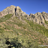
Iron Dike. It's not small. It is steep.


I figured out where I could park and most of the route I would take to the top of Iron Dike, but it was more than I wanted to take on at the time. I'm glad I didn't climb it then because later I saw that I could take a road 3/4 of the way up.


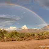
This is not a good thing to see as you head into the wilderness.


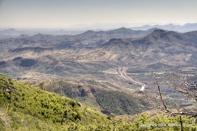
It's difficult to see the smoke from the fire in a regular picture.


An HDRI brings out the smoke.


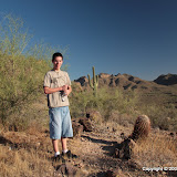
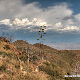
I eventually got to a spot where it looked like I could climb a "small hill" and have a view of the Tonto Basin. I know from experience, though, that 95% of the time that you get to the top of a hill, there is another hill up there. I decided to climb it, anyway, to see if I was really sick. I even played a little "legs vs. lungs". (It was at 6000 feet, so it was a tie.) I felt fine. It was good to know I wasn't sick or about to have a heart attack or something.


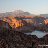
Most of the area up there was burned in a wildfire a few years ago. I don't remember the name of it. Richard and I drove up to Payson at night while it was burning and it looked like there were flames everywhere. There was plenty of evidence of the fire up there. There were also a lot of tiny new plants growing.


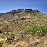
It was only about 95 up there, but there was only a light breeze blowing. It was very quiet. I haven't been out in the wilderness much lately, and it was nice to get away from everything for a little while. Click below to see all of the pictures.


2009_08_30

Sunday, August 23, 2009

Stormy day

There was a pretty good chance of rain on Saturday, so I was going outside now and then to check on the clouds. I took Suzanne's car to fill it up and didn't see much on the way, but when I was just about home I noticed heavy rain falling over by the Superstitions. I grabbed the camera and headed over to Apache Trail. I went to see flooded washes and maybe some lightening (I could hear thunder), but I didn't really expect to see anything worth taking pictures of. I like to watch rain, but it usually doesn't make very interesting pictures.


I drove through some pretty heavy rain. It washed the crud from the car wash off of my truck (long story). Didn't see any flooded washes, though. Maybe the ground was too dry and soaked it all up. The storm seemed to be moving pretty fast, too. As I was headed back to the house, I saw a beautiful rainbow.


It was still sprinkling and I didn't want to get my fancy camera wet, so there are doorposts and mirrors and a fence in some of the pictures. I just pulled over to the side of the road to get a few pictures. About 5 other cars pulled over in the same area.


2009_08_22

Friday, August 21, 2009

First Water Overlook

On Wednesday, Erik and I headed for the First Water Overlook trail near Canyon Lake. Erik wonders why it's called First Water Creek when there is obviously no water in it. Good question, but I don't name these things. Well, I only name a few of them.


As usual, the view was fantastic.


Erik is a very adventuresome person, always looking for new things to try, always looking for new experiences. He's one of those people that when he's old and gray, he won't be saying, "I wish I'd done such-and-such". On this hike he did something that I haven't done in six years of hiking in Arizona.


I usually see a lot of these ants while hiking. Horned lizards eat them.


On my hikes, I usually come across large red or black ants. A lot of people here call them fire ants, but they are not fire ants. I've had numerous encounters with fire ants. These large ants are very gentle compared to fire ants. In 6 years of hiking past them and probably over them, I have never been bitten. On his second hike in Arizona, Erik stopped to get some pictures of a particularly busy ant nest. (I started to call it a mound, but they don't make a mound. They carry the dirt they excavate away so there is no mound.) He didn't seem to notice that he had stopped in a heavily traveled ant path (these ants leave visible trails along their heavily traveled routes). Soon his pants legs had about 20 ants each. He tried to shake them off and we went on our way. I asked him to let me know if they bit because I've never been bitten by one, to which he replied, "Ouch!". Before they were done they had bitten him 4 or 5 times (fire ants with as much time as these had would have bitten him about 30 times). He said they were quite painful for a while.


While trying to figure out what kind of ants they are, I found out that Arizona has 318 species of ants, which is more than any other state. I haven't found a web site that's good for novices to look up ants, though.


That evening we went scorpion hunting. We had been looking for about 10 minutes and I was about to give up and go look someplace else when I spotted the biggest scorpion I have ever seen in Arizona. I should have put something next to it for scale when I took pictures, but I didn't think of that. Also, I didn't have a tripod with me so I didn't get very good pictures. Erik had been saying he wanted to catch a scorpion, but after his encounter with the ants he didn't seem anxious to tangle with a scorpion.


A large scorpion. Erik took a flash picture while my shutter was open, which produced an unusual effect.


2009_08_19

Tuesday, August 18, 2009

Erik takes a hike

Lauren has a couple of friends visiting from Wisconsin. They say that a hot day there is about 80 degrees. Still, Erik wanted to go for a hike in the desert. I didn't want to go someplace that would be to rough for somebody that wasn't used to the heat. On the other hand, I didn't want to insult Erik by going someplace that was too easy. I decided that we would hike to the top of a ridge in Bulldog Canyon. We would take a route that would keep us in shade most of the way.


I always wear long pants (denim) when I hike. I like the protection. I see people hiking in shorts and figure I must be clumsy to have to wear long pants. Erik was wearing shorts, but I didn't say anything. I probably should have since we would be hiking off-trail. I don't think he had any long pants with him, though, so it probably wouldn't have made any difference. Erik's tough, though.


Erik wouldn't stay out of the cholla balls.


He doesn't look like he's melting in the sun.


We got to the top of the ridge and cooled off in the shade of a saguaro before starting back down. On the way back, I took a slightly wrong turn. Then Erik started saying that we had come up some other way. He said he could see a way down in a direction that I didn't think there was a way down. We had enough sunlight, energy, and water so I followed him. It wasn't too long before we got to one of the tallest cliffs on that ridge. No way down. Erik was saying that he thought he could get down the cliff (teenagers are invincible, after all), but I'd had enough nonsense and didn't want to have to tell his family how he died. We went back to the top and down my way.


Erik didn't have much of a problem with the heat. He had some long pants with him to go for another hike today. I have a few things I need to do around the house today, though.


BC_2009_08_17

Sunday, August 16, 2009

Forest Road 1705

I went up near Bushnell tanks again. As you go north on the Beeline Highway(87), you can see the outside temperature slowly dropping. Just south of Bushnell tanks, the north and southbound sides of 87 change places and take slightly different routes. As you head north, you will see the southbound traffic to your right. It's a little strange the first time you see it. A short distance after they switch back to the normal sides, the road crests at a pass. That's where the temperature really drops. It's very noticeable if you are on a motorcycle.


It was about 105 as I drove out of the valley yesterday afternoon. I was headed for a road I had seen on Google Earth a couple of days ago. The road intersects 87 just north of that crest. I had never noticed it before, maybe because I was always looking up ahead at the Bushnell tanks exit by then. It looked like it might take me close to Black Mesa, and Black Mesa might be something cool to hike to the top of. Anyway, when I turned off of 87, the temperature was only 94.


The road (Forest Road 1705) was in good condition, but it looked like it wasn't used much. There had only been a couple of vehicles out there since the last rain, which was probably a week ago. I don't think the official road goes by Black Mesa. I wound up parking by a mountain north of Black Mesa and wandering around there for a while.


There was a roadrunner in the middle of the road. It was hiding in the grass by the time I got the camera out, though.


Not many clouds around.


Black Mesa


Where I went hiking.


I didn't feel energetic enough to go all the way to the top of the mountain I was climbing. I only saw one unusual thing out there. On the way downhill, I saw what looked like small sinkholes. There was no dirt piled around them, as if they were animal holes that had collapsed, or holes dug by people. They made me wonder if there was a cave under there, and the dirt was falling through a hole into the cave. I can't think of anything else yet that could have caused those holes.


A sinkhole?


A larger sinkhole.


Click below to see all of the pictures.


2009_08_15

Friday, August 14, 2009

Scorpions

A year or two ago, I had gone out at night with my ultraviolet cap and gotten a few pictures of scorpions. They were all blurred, though, because I didn't have a tripod with me. I finally went again tonight, but a lot of the pictures are blurred again because I didn't have the lens on the camera that I should have had. So many excuses. Anyway, here's a few pictures.


I found 3 scorpions, but this is the only one that waited around while I got the camera set up.


I think it was chasing bugs when it moved around, because it moved really fast.


Instead of enhancing details, Photomatix decreased them in this case. Well, it is a really strange picture. Maybe if I played around with some parameters, in my spare time.


2009_08_14

Tuesday, August 11, 2009

Service manual illustrator?

This past weekend, Kyle and I put some handlebar risers on my bike. Since it involved taking some stuff apart, I decided I had better take some pictures so I would be able to put it back together. I like the way some of the pictures turned out, except I wish I had dusted the bike off before taking them.


This picture shows where the front brake line that comes down from the handlebar gets split to go to the two front disk brakes.


I got to wondering, "Could I make money taking pictures as illustrations for service manuals?" So I looked at some service manuals. The first thing I noticed is that my pictures would have to be black and white. I can do that.


Converting to B&W is easy enough.


Even in B&W, though, my picture didn't match the quality of those in the typical manual. So next I tried reducing the contrast and compensating for that by making the picture too bright.


A little less contrast, a little more brightness.


That still didn't do enough, though, so I threw in a little graininess.


The graininess is subtle, but it has a noticeable effect on the amount of eye strain felt when trying to pick out details in the photo.


I had come a long way, but it seemed that I still had a long way to go. I wracked my brain trying to figure out what I was missing. Then, in a forehead smacking moment of insight, I realized what I was doing wrong. My picture was much too big. So I tried scaling it down to a better size, then threw in another dose of graininess (you can never have too much graininess in a service manual illustration), and voila.


Now we're talkin'!


I think I'm ready.


Concours_2009_08_08


P.S. This post is not intended to poke fun at Kawasaki service manuals. I don't think I've ever even seen a Kawasaki service manual. It's just about service manuals in general, which seem to be designed to frustrate rather than assist.

Monday, August 10, 2009

Little Mt Ord

For years, I've driven by Mt Ord and looked at the dirt road winding up its side and said, "Some day I'm going to drive up there." I started up once, but there was a sign saying that the road was one lane and it seemed pretty steep at the beginning. I didn't want to get to a point where I couldn't go up and I couldn't turn around and there were irate people behind me. I figured I would drive my ATV up there, but that just never happened. Anyway, I decided that Sunday was going to be the day. It's usually 5 to 10 degrees cooler up there than it is down in the valley, so I was going to drive as far as I could and hike further if I had to.


The view at my first stop.


It turns out that the slope is pretty gentle, and the road is in pretty good condition. It is one lane, but wider than most of the roads in Bulldog Canyon. I stopped at the first pullout I came to so I could take a look around. It was already below 100 outside. I followed a pipe I found at the side of the road and it led me to a water trough. There was barely enough water for the bees and wasps, though. It looked like I was already far above the Beeline Highway, but the amount of noise from the sparse traffic was surprisingly loud.


The Beeline Highway snakes south.


The road ahead of me.


I saw three other vehicles on their way up in the first quarter of a mile. It seemed really crowded. I continued up and came to an old stock pen in a grove on pines and alligator junipers. A side road went off to the right. I decided to try it. Now that road is truly one lane. I'm going to have to wax the sides of my truck again to get the scratches from branches out. There was a rock wall on my left and a near vertical drop on my right. The road was very rough. Every one or two tenths of a mile it got wide enough that two vehicles might be able to squeeze past each other. I dreaded meeting somebody coming the other way and having to back up a tenth of a mile on that road. I dreaded having to go around somebody on the cliff side, and wondered if the pines would stop my tumbling. Oh, the things I do for fun. I must be nuts. I wish I had gotten a picture of that road. At one point there was a boulder that had landed about 2 feet into the rock wall side of the road. I inched around it very slowly and carefully. When I came to it on the way back, I tried to move it out of the way. I got it about 4 inches back, which made me feel much better as I went around.


I continued along that road until I got to a wide loop at the only flat spot for miles. I parked there and got out to discover a great view to the south.


Looking south. Yep, that's the Fountain Hills fountain.


I was still a few hundred feet below the summit. There was a good strong breeze and the temperature was only 84. Unbelievable. To the northwest of my parking spot was Little Mt Ord. It looked like a nice short stroll from where I was, and it turns out it was a climb of only about 133 feet. I was at about 6000 feet, so I didn't need to do a lot of climbing.


Red Mountain in the distance and the Beeline Highway far below. Those buildings are the topless joint at Sunflower.


An alligator juniper doing a scene from "Alien".


The Mogollon Rim is still far away, and that fire is still burning.


I took lots of pictures of sticks, but this is about the only one I like.


The sun was still high in the sky, but I didn't wear my hat. I wore it on my hike last weekend and I had a migraine aura (I just get the auras, not the headaches, which is fortunate). As I walked along thinking about it, I realized that I started getting them a lot at work about the time that I started wearing a cap at my desk to keep an overhead light from shining in my eyes. About the time the RIF was over was also about the time that light burned out, and it hasn't been fixed so I don't wear my hat. I think wearing hats is probably what has been causing most of the auras I've had recently. Well, since I can't wear a hat, I guess I'll have to start working on a comb-over. HA!


It was a little strange on that peak. I kept going over to the north side to get pictures of stuff in that direction and then coming back without any pictures. Hmm, low oxygen at 6000 feet. I guess I kept thinking I would eventually find a spot with a view to the north. Anyone that has spent much time in an arid climate knows that the north side of hills and mountains can be covered with trees while the south sides are bare. The south sides get dried out by the constant sunshine but the north sides retain enough moisture for the trees. I couldn't get pictures to the north because of all the trees.


I never encountered any other vehicles on that narrow side road. Thank goodness. When I got back to the main road, I almost continued on up that road. It was late, though, so I decided to save that adventure for another day. In fact, I've got at least two more trips planned in that area. I may make it through the summer without heatstroke after all.


Click below to see all of the pictures. That reminds me about something I've noticed. Recently, Google added the number of times pictures have been viewed to each picture in Google web albums. I have noticed that the pictures I sprinkle through my blog get a lot more views than other pictures in the web album. I don't always put the best pictures in the blog, though. Some people are missing out.


Mt_Ord_2009_08_09

Thursday, August 06, 2009

Proposed mine, editorial

The Arizona Republic has been running editorials regarding the mine that will wipe out the area in which I've been hiking lately (east of Superior). Click here to see the latest.

Sunday, August 02, 2009

Escape to Four Peaks

Every winter, I think about going up to the trails near the top of Four Peaks, but it's too cold up there then. I tell myself that I should go up there in the summer when it's too hot to hike down here. But for some reason I have always forgotten to go up there in the summer. I think the reason is that by the time it gets too hot to hike down here, the monsoon rains have started, and Four Peaks seems to be a thunderstorm magnet. Not a good place to be when there is lightening flashing. Last Friday, though, I decided to head up there, and there weren't any threatening clouds around when I left the house early Saturday afternoon.


It seemed strange to be leaving the house so early. I guess that's because I'm not used to going so far. I kept thinking that the sun was too high and I'd get burned to a crisp, and the lighting was bad for pictures. I had to keep reminding myself that it would be cooler and later by the time I got up there.


The beginning of the road to Four Peaks. It was about 110 degrees here.


This is from a few miles closer. Down to about 107.


Done to 104 here. You can see the road ahead of me. If you zoom in you can see the road going to the left far off in the distance.


Looking back towards where I took that last picture. Down to 103.


The road was pretty much deserted on the way out there. One Lexus SUV in a hurry passed me on the way out there. One truck went by in the other direction. Two ATVs went by in the opposite direction. The first one was taking his time, enjoying the ride. The second one must have been in a race. He came flying around a corner and almost hit my truck. I scared the dookie out of him. I don't know how people are able to drive out there as if they are the only vehicle on the road. I couldn't do that. Maybe that's because I'm so old. Or maybe that's why I'm so old. And maybe the way they drive explains why I see so many medical helicopters going out there, and why there are little crosses beside the road sometimes.


I just remembered that I saw another group of about 4 ATVs parked in the shade of cottonwoods at a dry wash. These were the kind of ATVs with bench seats that hold about 4 people. The people sitting in them looked like they were trying to get a break from the heat. I quickly adjusted an air conditioner vent so that it blew my hair. The young lady sitting in the ATV closest to the road was wearing sunglasses and her skin was flushed red in the heat. I watched her out of the corner of my eye as I drove by. Her mouth was open slightly as she watched my hair blow in the cool breeze. Her mouth opened wider as I popped a Pringle in my mouth. I'm such a jerk. It looked like they were on their way down hill, descending into Hades. I wondered how many of those girls would be breaking up with their boyfriends at the end of their trip.


By the time I got to the trailhead, the temperature was down to 94. It felt downright comfortable. Since the sun was still pretty high, and because I was above 6000 feet, I wore my hat. I don't think I needed it, though. I was in the shade of trees or on the shady side of a mountain most of the way. The steepest part of the trail is at the beginning, and that isn't bad. The trail is not very rocky, either. It was easy to follow, even though it was overgrown in some places.


Mmm, the scent of pine, and a cool (relatively speaking) mountain breeze, and the sound of wind whistling through pine needles.


A shady trail.


A lot of these were leaning over the trail. They have thorns. I didn't take them very seriously, though.


A scratch from those thorns that I didn't take seriously.


The trail seems to wind back and forth on either side of a ridge line. At times there were views of Roosevelt lake, but there didn't seem to be a lot to see in the other direction. There are many dead trees in the area. A lot of them were killed by a wild fire in the '90's. More have been killed recently by pine bark beetles.


I got hungry after a while and sat down to eat some food bars. I was in the shade, looking out over Roosevelt lake, and not sweating. I was thinking about the Four Peaks Wilderness area, and how I had read that it has the highest density of black bears in the U.S. It would be cool to see a bear. My sister and I had seen a bear cub in Big Bend once. We were probably lucky we didn't get mauled. About that time I heard a crunch behind me. I'm sure you would have laughed if you could have seen me jump. It turned out to be a couple of tree branches bumping each other in the breeze. It sure got my heart rate up, though.


Roosevelt Lake.


I checked the time once and was dismayed to see how close it was getting to sunset. I decided that I would continue on the trail until 6. After a while, I was sure that 6 had come and gone, but it seemed like I was almost to someplace important. I kept telling myself, "Just a little bit further." I'm glad I kept going. I didn't get to the end of the trail, but I got to a spot on a ridge with great views to the east and west. I sat for a while on the west side, where a strong breeze was coming up the mountain, looking at all the other mountains I recognized out there. I was looking down at all of them. I was looking down at the Superstitions. They looked tiny, far off in the distance. I could see Saguaro Lake. Stewart Mountain was a tiny little bump, as was Red Mountain. I knew there was a large metropolitan area out there, but I couldn't see it through the haze. I did find downtown Phoenix in some pictures the next day. I took a whole lot of pictures up there, and processed them in various ways (I spent most of Sunday working on the pictures). Some show lots of detail but look unrealistic. Some look realistic and boring because of the haze. None of them are good pictures, especially the ones near the limits of the zoom, but I just wanted to capture what I could see. I put a lot of them on the web album, so be prepared to be bored if you look through them. I'll probably go through some of them later and annotate them with mountain names, etc.


The Superstition Mountains.


Saguaro Lake.


Do you recognize Red Mountain?


I was so happy about having made it to that great viewpoint, I was practically skipping on the way back. I wasn't worried about having to find my way back in the dark (if it took me that long), until I remembered the bears. It was downhill and was too dark for pictures before long. I walked as fast as I could. After a month in the recliner, my legs got really tired. As I approached the parking area I could hear some kids playing. I had to slow down, maybe even rest my legs a little. It would be embarrassing for my wobbly legs to collapse under me as I descending into the parking area.


I got a bottle of water out of the truck to wash the blood off my arm (I wanted to use an old bottle I kept there for emergencies rather than one of the fresh bottles in my pack). The water was still hot from my truck being parked in the driveway in the valley hours ago. As I got to the main road down, I could see lights coming on down in the city. I thought about staying to get some pictures, but it was already going to be well past my bed time by the time I got home. Besides, I think the lights were probably too far away to get a decent picture.


The drive back was long and uneventful. I checked the thermometer shortly after starting down and the temperature was 74. I turned off the A/C and rolled down the windows. After a while, me ears got cold! The temperature climbed as quickly as I descended, though. I saw four kangaroo rats and a tarantula along the way.


Click below to see all of the pictures. There are a lot and they aren't very good, but you might see something that interests you.


Four_Peaks_2009_08_01