Sunday, May 31, 2009

Back to the desert

After several days in sultry south Texas, it was good to be back in the desert. I had fun in Texas, but I don't miss the humidity.


I thought I should go on an easy hike since I've been a couch potato for over a week, but I would up going to the top of a group of small mountains between the Salt River and Stewart Mountain. I've been wanting to see what was on the "other side" for a while.


I saw a lot of fish hook pincushion cacti with flowers on this hike. I seem to remember that in past years they only had flowers for about a week, so I didn't have much of a chance to get pictures of them. I've been seeing flowers on them for several weeks this year, though. Most of them that I saw on this hike had closed up for the evening, though.


From 2009_05_30


The view of the other side is not unusual or even interesting, but who would know if I hadn't gone to look? I saw some other things I want to check out while I was up there. Who knows, I might find something interesting up there yet.


From 2009_05_30

On the other side of the ridge... another ridge.


I took pictures of areas in Bulldog Canyon in which I frequently hike. Even with the shadows of the late afternoon sun, it doesn't look nearly as rough as it does when you are walking across it.


From 2009_05_30

Deep washes and tall mesas look like nothing from up here.


From 2009_05_30

I've spent a lot of time wandering around out there.


From 2009_05_30

A group of four buzzards came by to check me out. I must have been moving too much. They circled a few times and left.


From 2009_05_30

I spent a lot of time over there this spring.


From 2009_05_30

There were a lot of holes like this. Something digs a quick hole, goes inside and the shoves a bunch of dirt up to block the entrance.


A map and all the pictures are below.


Another ridge at EveryTrail

Map created by EveryTrail:GPS Geotagging


2009_05_30

Thursday, May 28, 2009

NOT the desert

Peggy, Anthony, and I went for a stroll around a couple of small lakes at Brazos Bend State parks, which is about the opposite of a desert (as you will see in the pictures). We walked 4.5 miles and my feet were tired but the only time I breathed hard was to catch up with the other two (I kept stopping to take pictures and they kept walking because a storm was on the way). We didn't get back to the car before it rained, but we didn't get too wet, either. Here's the map and the pictures.


Brazos Bend State Park at EveryTrail

Map created by EveryTrail:GPS Geotagging


I exported the GPS data from the a-trip software after I had geotagged the pictures. As a consequence, the Everytrail map has waypoints on it for every picture (but doesn't have the pictures). Kind of clutters up the map. Live and learn.


Wharton_2009_5_24

Thursday, May 21, 2009

Chihuly at the Desert Botanical Garden

During lunch today some co-workers and I went to the Desert Botanical Garden in Phoenix. There is an exhibition of glass sculptures there by an artist named Chihuly. It was overcast (it even sprinkled a little). I think I would have rather had bright sunshine and blue skies for a background, even at noon. I didn't get any great pictures, but they show some of the artwork (and cacti and lizards and other critters). Click below to see the pictures.


Desert Botanical Garden 2009_05_21

Tuesday, May 19, 2009

Rocks and clouds

We had some interesting weather today. There were storms here and there. After work, I kept seeing great clouds that I wanted to get pictures of, but I had a lot of other things that needed to be done. I finally got out to Bulldog Canyon just before sunset. I wandered around for about an hour taking pictures of rocks and clouds and enjoying the quiet.


BC_2009_05_19

Sunday, May 17, 2009

Cross Canyon hike map

I'm so lazy. Just got around to making this map.


Cross Canyon hike at EveryTrail

Map created by EveryTrail:GPS Geotagging


I wonder if my speed really jumped up to about 5 mph on the way up. It could have at a level spot in the road. There were a couple of those.


I'm very suspicious of the 2000 feet up and down. The data says my minimum and maximum elevations covered 1000 feet. As I noted earlier, this hike did not have much PUDs. I doubt that I covered much more than 1000 feet. Maybe 1100. The other 900 feet must be meandering GPS altitude error.

Cross Canyon

Yesterday I wanted to go someplace I'd never been before. I was looking around Superior in Google Earth and noticed some dirt roads heading off into the wilderness. I decided to drive on some of them and if I couldn't drive, I would walk.


On Google Earth, it looked like I could drive east out of town on the old road between Superior and Globe. I turns out that you can't get to the old road, though. While I was driving through town, though, I came across the old high school. It's the second oldest school in Arizona (the oldest is in Globe). It's closed now because of asbestos. It has for sale signs on it, but I hear that some guy bought it for $250,000.


This doesn't look like a place I would want to spend 3 or 4 years as a teenager.


I headed south on 177 and turned off at the first dirt road I'd seen in Google Earth. The tires slipped and spun on the steep, gravely road for about 30 feet before I got to a place to park, and park I did.


I parked near the cross on the east side of town.


An advantage to going to Superior is that it's at a higher elevation, which makes it slightly cooler than the valley. I think it was about 95 when I got out of the truck. I followed the road to its end, so the walking was pretty easy. By easy, I mean it wasn't real steep, not any PUDS (Pointless Ups and Downs; thanks anonymous), no grass to hide rattlers, no cholla to stab my legs, etc. It was very rocky in places so it was a good ankle workout. My new boots tend to slide a little easier than most I've had in the past. On the way down I got used to sliding a few inches every now and then.


On the way up, I almost stepped on a lizard before it ran off. That's unusual. It happened again on the way down and I almost pulled a muscle dancing around trying not to hurt the lizard. I also came across a snake. I saw one just like it last Tuesday but it got under a brittlebush before I got a picture. This one stayed in the road while I took pictures. It's a western patch-nosed snake.


It's a little noisy at the end of the road, where you can hear the traffic on 60.


US 60 far below.


I wonder if I can get up there.


On the way up the road, I saw several spots that looked like mine tailings. I checked a couple of them out, though and decided that it was dirt that had been pushed out of the way while making temporary roads, maybe while fighting a fire many many years ago. Then on the way down I glanced to my right and saw a mine entrance that had been closed off with a grate. It wasn't until I got home and was looking at pictures that I could see that some of the other piles of dirt were mine tailings. In the pictures I could see grates covering abandoned mine entrances.


Click below to see all of the pictures.


2009_05_16

Tuesday, May 12, 2009

A less gnatty hike

The past two hikes I've been on were really frustrating because of all the gnats. I didn't really want to go for a hike today because of the gnats. They are almost as bad as they were the summer of 2005 (or maybe it was 2004). That was a super bad year. I even tried carrying an electric fly swatter on hikes with me, but the gnats were so small they went through the holes in the mesh without getting zapped. Anyway, I decided I'd go for a short hike to see how bad the gnats were in a place I haven't been recently. I've always thought it would be cool to be on top of the cliffs by Saguaro Lake, so I thought I'd try that today.


Saguaro Lake Cliff at EveryTrail

Map created by EveryTrail:GPS Geotagging
The route I took. Only 250 feet between lowest and highest points, but I climbed 1000 feet.


I parked on the side of Butcher Jones road. That means that I had to be out of there by sundown. There were a lot of small ridges and washes between me and my destination, but I wasn't worried about that; it was going to be a short hike.


There's always something unexpected. I saw a lot of paintballs out here.


Nice shade, but it was below 100 and the sun was low; very comfortable compared to Saturday.


I ran across a saguaro that had a beehive in it. I've never seen that before. I didn't get any good pictures of it because I've gotten a little paranoid about stirring up killer bees. It would have been very difficult to run back to my truck from where I was.


It didn't take very long to get to the cliff. Oh, and the gnats were there but not very pesky. The view was nice up there and there was a great breeze coming up the cliff. I watched the sun sink behind Stewart Mountain and then hurried back to the truck to get out before sunset.


The view of the lake.


A red tailed hawk checking me out.


I saw a lot of things that I wanted to take pictures of on the way back to the truck, but the sun being behind a mountain made me think that it was later than it really was. I think I got back to the house before sunset. Click below to see all of the pictures.


2009_05_12

Sunday, May 10, 2009

Another map

I made an EveryTrail map of my recent hike in Bulldog Canyon. It confirms something I've suspected for a long time. The minimum altitude and maximum altitude say that I only climbed a little over 600 feet. Then why was I so tired? Well, when you look at the EveryTrail map, you can see that I climbed about 1300 feet and descended about 1300 feet. All those little ups and downs crossing washes really add up. That's why I try so hard to avoid them. And you thought I was just lazy.


Bulldog Canyon stroll at EveryTrail

Map created by EveryTrail:GPS Geotagging

Another experiment

I was looking at Google Earth again and saw these EveryTrail markers that seem to be similar to the @trip trip reports. I looked at a couple of the EveryTrail trips and I couldn't tell if people just didn't add any text to their pictures or if EveryTrail lacks that capability. Anyway, I was thinking about how I sometimes want to show a map of where I went without putting pictures on the map and if I want to do that with @trip I have to remember to upload the track before I geotag the pictures (or they get added to the track). It looks like I could use this EveryTrail page to create maps that show where I went, with no other info. Here's a sample map of a recent hike along the Salt River.


Hike along the Salt River at EveryTrail

Map created by EveryTrail:GPS Geotagging


One thing I like about the map is it shows the total ascending and descending feet climbed. There seems to be a problem with the data in this map, though. I didn't fall into a 1000 foot deep hole on the bank of the Salt River, but that's what the map makes it look like. That must have been when I was crawling through all those trees and the satellite reception wasn't very good. Got down to 3 or fewer satellites and the elevation data went wacky.

Hot

I picked a random spot near Tortilla Flat to go hiking on Saturday. It was kind of warm, though (103). I stopped where I could park at the side of the road and headed uphill. There were lots of cool looking rocks up there. I didn't get pictures of all of them, though. For some, I kept thinking I would get to a spot where I could get a better picture, but I never did. For others, I forgot to check until I was past where I wanted to be.


A large, precariously balanced boulder.


A couple of buzzards swooped low to check me out.


I went early because I'm tired of having to cut hikes short because the sun is setting. I think I went too early, though. There was a decent breeze and it dried me out, but it didn't cool me off. The gnats were really bad, too, despite the breeze. Unfortunately, all the shady spots also had the wind blocked. When I skipped taking some pictures because the gnats were so pesky, I knew it was time to leave.


The shadow of this saguaro was the only place with shade and a breeze.


Crossed eyes stereo picture of a rock spire.


Click below to see all of the pictures.


2009_05_09

Saturday, May 09, 2009

Map of Thursday's hike

I made an @trip map of Thursday's hike. If you download a plugin, you can view a 3D map of the hike on the @trip page. Sometimes that gives an interesting perspective, but sometimes it just looks strange.


Friday, May 08, 2009

A ridge I haven't climbed for a while

I've been feeling kind of puny all week. I had a sore throat Wednesday evening and felt drained of energy. I was seriously considering calling in sick on Thursday. If I was coming down with the virus formerly knows as swine flu, I didn't want to spread it around at work. I didn't feel any worse Thursday morning, so I went on to work. By late afternoon, I felt like I needed to go for a hike. As I drove out to Bulldog Canyon, though, I kept thinking about how drained I felt and that I should probably be at home resting, saving my energy to fight whatever was attacking. I decided to get out and take a few pictures and see how I felt. There were probably too many gnats to hike, anyway.


There's a ridge in Bulldog Canyon OHV area that I spent several months trying to figure out how I could get on top of. I made several attempts but was stopped when it got too steep or I was blocked by a cliff or the only route I could take would violate one of my hiking-alone rules. Hmm, maybe I should call them "old man rules". I mean, whether you are hiking alone or with a group, you don't want to fall of a cliff. To paraphrase a not-so-old saying, "There's old hikers and there's bold hikers, but there's no old bold hikers". But I digress.


I did finally get to the top of that ridge (using Lindsey's suggestion of starting out at the NW end). It wasn't easy, though. It was steep and there were lots of obstacles and I think it was about 106 that day. On Thursday, though, as I drove toward the ridge, I picked a place to climb. I couldn't see how I would reach my goal once I got on top of the ridge, but I figured I would solve that problem when and if I got to it. As I started towards the ridge I felt strong and tireless. Hah! I wasn't sick. I just needed to get out in the desert.


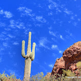
My goal is to be up there where those saguaros are.


The gnats were as bad as I was afraid they would be. I've learned how to swat them without hurting myself, though. Several times, I wiped out about 10 of them with one swat. There was always a sizable cloud of them around me, though. Being this close to the ridge, the breeze was blocked, which is not good during gnat season. Because of the gnats, I didn't want to stop and take many pictures on the way up. These days I take mostly exposure bracketed pictures to create HDR images, which means I have to stand very still for about 3 seconds. Try doing that with gnats crawling in your ears and up your nose.


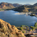
Once on top, I saw a route to the saguaros on the other side of the ridge.


It was surprisingly easy to get to the top of the ridge. I think my new boots (Danner Pronghorns) help a lot. They are extremely light, probably the lightest shoes I own. When I walk on concrete, they feel like soft cushions under my feet, but when I step on pointy rocks, they provide an unyielding barrier that protects my feet. I feel like I can walk over anything. Well, maybe not molten lava, but lots of stuff that gave me problems before. They seem to have a tiny bit less traction than the cheap boots I'm used to wearing. Because of that, I've changed the way I walk down very steep slopes. I kind of go sideways. Less likely to hurt my tailbone if I fall (hope I don't break a wrist, though).


Anyway, I got to the ridge pretty quickly, which is good since the sun was getting low. I wanted to stay up there for a while, but I needed to find my way down while there was still some light.


The saguaros viewed from on top of the ridge.


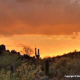
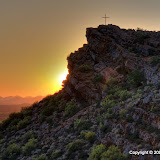
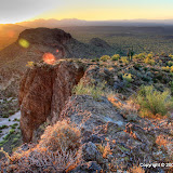
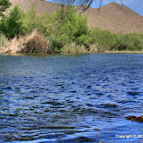
The setting sun makes everything red.


The late afternoon sun really makes everything red in the pictures. I probably need to take those pictures in RAW mode so I can play with the white balance.


Click below to see all of the pictures.


BC_2009_05_07

Sunday, May 03, 2009

Back to the Salt

The weather is warming up. It was around 90 when I went for a hike today. That wouldn't have been so bad if I hadn't started out at 1 in the afternoon. The sun felt hot. Good thing there were some clouds (thin, but anything helps) in front of it now and then. There was also a very nice breeze most of the time.


I decided to work on finding a route to that canyon I want to get to. I thought I might be able to get some pictures of red winged blackbirds, too. Near the beginning of the hike, I saw a red tailed hawk. I think I've seen it in this area before. I got a few pictures of it this time.


It was keeping an eye on me.


I followed a route closer to the river this time. I got to a point where progress was blocked by a forest. The annoying thing about these trees is their branches hang down to chest high or lower, so you have to keep ducking to get through. Speaking of ducks, I heard some noisy ones but didn't get any pictures of them.


Wandering through a forest.


Along the way I found a shady spot with a nice view of the river (the view is usually blocked by bamboo (or maybe it's just reeds) or trees). Somebody had made a bench out of an old tree trunk. There was a cool breeze coming off of the water. Every once in a while, beautiful girls would float by in inner tubes. Actually, it's more like every once in a great while. Four attractive, friendly, and sober girls did float by. Judging by what I saw and heard the rest of the day, they were the only sober people on the river.


I also saw several red winged blackbirds while I was there. They fly by too fast for me to get a picture, but I really want to get them in flight. I got some pictures of one perched across the river, but that's it.


A cool, shady spot.


I came across an entertaining lizard. Most lizards run away when they seen me coming. This one ran back and forth a few times, then ran past me (within a couple of feet), then zipped on down the trail. It was hard to get pictures of him.


Speedy the lizard charging towards me...


... and then charging past me.


I got to the place where I thought I should turn south. It looked like I had a clear shot at the canyon. I couldn't tell that there was a dense stand of trees in the way until I was almost in them. I pushed through and encountered the next obstacle; a wall of rock. That stopped me.


I turned right here.


The only route up this rock wall was blocked by trees and cacti.


I don't like pushing through those trees. I'm paranoid about ticks. Actually, it's Lyme disease that's got me worried. I'd had enough trees for one day, and I still had to get back to the truck. I took the route further away from the river as soon as I could get on it. I looked at Google Earth when I got home and saw the error of my ways. I need to go a little further east before turning south. Maybe next time.


BC_2009_05_03