Monday, October 29, 2012

Return to NFr 213

Well, I just spent about an hour searching for pictures I had taken the first time I was on NFr 213. Couldn't find them. I think it must have been some time around 2005. Maybe 2006. I didn't try to drive on the road at all then; too rough. I had watched some other people drive up the rough part of the road and most of them seemed to be having a lot of trouble. I hung around for a while watching one guy because I was sure he was going to set his tires on fire (he didn't). I don't remember much else from that hike, except that I was very tired by the time I got back to the truck and that I had to make a walking stick along the way so I could make it back.

I've driven up part of that road 3 or 4 times since then. I've always had to stop at the part where the guy tried to set his tires on fire. It's very steep and very rough there. You wouldn't think it was a road if it weren't for the tire marks. I haven't hiked on that road since the first time I was on it, though. Any time I think about it, I remember how tired I was and go someplace else.

The reason I'm yakking about this is, of course, because I finally drove down that road. There were a couple of times when it seemed like the truck was vertical, but the tires never slipped and the truck just kept going. I did manage to get a small ding in the skid plate. I wish I had a movie or some pictures going over the rough part, but I wasn't about to put on the parking brake and get out. There were lots of pictures I wanted to take along the road, too, but I didn't want to spend a lot of time on that road because most of it is only one vehicle wide. The spots where you could get around somebody are barely wide enough to do that.


I got out to look around less than half a mile along the road. I didn't recognize anything.


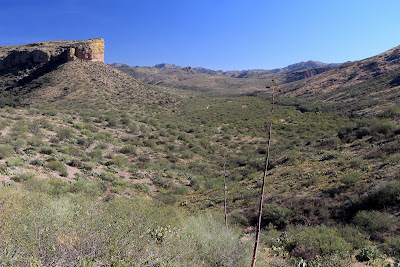
Then I came to these cliffs, which I do remember.

Most of the road is pretty rough, but not scary. Just bumpy. It seemed to be much longer than I remembered. I always used to wonder why I had gotten so tired on such a short hike, but I had walked about 6 miles. That's a long way in rough terrain.


I had turned back shortly beyond the clearing for the ranch down there the first time I was out here. It seemed very far away as I drove toward it this time.


At the ranch house location.

As you get close to the ranch house area, the road is close to an intermittent creek and is lined on both sides with mesquite and cat claw acacia. On my first trip out there I had heard something thundering down the road and wisely stepped off the road into the brush. A suburban roared past in a cloud of dust. I still remember the startled look on the driver's face when he glanced to his right and saw me.

I had to stretch my legs by the time I drove down there, so I headed up a small hill to get a view of the area.


View to the east from the small hill.


Looking back at the ranch from the other side.

I encountered oncoming traffic once in each direction. Fortunately, it was in places where it was easy for us to get around each other. Going back down the rough parts was no less traumatic than going up. Well, maybe a little less, since I wasn't looking at nothing but blue sky on the way down. Click below for all of the pictures.

2012_10_28

Monday, October 15, 2012

203A, and something shiny

Sweetums says that the new truck is much more comfortable than the other one. I was very comfortable in the other one, but this one isn't bad. Anyway, she has actually been going with me when I go wandering off without really knowing where I'll end up. We headed east on Sunday. We wound up going to 203A, which climbs to about 5000 feet and ends at the southern border of the Sierra Ancha Wilderness. I've been up there before and there are beautiful views along 203A. I took pictures of the views the last time I was up there so I didn't take very many this time.


Another saguaro with tires thrown on it.

203A is one lane wide most of the way. It's also a rock wall on one side and an almost vertical drop for about 100 feet on the other side. It's not the kind of road on which you want to encounter any traffic. I encountered another truck for the first time out there while we were on the way down. Fortunately, I was on the rock wall side. I was getting ready to back up to a wide spot about 100 feet back when the kid decided there was plenty of room. I don't know how he stayed on the road, but he did. Nobody in the truck was worried enough to bother with seat belts. Ah, to be young and blissfully ignorant...


This is always a nice view.

Sweetums spotted something else interesting on the way back down. Off in the distance, there was a flashing light. We both wondered if it was somebody in distress and signalling for help. It stopped flashing after a minute or so. I got my mirror out of my backpack (I carry it for those times I need to freshen up along the trail) and was barely able to reflect some light in that direction. We were almost directly between the sun and the location of the flashing light. Anyway, shortly after I did that, the flashing started again. I got out a map and started trying to figure out the location of the light. We had a good cell signal further up the road and I was thinking about going back up there and calling the Pinal County sheriff. I also took pictures an zoomed in on them, but didn't have enough magnification to tell what it was. As I got my bearings and studied the map, though, we also watched the flashing light. Sometimes it seemed to flash too fast to be a person holding a mirror. It was also very regular. It would speed up and slow down and sometimes stop for several seconds. It reminding me a lot of windmills I've watched blowing in the breeze. We eventually decided that was what it had to be.


There's a flashing light out there.


This is the best picture, cropped. On a computer screen, it does look like a windmill.

In the cropped picture, you can see what might be a storage tank to the left. Using roads that were visible in the area and looking for the storage tank, I think I found the location of the windmill. It's at 33 degrees, 43 mintues, 11.67 seconds North and 110 degrees, 46 minutes, 45.60 seconds West if you are interested in looking it up on Google Earth (or any map, I suppose). The coordinates I estimated from the road were a half mile beyond the actual location. That's a high percentage of the 4 miles distance from us, but I think it's pretty good considering that there are no landmarks in the area to help judge how far away it was.

Click below to see all of the pictures.

2012_10_14

Monday, October 08, 2012

To the Miles trailhead

When you leave the Miami / Globe area going east on US 60, you pass some large open-pit mines. There's a road that meanders between the pits to get to some trailheads and a ranch house. The road looks as if it might be there exclusively for the mines. In fact, there are several signs along the first quarter mile or so of the road that say, "Road not maintained for public use". It sounds to me like the mine owners / operators are trying to discourage the public from using the road. They can't just say "Keep Out", though, because it is a public road. As you go a little further along the road, there are signs that direct hikers to the trailheads. When you are leaving, there are signs that direct hikers back to US 60. You wouldn't want to wander off the public road as you go through the mining area. There are monstrously large vehicles in that area with very limited visibility for the drivers. They could flatten your vehicle (and you) without even knowing it. So if you go out there, stay on the road.

Anyway, I went out there to see what I could see. You don't have a good view of the mines from the road. I followed the road north until I got kind of close to the ranch house, then got bored with that direction and turned around. I stopped at a high point in the road to take some pictures.


A 360 panorama taken from a small hilltop.


The ranch house. I actually got a guy walking across the yard. You may not be able to see him in this version of the photo, though.

I then headed west on the road that goes out to the Miles trailhead. It's dirt, of course, but it was in very good condition. It was also a very nice drive through pine and juniper forest. It looked so unlike the desert that I expected to be cold every time I opened the truck door. It was 82 out there, though.


Along the road to the Miles trailhead.

There's plenty of space to park at the Miles trailhead. There are also some other trails along the road, but one of them barely had enough space to get one vehicle of the road and another had room for 2 or 3 vehicles a short hike from the trailhead. I've come across several trailheads in Arizona that don't have anyplace to park a vehicle. I guess the forest service expects those trails to be used only by one-way hikers (they will be dropped off or picked up at the trailhead, but won't need to park there). That seems kind of restrictive. Doesn't accommodate hikers like me at all.

I'm going to have to try out some of those trails sometime, though. It's so relaxing to listen to wind blowing through pine needles. Click below to see all of the pictures.

2012_10_07

Sunday, October 07, 2012

Hewitt Canyon Road, and a couple of changes

The last time I drove my truck up to the Roger's Trough trailhead, I barely made it. There were parts of the road where I just didn't have enough traction. I was moving at a snail's pace and in the places that I had to lock the axle, the rear end kept sliding towards the cliff at the edge of the road. It was frustrating. I've had several similar experiences lately, in which I was concerned that I might be stranded in the middle of the desert for hours. Because of that and a couple of other reasons I decided it was time to get a 4 wheel drive truck.


Four wheel drive Tacoma.

The new truck easily climbed the road to the trailhead. I drove up in 4H. I put it in 4L and downshifted to 3, 2, or L for much of the descent. The truck has lots of buttons and switches that I haven't tried out yet. One that I did try yesterday is the downhill assist control (DAC). It's great for steep, rocky downhill sections where you might have a very jerky ride otherwise because the bumps make your foot press the brakes too hard. It makes a lot of noise but the owner's manual says it supposed to do that.


Video of the DAC in action.

I made 3 versions of that video. You're seeing the least annoying. The others demonstrate a feature of my new camera but I'll just have to talk about it. I got a Canon T4i. I got it for a couple of reasons. I've taken over 40,000 pictures with the T1i, so it might be close to wearing out, and it's always bugged me that the camera wouldn't re-focus while shooting a video. Well, it will, but it takes a long time and looks really bad. The T4i stays in focus while shooting a video. I got the kit that comes with the 18-135mm zoom lens. That's less zoom range that the lens I used with the T1i, but so far I like the pictures with the 18-135 better. That may have something to do with the much higher quality polarizing filter I put on it, too. It's easier to shoot bracketed photos for HDRIs with the T4i (and at least 2 seconds faster). It has some other cool features that I haven't experimented with yet.

My 2004 Tacoma had one small annoyance. The view of the clock was blocked by the windshield wiper switch. The new Tacoma has what might be a slightly more annoying drawback. The front mudflaps are too long. They dragged on the road / rocks several times yesterday, and Hewitt Canyon Road is not what I would call rough. I'm afraid I'll rip the mudflaps off the first time I have to back up on a rough road.

Click below for all of the pictures. There aren't many. I put a panorama I shot on my Panoramio page (link to the right).

2012_10_06