Hiking in the Sonoran desert, with photographs of saguaros, lizards, birds, scorpions, flowers, other desert flora and fauna, mountains, rocks, sunsets, etc.
I'm not sure what the official name is, but Parker Creek flows through it and people call it Parker Canyon, so I guess I will, too. I was near there about 6 years ago and vaguely remembered some nice scenery. I also remembered traveling for many miles on a dirt road with severe washboard. A lot of people that drive on roads like that go as fast as they think they can (which is actually faster than they safely can, which I believe is one of the reason so many vehicles go off cliffs in Arizona) because it makes the washboard less annoying. Mythbusters proved that actually works. Anyway, I'm getting sidetracked. I was looking at the area east of Roosevelt lake (long story, let's not get sidetracked again) and saw a few pictures of a scenic canyon. I decided that I needed to go check it out.
A canyon before Parker Canyon. It was a little hazy.
When I turned onto 288, I was surprised to see that it was paved. I didn't expect the pavement to last long and sure enough, after a couple of miles I saw a sign saying that the pavement would end in 500 feet. But it didn't. It was paved all the way to the turn off for Parker Canyon (NF488).
NF488 goes along the right side of Parker Canyon.
It turns out that it's difficult to see into most of Parker Canyon. At some places along the rim I was sure I could hear a waterfall below, but I couldn't get to a place where I could see it. Part of the reason was the way the canyon twists and turns but probably the main reason was because the closest I could make myself get to the edge was about 8 feet.
Notice how the canyon walls are pretty much vertical. Knowing that the walls on my side were probably the same, I just couldn't make myself walk right up to the edge.
Maybe I should have sat down and scooted up to the edge. Or maybe not. I kept thinking that the rock on the edge looked like it was about to break away. Heights only seem to bother me when I'm standing on a cliff somewhere. Anyway, I walked a long way trying to find a view into the canyon. I think the best view might be from inside the canyon, though. I talked to a couple that were walking back to their car after hiking down the canyon. They said that there are waterfalls in the canyon. They also said that there are 7 rappels from the top of the canyon to where they came out.
I found a few places with a nice view.
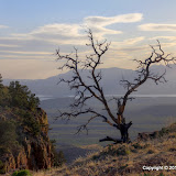
There were other places I wanted to see, but I spent much more time than I had planned at Parker Canyon. The sun was about to set by the time I started to leave, which made for some pictures that I like.
That's Four Peaks on the horizon and Roosevelt Lake in the middle.
I made a short video since pictures don't do a very good job, but the video doesn't either. Turn your volume down; the wind is really noisy.
I think I'll be exploring more out there this summer when it gets too hot to hike in the valley. Click below to see all of the pictures.
I had gone hiking in White Canyon for the first time about a year ago. There was a lot of water flowing through the canyon and in other areas near there. I made the comment that I would have to return in the summer and see if the water was still flowing. I did try to do that last summer, but the "road" had deteriorated and I couldn't park very close. I had parked about 0.8 mile away when I hiked there, and that extra distance wore me out. I couldn't get closer than about 1.2 miles as the road deteriorated and I'm just too lazy to walk that far, especially when it's hot.
I'm taking a long time to get to the point, and I'm not there yet. Sorry. On Friday evening I was trying to decide where to hike the next day (yes, I do actually plan ahead sometimes). I was looking at Google Earth and saw what looked like a road or trail going up to the top of a ridge. The view might be nice from up there, and I would get to see what was in the canyon on the other side without having to climb over boulders or push through shrubbery. And yes, I would rather walk up a 500 foot high ridge than climb over dozens of waist-high boulders.
I charged my batteries, ate lots of lunch, loaded up on water, and headed out. As I approached White Canyon, I could see the road going up the side of the ridge In one spot there was enough dirt piled on the slope that it looked like there could be an old mine up there. Could be interesting. In the satellite view, the road or trail looked like if faded away by the time it got close to the main road. I drove to where I thought I would need to start climbing and it looked like the first 50 feet or so would be very steep and difficult. I kept driving, looking for an easier spot to start. I think 2011 must be the year for bulldozing dirt roads, though, because this one was in much better shape than it had been the last time I was on it. I decided to keep driving and see how far I could get before I climbed the ridge.
I easily cruised past the large cottonwood where I had gotten a huge boulder stuck in my wheel well before. I could have hiked about a mile on the energy I burned up getting that boulder out from under my truck so I could move again. Oh, and I had to do that while standing in flowing water. The spring was dry now though. When I got to the next obstacle, which used to have black tire marks on it from all the people struggling to get over it, it was barely a bump now. I started thinking that I might be able to hike in White Canyon again. The road was remarkably smooth all the way to the entrance to the wilderness area. I had to park a quarter mile away because the final descent is too steep for me to drive back up, but it's an easy quarter mile to walk.
This part of the road might be too steep for me to drive up, but look how close I am!
So far, on the drive, I had not seen any water in places that I was used to seeing it. I had read somewhere that water was always flowing in White Canyon, but I couldn't find it. Anyway, I started up the canyon at about 2:30 and the temperature was in the mid 90's. I stopped in shade whenever I could find it, but there wasn't much.
I eventually came to a puddle. The water didn't look like anything I wanted to drink, or even get on me. It looked stagnant.
The first puddle.
I don't remember seeing this rock column before. It's hard to see unless the lighting is just right. I'll have to climb up there some time to get a better look.
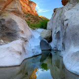
I got to a spot where the canyon floor is solid rock, and there I found flowing water. It emerged from the gravel in a pool upstream and vanished again in a pool on the downstream end. I suppose it looked drinkable as long as you didn't think too much about the people wading in it. It looked very inviting after stumbling over river rocks in the heat. So maybe there is water here year round. It's just hidden part of the time.
A family enjoying the cool water. These are the only people I encountered on this hike.
Not only had the road been bulldozed, but the trail had been marked with cairns. And not only was it marked, but somebody had cut most of the branches out of the way. I was back at the point where I'd had to turn back before in no time. I found an easy path around the boulders that had stopped me back then. I think I may not have been able to get to that path last time because of all the water. Not much further upstream, though, I encountered more truck-sized boulders. I found my way around several of these before I decided that it was getting late enough that I should turn back.
I made a short video of one of the boulder obstacles, from the inside.
Up until I started back, I had taken only 1 or 2 HDRIs. I figured there were so few shadows, I didn't need that. It turns out that there were a couple of places with very bright rocks where I should have used it. I was in the shadow of the western canyon wall on the way back, though, so I wound up taking more HDRIs then.
I like the way this turned out.
I was past most of the interesting scenery and was thinking about how there are bears and bighorn sheep in that area and how I should have been looking around more for the sheep (and probably the bears) when something to my left moved and hissed. I must have startled it for it to jump like it did. It was a Gila Monster, the third one I've seen in 8 years of wandering the desert. I took a bunch of pictures. I think it was too dark right there for video. Anyway, that was the perfect finish to a very enjoyable hike.
Gila Monster sniffing the air.
There's beautiful scenery everywhere you turn out there. Click below to see pictures of a little bit of it.
On Wednesday, not only was I caught up on my chores around the house, but I also got home from work in time to go for a hike. I headed towards Canyon Lake, not too sure where I would go. I picked a place to park and wandered off. When I started out, I was thinking that I was headed up a canyon I hadn't explored before and wondered why I hadn't. Before too long, though, it started to look familiar.
I was sure I had seen this before.
I had been up there about a year ago. I had carefully planned that hike. I went up there because I wanted to get pictures of the view to the east. Once I realized I had been there before, I lost interest in doing a lot of climbing. After all, I was already getting tired.
Ocotillo with flowers.
Instead of continuing to climb, I decided to get some pictures of the flowers. There don't seem to be a lot this year. I've seen hardly any blue lupines or Mexican gold poppies. There are some pretty ones, though.
There are going to be some nice agave flowers soon. I need to get some pictures of those this year.
Ocotillo flowers.
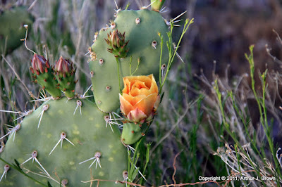
The first prickly pear flower I've seen this year.
Maybe I should hang a map on the wall and draw all of my hikes on it. You'd think I'd be able to use all the pictures I have on Google Earth for that purpose, but the ones I took up there before don't seem to be on Google Earth. Some day when I'm feeling energetic I'll search through my Panoramio pictures to see if I've uploaded any of that area. For now, click below to see the pictures from Wednesday.
I don't know if it's a Forest Road or what. All the sign says is "1900". Can't find a name on maps, or even 1900. It turns off of Hewitt Canyon road. Yes, I went east of town before the Renaissance Festival was over. We got an early start and avoided the renaissance jam.
Roblas Butte, which can also be seen from Hewitt Canyon road.
I was also hoping it would be a little cooler in the morning, and I think it was. I think it got a little too warm for Sweetums, but there was a very nice breeze.
There are lots of pretty rocks and plants out there.
It was nice being on one of the less-traveled roads out there. We saw very little traffic. At one point, I had stopped to get some pictures and Suzanne pointed out that she could hear splashing water. We were next to a wash and there was water flowing in it. The water was coming from Quail Spring and splashing into a small pool.
Water from Quail Spring.
Another hole in a rock.
A lot of the saguaros in this area look like they have baggy skin.
Fishhook pincushion cactus flowers. I usually run across these late in the day when they've closed up.