Hiking in the Sonoran desert, with photographs of saguaros, lizards, birds, scorpions, flowers, other desert flora and fauna, mountains, rocks, sunsets, etc.
Remember the photo point pictures I was taking? Well, anyway, we don't take those pictures in the winter, but the Forest Service has something else to help me explore parts of Arizona that I haven't seen before. It involves getting pictures of creeks. This is a good time of year to do that because there is water in the creeks now. The first creek I visited is the West Fork of Sycamore Creek. It's across the Beeline Highway from Mt. Ord. I tried to go out there about a week ago but there had been a lot of rain and the road was very muddy. If I had driven down to the creek then, I probably would not have driven back up. So I went yesterday. It was a beautiful, sunny day.
Lots of water in the West Fork of Sycamore Creek.
There's a 4WD trail that follows the creek upstream. Most of it is in pretty good shape, except for one washed out spot near the beginning. I didn't want to try to get across that, so I parked and hiked. The road goes uphill for a while, and I got pretty warm going uphill in the sun. I was thinking about stopping to take my undershirt off. Then the road dipped back down to the creek in a narrow and apparently always shady canyon. It was very cool there. I was thinking about getting a flannel shirt out before I got back in the sunshine.
The creek in the shady canyon.
Water moves, so I made a video of it.
Now that I'm looking at the pictures I took, I keep thinking of others that I should have taken. I may have to go back soon. Click below to see all of the pictures.
A few days ago, I was driving out to Canyon Lake and saw something interesting that I had never noticed before. I couldn't get a good look at it because I had to pay attention to the twisty road and I couldn't just stop because there was traffic behind me. Maybe it was just a shadow. Still, I wanted to check it out. I have been meaning to hike out to that area for a few years, anyway. I was just waiting for sufficient motivation.
I want to go in that direction. It's not as easy as it looks, though.
In order to get to where I wanted to go, I would have to cross Willow Creek. I've hiked up and down several stretches of Willow Creek. In a lot of places, it's impossible to get into or out of the creek bed without doing some serious rock climbing. I picked a bad spot to try to cross. There was no way I could get down to the creek. I just wandered around taking pictures for a while.
The scenery is very pretty, but I guess you have to be there. I don't seem to be able to take pictures of it.
It turns out that I've hiked in that area before. I saw some rocks that I recognized. Speaking of rocks, there are a few places out there that have black rocks scattered around on lighter colored rocks. I always thought that maybe people had done that. I looked a little more closely this time, though, and some of those black rocks are on small pedestals left by erosion of the lighter rock around them. Some of those black rocks have been where they are now for probably hundreds of years. That's a little surprising considering all the beer cans I saw out there.
Scattered rocks. Some of these have been right where they are for hundreds of years.
I went back to a part of Bulldog Canyon in which I had hiked about a year ago. Interestingly, in the current (January) issue of Scientific American, Michael Shermer comes to the same conclusion as I did then regarding the computer intelligence singularity, i.e. it will always be a few more years away. I would suspect that he was reading my blog and stealing my ideas if it wasn't such an obvious conclusion. (Plus, I can't imagine contributors to Scientific American doing such things.) Anyway, I thought that was interesting. Now back to the hike.
I took my favorite picture of the outing while I was still driving to the "trailhead".
I've got a couple of weeks off of work and had all sorts of plans for places I was going to go. The time off started last Saturday (the 17th). I got out of bead early that morning, reached down to pick up my phone, and my lower back went *sproing*. I hate it when that happens. It's just as well, though. The next few days were gloomy and wet, so I wouldn't have done much hiking anyway.
This is a scenic walk down a nameless wash (intermittent stream). I'm guessing that I walked about 8 miles. Can't tell for sure because the PN-40 discarded part of my track, and it was a part where I should have had excellent satellite coverage. Well, I could figure it out, but I'm feeling pretty lazy today. I'll never count on this receiver for breadcrumbs, though. It felt like a long walk. My ankles are achy today.
I saw places I want to go explore on my way down the wash. Some day.
The last time I was down there, I took a lot of pictures of puddles. We've had a lot of rain recently, so there were even more puddles. I told myself that I had enough pictures of puddles, though, and I wasn't going to take pictures of any more puddles unless they just happened to be in a good spot and looked good. I wound up with a lot of pictures of puddles again, anyway.
I think I got a picture of this puddle the last time I was out here.
A year ago, I could see some evidence of vehicles having driven down the wash. According to the Forest Service map, they shouldn't be there. I parked at the end of the official road, which is indistinguishable from the non-road that continues to the north. In January, it looked like only a small number of vehicles had gone very far down the wash beyond the end of the road, and there hadn't been any there for at least a couple of weeks. This time, it looked like there had been heavy traffic along most of the wash and there had been multiple vehicles out there the same day I was there (though I didn't see them).
I "hurried" at the beginning of the hike because I wanted to get to the view of the cliff that I like so much while there was still sunshine, and I had gotten a late start (long story). It seemed to be further to that cliff than I remembered, but it was just as pretty.
My primary destination.
After getting more pictures of the cliff, I had enough charge in the camera battery and enough sunshine (or so I thought) to continue downstream. Along the way, I found a small natural cave in a canyon wall. It was pretty dark in there, but I made a movie. There were what looked like fresh tennis shoe prints in the dust on the floor of the cave, but water doesn't get in there unless there's a huge flood and it's probably difficult for wind to blow through there, too.
From one end to the other of a small cave. Surprisingly, the PN-40 did not choke to death while I was in there.
I went all the way to where the wash intersected another wash that is very popular with ATV and 4WD enthusiasts, but is also not an official road. From the cliff to the other wash was rough and slow-going. I noticed a few things about plants that grow in stream beds there, too. There are almost no cacti in stream beds. There are many types of plants there that have no thorns. Some have thorns, but you can brush bare skin against them without getting a scratch. Then there's catclaw acacia. It's thorns are curved, like cat's claws. It takes just the slightest touch, and the claw grabs you. If you move, more claws grab you. If you move more, they sink in and rip flesh, so you don't want to pull away from one because it will rip you to shreds. You have to move towards it to get unhooked, but that just allows more claws to make contact, and they aren't going to let go easily.
The harmless plants are scattered here and there. You could brush up against them if you wanted too, but you almost never have to. Even when you get to a choke point, where there is only one possible route through, there are rarely harmless plants there. Those special places seem to be reserved for catclaw acacia. So you're clambering over slippery rocks and trying to avoid falling in a puddle and you have to drop the last foot or two and guess what grabs you just as you start to drop. Every time. Riiiiip rip rip rip riiip rip. Usually, I try to ignore the results, unless the blood runs down to my fingertips. Then I try to keep from getting blood on my camera. What adds insult to injury is when pesky gnats move in to feast on the blood. Fortunately, there were no gnats this day. I often get home from hikes and pull catclaw thorns out of my arms as I shower. I guess the best thing that can be said about catclaw is that, once it's embedded in your flesh, it doesn't release chemicals that cause pain (the way rose thorns do).
Catclaw got my nose. Ouch.
The sun had set by the time I got back to the cliff that was my original destination. It was quickly getting too dark for pictures, so I didn't have to stop to take many more. I was getting tired, though. My legs ached. I concentrated on moving steadily ahead, without stumbling. I didn't want to look like easy pickings to a hungry cat. I had to squat down occasionally, though, for a short rest and to stretch the muscles that were aching. This is when I discovered an advantage to having hurt my back a few days earlier. I had to keep my back straight up and down. That meant that any time I needed something off the floor, I used only my legs. It's surprising how much stronger they had gotten from a few days of picking up newspapers, dropped items, and Emily like that. My legs never got tired of pushing me uphill on that hike.
I like the way some pictures taken in the dark turned out.
After a while, it got hard to see any detail in the bed of the wash. No moon. I could tell where water was, where sand was, and where solid rock was, but that was about it. The solid rock became dangerous to walk on, because I couldn't see the ripples in it, and I wound up stumbling a couple of times. I had to resort to using a flashlight. I used the one my younger sister gave me a few years ago. It's a single LED. Bright enough to see the texture, but not so bright as to destroy my night vision. It was perfect. I got to the truck about 150 yards after getting the flashlight out. Click below to see all of the pictures.
Back in September, I had found a "dry waterfall". I imagined that it would look great with water pouring over it and said that I would have to go back some time when it's raining. Of course, hiking in the rain usually isn't much fun, so I wondered if I would ever really do that.
We've had a lot of rain the past week or so, and probably more than an inch from Monday to Tuesday. It was raining pretty hard as I drove home yesterday, but looked like it was starting to clear up by the time I got home. I decided that yesterday was probably the best opportunity I would have to see that waterfall for a long time, so I went.
Along the way, the sun came out and there was a beautiful rainbow in front of me. I wasn't planning to take any pictures of it (I had to get to the waterfalls before it got too dark), but it was a very unusual rainbow. It was a double rainbow, which isn't too unusual, but there was also a third vertical piece between the other two. I had never seen intersecting rainbows before and at first I thought that what I was seeing was impossible. I rolled down the window and blinked a few times, but it was still there, so I took some pictures. Turns out that what I saw can be caused by reflected sunlight. Usually the light producing such rainbows is reflected off a body of water. I think that in my case it might have been reflected off the wet streets. There are plenty of long, flat streets in this part of the valley that would be ideal for reflecting sunlight.
Another rare photograph of intersecting rainbows.
I was worried that the water might have already stopped flowing when I got out there. I couldn't see any water anywhere out there, and the desert does seem to soak up water fast. Along the path to the waterfall, though, I could hear water trickling through the stream to my left. As I started down the steep bank to Willow Creek, I could hear water rushing below. Lots of water. There was quite a bit in Willow Creek. Well, it looked like a lot to me. The most I've seen in there before is none.
Willow Creek
As I made the short video of Willow Creek above, I could hear water pouring over waterfalls to my left. I hurried over there and there were several waterfalls. It was better than I'd hoped.
Waterfalls on a Willow Creek tributary.
I never did get any good pictures of the first big drop. I haven't found a good vantage point to see it. Also, I didn't bring a tripod with me. That wasn't very smart. I wanted to take long exposures to get that soft effect with the water, but that's hard to do without a tripod. I also had to take long exposures because it was getting dark fast. Not only had the sun set, but clouds were moving in again. Shortly after I got back to the house, it was raining hard again. I had the perfect window in which to get these pictures and videos.
Woohoo!
Here you can see a little bit of the first big drop at the top.
I'm going to get some neutral density filters and carry a tripod with me in case it rains again some time. Click below to see all of the pictures.
Somebody commented on one of my Panoramio pictures that what I called Byous Butte was actually Hackberry Butte. I checked my maps and was pretty sure I was right, but decided to go out there and check it out anyway. After all, I hadn't been there for a few months.
This is Byous Butte.
To make a short story even shorter, I'm right. I figured out where Hackberry Butte is, too. It's at the end of a ridge and doesn't really seem distinguishable from that ridge, so I'm not sure why it's named like it's something seperate.
Hackberry Butte, framed by large saguaros.
As I hiked around out there, the clouds kept getting thicker until it was too gloomy for nice pictures. I went back to the truck and drove slowly back to town. I had seen a lot of traffic during the day, and a truck went by in the other direction just before I rounded a corner and came upon a bighorn sheep standing right next to the road. I slammed on the brakes and watched as it hopped uphill next to the road, and then stopped. It stayed there while I snapped a few quick pictures. It didn't run away when I rolled the window down more. It didn't move as I tried to get more comfortable. (Try getting pictures through the passenger window of something that's up on the side of a hill some time; my neck still hurts.)
Bighorn sheep posing for a picture.
After getting a couple dozen pictures, I decided I couldn't stand being in the cramped position I had to use any more. I turned the engine off, opened the door, and stood up. The sheep stayed right there. It looked at me now and then, and it looked around at voices I could hear up and down the road. After a while, it got bored and ambled off. I got a video of that. I'm not very good at pointing the camera for videos. I just can't get used to having to use the LCD for movies, despite having done that for the past 2 or 3 years. If you turn the volume up, you can hear crickets, image stabilization, and voices in the distance.
Bighorn sheep wanders off.
I'm pretty sure it's a female. The males have the large horns. If you search for images of bighorn sheep, 99% of what you find are males. Click below to see all of the pictures. There are a lot.
Last winter we had some snow down below about 3500 feet. I went out to Superior and tried (with limited success) to find a spot from which to get decent pictures of Picketpost Mountain. I think I found a great spot yesterday, and I didn't even have to get out of my truck.
This is FR231, aka Reymert Road (on some maps).
I did get out of the truck, though, and I climbed a fair sized hill before I discovered the road. Well, I needed the exercise.
Picketpost Mountain from the top of the hill.
It was still pretty cloudy when I was on the hill. I could tell that the clouds were thinning out and I wanted to hang around up there a while and get more pictures as the clouds cleared, but I didn't have clothes warm enough to just stand around as the sun set. I had to keep moving or freeze. It was probably in the 50's out there, but I freeze at remarkably high temperatures. I really need to put some warm clothes in the backpack now that it's cooled off, in case I get stuck out there.
There was a little snow at the very top of Picketpost. There was more on the mountains east of Superior, but it was mostly hidden in clouds. Look closely and you can see a little snow in the distance on the left.
I had a pretty good view of the mountains to the north, which are the rugged mountains you drive through on your way to the Roger's Trough trailhead. Well, I would have had a good view if it wasn't so hazy and cloudy. I need to go back there when it's clear and get better pictures.
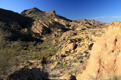
Remember how gloomy it was last Saturday? There isn't any rain in the forecast until Monday, so I wasn't worried about rain yesterday. We had the exact same pattern of clouds moving in from the southwest, though, and by the time I got out to Bulldog Canyon, the sky was grey.
The Supes on a gloomy day.
I didn't want to drive a long way on Saturday, so I headed for Bulldog Canyon. As I approached the Wolverine Pass entrance, I remembered the guy that didn't have a pass the last time I was out there and all the knuckleheads that break the lock and tear up the desert in that area and thought about going someplace else. I had about decided to turn around when I saw a ranger at the gate. He was checking passes as people entered. Hallelujah. It was good to see them doing something about the knuckleheads.
I'm going to walk up there somewhere.
The people that had passes and got in still drove places they weren't supposed to, but I won't get into that now.
I planned to go somewhere I hadn't exactly been before, just to see something slightly new. I headed up the side of a mountain. Part way up, I thought I could see a wall built near the top. I zoomed in and took a picture, and zoomed in on that and decided that maybe it wasn't a wall, but decided to wander in that direction until it got impossible or I got tired.
Does that look like a wall to you?
I kept thinking I should stop and turn back, and then I would think about looking at the pictures when I got home and realizing that it was a wall and I needed to go back up there to check it out, so I kept going. Eventually, I got to a point where it was getting dangerously steep. When I'm putting my hands on the rock as I'm climbing up, it's too steep. Fortunately, I have decided that it's just rock and not a wall.
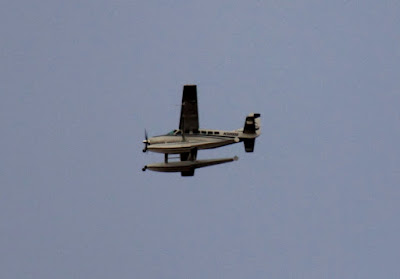
On the way down, I saw an air rescue helicopter fly over. I think it had come from somewhere in the Superstition Wilderness. I wonder if a hiker ran into trouble out there. I guess it could have come from the twisty road by Canyon Lake, too.
I also saw a plane with pontoons. You don't see those very often in Arizona.
Your landing options are somewhat limited in Arizona with this plane.
While taking photo point pictures near Roosevelt Lake, I had seen several things I wanted to check out further when time and weather permitted. It wasn't supposed to be raining on Saturday (it's strange how often I have to take that into consideration in a desert during a drought), so I went out there to look at a small canyon formed by Parker Creek. I did get sprinkled on a couple of times out there, but it wasn't enough rain to get anything wet. It was overcast and gloomy, though.
Parker Creek. Barely visible in the background is the scenic and more popular Parker Canyon.
The first thing I found when I got down to Parker Creek was a gold pan.
At first it looked like Parker Creek was dry. That's because it had gone underground. When I got to the narrow part of the canyon, which has a solid rock bottom, there was flowing water. That was also when the weather started to bother me. It was so gloomy. I was surrounded by grey rock with a grey sky overhead. It was also eerily quiet. I like the quiet of the desert, but it was just too quiet. There wasn't even a hint of a breeze. Near the water, you could hear it trickling over rocks, but that was the only sound. As gloomy as it looked, I wasn't very interested in taking pictures. Since the light wasn't good for pictures, I didn't want to go to the effort of clambering upstream very far.
Gloomy canyon.
A short video with the sound of the water.
There was another thing that I wanted to check out in that area. Northeast of the A-Cross ranger station (which is now closed and boarded up), there's a clump of green on the side of a large hill (must be a spring there). If you look at the area on Google Earth, it looks like there are two large, white rectangles in the middle of the green. I wanted to know what those what rectangles are.
As I drove back to A-Cross road, I noticed a small room built into the side of a hill. I had seen a larger one a little south of this one. A ranger tells me that structures like this were probably used to store explosives used to build A-Cross road. The crew working on the road was housed on the other side of the hill, safely away from the explosives. Something unusual about these two structures is the concrete roofs. Usually, the roof would be made of something flimsy so all the force of an explosion would go up, without launching rock missiles.
Explosives storage.
From the top of the hill with the explosives storage rooms, I could see a structure of some sort in the middle of the trees on the side of the hill northeast of the old ranger station. I was getting really curious about what it was.
The (closed) A-Cross ranger station, and something on a hill.
The road to the ranger station is closed, also, but I was able to get reasonably close. For most of the way up the hill, I couldn't see what I was looking for and just had to go in the direction I thought I should. That usually works pretty good, though. I came across a couple of low walls along the way. They must have been built in an attempt to control erosion.
A low wall on the side of the hill.
I didn't approach the spring from the best angle. I struggled through dense vegetation and a pile of plant debris to get to it. There's a fence around the area and the plant debris came from clearing out the fenced area.
My first view of the structure. A fence inside a fence? And how could this show up on Google Earth?
I could see a gate and worked my way over to it. There was a sign there that said, "BAR ELEVEN RANCH WATER SOURCE KEEP OUT". OK, I know what it is, but I still don't know what the big white rectangles are. I figured the "keep out" part was meant for people that might mess with their water and went in, being very careful not to mess with anything. I would have gone around the outside to see what was in there if it hadn't been nearly impossible to move through the dense foliage outside the fence. Anyway, the white rectangles are the cement lids over large tanks that capture spring water. Mystery solved. The fence at the back is to keep dirt from washing down and covering the tanks.
The white rectangles.
Turns out that there's a trail going up to the water tanks. I followed it on the way down. It was much easier than the trip up there. It was getting dark by the time I got to the truck.
As you enter Bulldog Canyon OHV area at the Wolverine Pass entrance (see the link to my map of Bulldog Canyon to the right if you're interested in knowing where that is), there's a low rock cliff on your right. I've been driving by that cliff for years and thinking that someday I was going to walk along the top of it. On Saturday, I headed for Bulldog Canyon planning to go someplace other than that cliff, but you know how I am.
The low rock cliffs.
There was some guy with some dirt bikes on a trailer hanging around the entrance. I had a feeling he was looking for somebody to open the gate for him. I decided that it was time to walk along that cliff and parked in the lot at the entrance. I was loading up when the guy came over with a sad story about getting to the ranger station just a couple of minutes too late to get a pass on Friday. There sure are a lot of people that are willing for me to incur fines and lose my pass on their behalf. He seemed like a nice guy, but I'm not going to take on risk for no possible benefit to help some stranger skirt the law.
He hung out there for a long time hoping to get in. An hour later some knuckleheads left the gate open, but this guy was gone by then.
The Wolverine Pass entrance is the entrance that's closest to town. Consequently, it's the most popular with knuckleheads. One road leaves the gate and splits into two, but the knuckleheads have made trails criss-crossing all over the place in that area. Before long, there's going to be nothing but bare dirt hills there. Anyway, I followed a trail made by dirt bikes towards the cliff.
The trail I followed is on the right side of this picture and goes through that shadow.
It was an easy hike to the top of the ridge, and there were nice views of the Superstition Mountains and Goldfield Mountains from up there. It would probably be a good place to get pictures of the city lights at night, too. There were fresh shod horse (i.e. not wild horse) prints along the top. Maybe people ride out there when they rent horses along Apache Trail.
Rocky view.
A view of the Superstition Mountains.
The scenery is nice in that area, but for the last hour I had to listen to the constant buzz buzz buzz of dirt bikes tearing up the desert. That's why I don't hike near the entrances very often.
I've been having a little trouble making blog updates lately. I've been distracted by an irresistibly cute 2-year-old. If she wants to play, I can't say no.
I knocked off two sets of photo points on Sunday. It's the ones that I didn't do a few weeks ago because I had forgotten to take the notebook with me. Park Creek was very easy. Just two photo points, not very far apart, and it didn't take me long to find them. I had looked at the location of the Reno Creek photo points in Google Earth and based on that and the reference photos, I thought it would be even easier than Park Creek. Silly me. I should know better than to think that.
It was easy to find the general area of the Reno Creek photo points, and they are all pretty close together. Two things threw me off, though. First, the reference photos had been taken after a fire that had cleared out a lot of vegetation. The plants have made a roaring comeback and visibility was severely shortened since 2006. Second, the hand-drawn map of the area doesn't quite match what is there. Maybe there are minor errors, or maybe the fence has been moved around a little. Anyway, I couldn't get to where I thought the first photo point should be. I finally decided to see if my phone had a signal and I had a 3G signal, so I opened up Google Earth and went to my location. I wasn't where I thought I was. No big surprise. I walked to where I thought I should be and then I was further from where I was supposed to be. Wow, it sure was handy having Google Earth with me as I wandered around. I decided to walk the perimeter of the fenced area and try to match the track on my PN-40 to the drawing in the notebook. The shape I got was sort of a mirror image of what was drawn. I think that was what caused a lot of my confusion. Now I was able to go directly to the first photo point. Well, almost. There are several very large sycamore trees out there. One of them had fallen on the first photo point. I got as close as I could to the correct spot. A tree in the reference photo that convinced me I was in the right spot is almost hidden now because of all the new growth out there.
After getting myself oriented and getting the first picture, I relaxed and sat down to have a snack. Remember when I was at another photo point location a few weeks ago and there were lots of birds and I knew there were some woodpeckers but all I saw of them was quick streaks as they flitted back and forth? Well, anyway, they were at Reno Creek, too. While I was eating, one landed on a narrow branch almost directly overhead and stayed there long enough for me to get a picture.
A Gilded Flicker, directly overhead. I'm glad there weren't any clouds up there or I wouldn't have gotten a decent exposure before it flew off.
The rest of the photo points went smoothly (except for the occasional fallen tree blocking a view). When I had been looking at maps before I went out there, I had seen that there was something called "Camp Reno" near there. Turns out there's a sign marking the general area. I decided to see if there were any ruins.
Camp Reno, occupied from 1868 to 1870.
As I was walking to the truck to leave the notebook there, I came across a couple of guys that asked me if I knew where Camp Reno was. I explained that I was just going to look for it. One of them shook his head and said, "Good luck". I guess they had been looking for it for a while themselves. Anyway, I was heading into the woods (it was kind of woodsy) when they drove by on their way out. They asked if I needed some water or a snack before they left. That was very kind of them. I told them thanks, but I have plenty. Afterwards, I got to thinking that their offer was just a little odd. If somebody was hungry or thirsty, they wouldn't be wandering off into the desert in search of a long-abandoned camp, would they? I thought a little more and realized that isn't the first time something like that has happened. On a couple of occasions, I've come across other people who looked concerned and asked if I was OK and if I needed anything. I wonder if it's the grey hair or if I just look much worse than I feel when I'm hiking. I'll have to try to get some pictures.
I didn't see any structures, or anyplace that looked like there used to be structures. There is an "Old Fort Reno" marker on the PN-40, so I stood in that exact spot and took a 360 degree panorama. Maybe you can find something in the picture. I couldn't.
Old Fort Reno. Well, its location.
Most of the 300 or so pictures I took that day went into the photo point pictures. Click below to see the rest.