Monday, June 29, 2009

Scorching heat, and clouds

It was another hot weekend. Too hot to hike. I decided to drive around a little yesterday afternoon to see if I could find anything to take a picture of. Something not too far away from my air conditioned truck. After all, I didn't want the camera to get too hot. You know, my Spot satellite messenger is the only gadget I have that is designed to operate at temperatures over 105 degrees F. I'm glad it is, but what's with all this other stuff? Why is it all made so wimpy? Canon sells a camera (the D10) that is advertised to be rugged. It can be dropped 4 feet without damage. It's water proof to 30 feet. It operates down to 14 degrees F, but only up to 104. My truck thermometer didn't show a temperature below 108 as I drove around. It was around 110 to 111 most of the time.


I wandered around a short time at the end of Idaho road to get some pictures. It wasn't long before my bottle of water was getting too hot to drink. The air was still. I tried to keep my camera out of the sun. There were some nice clouds around, though, and I wanted to get some pictures.


The really nice thing was that there were no gnats! I don't know where they go when it gets really hot, but I'm glad they do.


OK, it's time for another JPEG vs. pseudo HDRI comparison. Since I like to see detail in clouds, I think the HDRIs win this time.


Not much detail can be seen in these clouds.


Here you can see the detail.


This is a little interesting.


This may be over the top, though.


The clouds are completely washed out here.


This is better.


Blah.


Better.


Click below to see all of the pictures. Let me know what you think.


2009_06_28

Wednesday, June 24, 2009

Another hike on Everytrail

It was too hot to hike today (106 is TOO hot), so I sat around watching tv. Yuck. I finally decided to put another trip on Everytrail.


Cross Canyon hike at EveryTrail

Map created by EveryTrail: GPS Trip Sharing with Google Maps

Tuesday, June 23, 2009

Agave flowers and pseudo HDRI's

It felt too warm to go for a hike yesterday. I think it was only 102 or so. I guess I'm getting soft in my old age. I did wander around a little to get some pictures and the gnats, even though there weren't very many, were especially annoying. OK, I'll blame not going for a hike on the gnats and not my age.


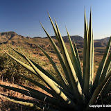
I wanted to get some pictures of agave flowers. I can't believe Skidplate didn't get any when he was driving out Apache Trail last weekend. That's where I went, and there were lots of agave flowers. It's one of those things that looks great but it's hard to get a good picture of it. That didn't stop me from taking pictures, though.


I also wanted to experiment with using a single RAW image to generate a pseudo-HDRI. Normally, I take 3 exposure bracketed jpeg images and use those to generate the HDRI. You have to stand very still, though, or use a tripod. Carrying a tripod is OK in cooler weather, but when it's hot I need to keep a bottle of water in my hands, and I don't like hiking with something in both hands. Having 3 or 4 hands would solve this dilemma, and many others, but I don't think that's an achievable solution. Plus, where would you buy shirts? Anyway, RAW images have a wider dynamic range than jpeg images. It's wider than the typical monitor can display. A pseudo-HDRI image takes advantage of that wider dynamic range of the source image to produce an HDRI. Using one image means I don't have to stand completely still for almost a second. It still takes forever to process, though.


I took all pictures using jpeg+RAW, meaning they were stored in both formats. I generated pseudo HDRIs for all of the pictures. The interesting result is that, at least for pictures of agave flowers, I prefer the jpeg. I need to try this with some cloud pictures, too. Let's look at some pictures to see what I'm talking about.


I'm not too crazy about the jpeg version.


But the pseudo HDRI version looks washed out, even though I adjusted the contrast. OK, maybe this is just a bad picture.


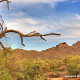
I like the way the sky looks in this one, but the buzzard is almost unnoticeable.


The buzzard shows up much better here.


This jpeg shows some detail of the buzzard.


If you want to see the details, though, the pseudo HDRI excels. BTW, I don't think I could afford a camera that could take three images of a flying bird for an HDRI.


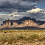
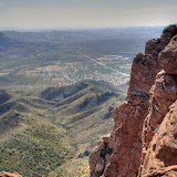
In this jpeg, the upper left is washed out, and the right side seems too dark.


I think I like the way the pseudo HDRI of this scene turned out better.


The flowers stand out in this jpeg.


The flowers are lost in the background of this pseudo HDRI.


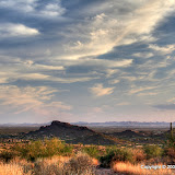
I like the deep blue sky in this jpeg.


Blah sky in the pseudo HDRI.


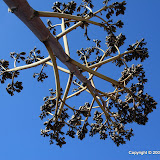
The artist in me likes the way the heart-shaped pad stands out in this jpeg.


The engineer in me likes all the detail visible in this picture.
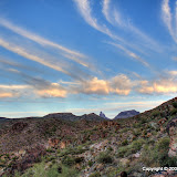


Nice jpeg.


Blah HDRI.


One reason I took this picture was because of the agave at the base of the saguaro. Did you even notice it?


In the pseudo HDRI, the agave stands out better.


At first, I couldn't decide if I liked the jpeg or the HDRI of this one. After 1.5 beers, I think the artist is winning and I like this jpeg.


You can see more of the agave here, but that isn't necessarily a good thing. (The engineer is still saying, "Yes it is. Yes it IS".)


Based on this small sample, it looks like HDRIs are good in only a small number of circumstances. I've only investigated a small number of circumstances though. I've learned a few things, but I need to experiment some more. Stay tuned.


Click below to see more of the pictures, including pictures of a couple of people that jumped off one of the one lane bridges over Canyon Lake.


2009_06_22

Thursday, June 18, 2009

Hieroglyphics Canyon Trail

Yes, I know, they're petroglyphs. I didn't name the trail. This is one of the first trails that I hiked in the Superstition Wilderness. I read about it first and looked for the petroglyphs while I was out there, but didn't see them. It wasn't until I got home and was looking at my pictures that I saw them. Now you know why my brother thinks I'll step on a rattle snake before I see it.


This is a fairly easy trail. It's about 3 miles round trip. It isn't very steep (except for a few feet at the very beginning). It's popular so you will almost always encounter other people out there. On this hike, a couple passed me on the way up. Later, when they passed me again on their way out, they were running. Sure, it's downhill, but in some spots it's very rocky. You would have to have great ankles to run on stuff like that. The first time that I hiked it, I thought it was a strenuous trail. I didn't know at the time that a few months of aerobic exercise was just the beginning; I thought I was in shape. It used to wear me out, though. Maybe it doesn't now because I stop to take so many pictures.


The parking lot is huge, and paved. No, I don't have a porta-potty in the back of my truck now. I'm just a bad photographer.


The main reason I came out here was to get pictures of clouds.


There wasn't anybody else at the end of the trail. I had all the gnats to myself. I guess they like to hang out near water. There's a spring there so there is almost always water. This was the first place I ever came across water in the desert, and I was astounded to see it just sitting there.


Spring-fed pools of water.


I took my time on the way back to the truck. It had been a cool day (probably below 95 when I started the hike) and it felt great outside as the sun sank. Some nighthawks flew around making their strange, monkey-like mating calls. Sometimes I'm glad when it gets too dark to take pictures because then I don't feel like I might be missing an opportunity for a great shot.


I didn't try to get pictures of the pink clouds that came later. I just enjoyed them.


I took a lot of pictures of the petroglyphs. Click below to see those and other stuff.


2009_06_17

Clouds and lost trails

There were cool clouds around all day, so after work I drove out to the Superstition Wilderness to see if I could get pictures of some. There were still a few around when I got there. I went a short way out the Dutchman trail. It was extremely quiet out there. The air was still and the honey bees had retired for the evening. I could hear a bird now and then, but that was it. It was wonderful.


Hanging fruit cholla flower.


I climbed up a hill and sat, enjoying the view and taking pictures. I took a lot of exposure bracketed shots for HDRIs. It seems that Photomatix has some trouble with either clouds or low light (where the only edge in all three pictures is the horizon). There wouldn't have been a problem if I'd used a tripod. I'll have to remember to carry it along on short, late hikes like this.


A lot of pictures in this direction couldn't be processed by Photomatix.


OK, there's the clouds. "But what's this about lost trails?", you ask. Remember that BMW session I had a week or so ago about the morons tearing up the desert in Bulldog Canyon? One reason that bothers me is because, if it keeps up, that area will be closed to vehicles. I ain't no spring chicken no more. If I'm not able to drive to a lot of the places I hike in there, I just won't be able to hike there anymore. So why do I bring this up again? Well, as I drove along First Water road to the trailhead, I passed the turn-off for the Massacre Grounds trailhead. The road out to that trailhead is very wide for a long way. The reason it's so wide is because, when it rains, all the yahoos that bought jeeps and trucks and then jacked them up so they almost need a ladder to get in, go out there to play in the mud. When you're doing donuts in slippery mud, it's hard to stay on the road. If you're a yahoo, you don't care because you want a wider road, anyway, so it's OK if you take out a paloverde, some cholla, or even a few saguaros. That road is also a favorite place for people to go target shooting. There's a big sign that says, "Congested area. No target shooting." The yahoos shoot it. They also bring their own targets, usually empty liquid Tide detergent bottles. No, I don't know why they are so popular, unless it's because they are so big. Sometimes they also shoot at their empty beer cans, though I suppose such a small target is hard to hit after you've emptied it, so they're usually just tossed aside. The National Forest Service has put a damper on all that good fun, though. There were three rows of dirt blockades piled up to block access to the road, and beyond them the road had been tilled to enable plants to get their roots started. They'll have to maintain the blockade weekly, though, because yahoos are stubborn and may not take the hint. At least 1.4 miles has been added to the Massacre Grounds trail. I may not be able to hike it again.


OK, that's it for this weeks BMW session. Click below to see the pictures.


2009_06_16

Monday, June 15, 2009

A real EveryTrail trip

I put together a regular trip on the EveryTrail site. There are some things I like about it (it didn't crash) and some I don't (no 3D view, but maybe I just haven't looked hard enough yet). Somebody out there tell me what you think. Somebody? Hello? Is anybody there? Oh well.


Apache Leap hike at EveryTrail

Map created by EveryTrail: Share GPS Tracks

Sunday, June 14, 2009

East of Superior again

There are a lot of places I haven't seen in the Oak Flat area (east of Superior), so I went out there again on Saturday. I could see another stock tank on Google Earth, near Apache Leap, so I went to check it out. Well, mostly I went to check out the view from there.


I thought I could see a trail on Google Earth, and when I got there I found a wide path heading up the canyon. It looked like I could have driven up there. It wasn't too long before I got to some large boulders that my truck could not have gotten over, though. It seemed that somebody must have driven a bulldozer up there at some time, though. The construction of the stock tank involved moving a lot of dirt and rock. I doubt that was done by hand. I did see some large rocks along the way that had been broken into several pieces, probably from a bulldozer going over them. At one point I also saw a tire track in the sand. Somebody had driven a jeep up there not too long ago. Mine were the only human footprints I saw, though.


At first, it looked like it would be an easy trail to follow.


This area seemed to be more overgrown than the trail to Apache Leap. Also, there were very few cairns and they were widely space. Most trail markers seemed to consist of green tape tied in bush branches. I think that was put there by jeep drivers.


The trail splits here. I went to the right.


There was a strong breeze blowing down the canyon for most of the hike. And, like last time, I knew I was close to the cliff edge when the wind really picked up. When I got to the stock tank, there were a few cows hanging around there. By the time I pushed through the brush to get down there, I had scared the cows off.


Skittish cows.


Between the stock tank and the drop off (it isn't as much of a cliff here), somebody had built a wall by stacking up rocks. It must have taken a lot of work. Seems like it would have been easier to string barbed wire. There was a barbed wired gate in the middle of it.


Rock wall.


I felt energetic enough to take a different route back to the truck. Also, I wasn't as worried about being out here after sunset. All I had to do was go downhill until I hit the road. The route down started out easier than the route up, but it didn't stay that way. It was very overgrown. I would either have to climb over rocks or push through bushes. Climbing could lead to falling, so I pushed. Oh, there are lots of catclaw acacias out there. I was a bloody mess when I got to the truck. It's not that I got big cuts, or a lot of them. You just don't want to stop and mess with tiny scratches. I don't carry enough water to wash the blood off. So the blood trickles down my arms. When I stop to take pictures, it seems I put my arms against my body, so that gets my shirt bloody. I wanted to get a beer on the way home, but I didn't want to walk into a store looking like I did.


There was an unexpected benefit to taking the other route back. A couple of weeks ago I was thinking that I needed one of those geologist's pick things. You know, the hammer type thing they use for breaking rocks. I found one half buried in the sand. Nifty.


Just what I needed.


Click below to see all of the pictures.


2009_06_13

Saturday, June 13, 2009

Thursday, June 11, 2009

Not so fun anymore

I've enjoyed going to the Bulldog Canyon OHV area for years. Lately, though, it sometimes puts me in a bad mood. Actually, it isn't the area itself; it's the people, and the evidence of people. I think that only a very few of the people out there go for the scenery. They go to ride noisy machines to the limits of safety (and sometimes beyond, judging by the smashed plants). The rule to stay on designated roads doesn't suit their idea of fun, so they rip new trails wherever they please. They drop their beer cans wherever they are emptied. They build "campfires" with flames jumping 10 feet high when the posted fire danger is "EXTREME". Well, I could go on and on, but I'll stop my BMW'ing now.


I finally got a polarizing filter for my 18-200 mm lens and went out there to try it out. Clouds moved in, though, and there was almost no blue showing by the time I got out there. I took a few pictures anyway. Click below to see them.


BC_2009_06_10

Monday, June 08, 2009

Apache Leap trail

On Saturday, I tried to get to Apache Leap, but I hardly made any progress at all. I was looking at the area in Google Earth, trying to figure out how to get past all those huge boulders. Then I noticed a stock tank very close Apache Leap. Somebody had to put that there, and they probably went up there now and then, so there had to be a way to get there. Looking at the valley in which the tank was located, I thought I could see a trail. Maybe it was wishful thinking. At least it looked like there weren't as many huge boulders there. The usually problem with areas like that, though, is all the vegetation. But if there's a trail, there will be a path through the vegetation.


So I drove out past Superior again. It's a beautiful drive from Phoenix to Superior. The road from Superior to where I turned off (Oak Flat Campground) is spectacular. I'll have to take some pictures some time. Anyway, I parked in the same place I did before and walked down to where I thought the trail should be. Lo and behold, there it was.


It would be easy to miss the turn-off for this trail.


At its beginning, the trail was narrow; bushy oaks brushed my shoulders and legs. I didn't have much hope of such a seldom-used trail getting me to my destination.


The entire trail is marked with frequent cairns.


At the beginning, the trail frequently crossed sandy or dusty areas. The only human footprints I saw were mine. It's obviously not a heavily used trail. But there were lots of cairns. I was almost always within view of at least 3. Somebody put a lot of effort into putting those things up. At times they were the only way to tell where the trail went. It was hidden in spots by this past spring's growth.


This area is a lot different than where I'm used to hiking. There are a lot of different plants. I noticed manzanitas with berries on them. Then I noticed poop on the trail with manzanita berries in it. I don't know what animal did that, but I imagined that it was black bears. I know there are a lot of them around Four Peaks, so they may be here, too. I would love to get a picture of a bear. I would hate to surprise a bear. Hikers are advised to make noise as they hike so bears will be aware of their approach. I'm not normally a very noisy guy, but I decided I had better be for a little while Every once in a while I stopped and did my impression of a large dog barking. I've gotten pretty good at it. It fact, a couple of times when I heard my echo, I picked up a rock to bean that mean dog.


The trail was overgrown in lots of places. Also, there were a few times that I wasn't paying attention (imagine that) and lost the trail. The point is, unless you really enjoy bleeding, wear long pants on this trail. There's lots of catclaw acacia. There are a lot of other sharp things, but they pale in comparison to the catclaw. My arms were covered with dried splotches of blood by the end of the hike.


The stock tank I saw on Google Earth.


It's only about a mile hike to Apache Leap. It seemed to take a long time, though. It's about a 1000 foot climb but didn't seem steep at all. It was a very enjoyable hike. BTW, I've hardly seen any gnats since I got back from Texas. They must have starved to death while I was away. It was exciting when I got to the stock tank, because I knew I was very close to the cliff.


After passing the stock tank, I wasn't sure how close to the cliff I was. Then I noticed the wind whipping some agave flower stalks around. I knew I was very close. A couple of more steps and I could see Picketpost Mountain in the distance.


Campers built this wall to shield their fire from the wind.


The wind and the view reminded me of the South Rim of the Chisos Mountains in Big Bend, though not quite as spectacular. The breeze felt great, and the view was very nice.


Unfortunately, I was shooting into the sun.


The Superstition Mountains and Weaver's Needle can be seen on the horizon. Yes, there are more cairns over there.


My pictures do not begin to capture what it was like to be up there. You'll just have to go with me some time. Click below to see all of the pictures.


2009_06_07