Thursday, March 31, 2011

A trip to the Rolls

Skid sounded bored on Sunday, so I suggested that we go riding. I wanted to go someplace east of town, but the Renaissance Fair isn't over yet, so we went to the Rolls.


I was worried that it might be hot, especially since we started out early in the afternoon. I put the top on the Ranger, though, and it was comfortably cool in the shade.


The ground was carpeted with tiny yellow flowers.

As I was getting ready to leave the parking area, I couldn't find my GPS holder. I suppose I could have run with batteries and stuck the receiver in my pocket, but I decided to just not mess with it. As a consequence, the pictures are geotagged.


Scenic views about.

Near Brownie tank we found a smashed vehicle. Hard to tell what it was. That was the most exciting part of the ride for Alex.


All we did was sit all day, but I got kind of worn out by all the bouncing around. I think Skid did, too. Click below to see all of the pictures.

2011_03_27

Sunday, March 27, 2011

Sandy and Poopeck

No, I didn't miss-spell poop-deck, but we'll get to that later.

A couple of years ago, I had hiked to a spot on the Salt River bank that was covered with river rocks and as I stood there, dozens of spiders came up from between the rocks. I got a few pictures of them. I decided to go back there to see the spiders again.


I followed vehicle tracks most of the way this time.

There are lots of vehicle tracks over there. The public isn't allowed to drive there, and the public doesn't drive there. I suppose all the tracks are from sheriff's vehicles, game warden's vehicles, emergency vehicles, etc. This is where drunks come to test their survival skills by seeing if they can sit in an inner tube while if floats down the river. It's a challenging task and several drown every year. It's too early in the year for that now, thank goodness. The river is still very low, too.

I did find a few spiders. Maybe it's still early in the year for them, too. I saw very little trash. I think some volunteer group must have cleaned up out there recently.


I saw a few cranes. There's one in this picture. Didn't get any good pictures of them.

I think Sandy and Poopeck were somebody's pets. Their graves were at the edge of a wash. I wonder what it's like trying to dig a hole out there. Most of the ground is very rocky. I suppose the graves were near the bottom of the wash because of the sandy soil there.


Sandy and Poopeck.

Click below to see all of the pictures.

2011_03_26

Monday, March 21, 2011

Bulldog Canyon and lunatics

Several people from work had planned to spend a weekend in Bulldog Canyon OHV area this past weekend. I figured I would join them during the day but when I'm that close to home, I'd just as soon spend the night in my nice, soft bed.


A view of the Supes from near the campsite.


The campsite.

On Saturday afternoon I was at the camp site and Vincenzo was going to go for a hike. I asked if I could go along and then I told him where we should go. Gee, that doesn't seem polite. Well, I suggested a place to go and he was agreeable. A few weeks ago, I had been on top of a hill in the same area and had seen a house foundation. The camp was about due south of where I thought I remembered the foundation being, so we headed north to see if we could find the foundation.


We found the foundation without too much difficulty.

We found the foundation, and we found out that it was a popular place for target practice. The "marksmen" had left their targets (aka trash) all over the place. You could hardly see the dirt around the foundation for all the shells. Vincenzo was disgusted and I felt bad for taking him over there. Still, it was a nice hike. I didn't take a lot of pictures because I was trying to keep up with Vincenzo.


We also found a small exploratory "mine".

We sat around the campfire telling stories and cooking for a while. Jay has some very interesting stories, many of which involve aliens. Yes, this is Arizona, but he wasn't talking about citizens of Mexico. He was talking about the kind from other planets. He also talked about witches because of the full moon that night, which coincided with the equinox and also happened to be occurring when the moon was at the point in its orbit when it's closest to the earth. Whenever a vehicle passed by the camp, he told us to check and see if they were carrying live goats and if so, we needed to be careful in case they wanted to add a human sacrifice. This was all very entertaining, but I didn't expect to see anybody out there for the rising of the full moon. Boy, was I wrong. I headed for the truck just before sunset, since it was getting a little coolish. I was driving the Ranger and the truck was at the Packsaddle entrance. I got the Ranger loaded up and headed out on what I expected to be a deserted road. I came over the first small hill and there were cars everywhere. It's bad enough trying to dodge potholes along that road, but I also had to dodge cars and lunatics. Yes, they were all out there to watch and get pictures of the moon rise. So far, Skid is the only person that has laughed at my lunatic joke. Either people don't get it or it isn't very funny. Probably the latter. I would have taken pictures of them but it was dark. I wanted to get some pictures of the moon rising over the Superstition Mountains but there was no place to park where the view was the best, or even where it was bad. That's OK. I'll go get my picture in 27 days. Click the two things below to see what pictures I did get.

BC_2011_03_18

BC_2011_03_19

Monday, March 14, 2011

A shorter hike

Sunday was another beautiful day so I had to get out and do something. My ankles were still a little achy from Saturday's hike. I didn't want to hike a long way. I decided to climb something.


My original plan was to climb this, maybe from this side (looks doable from here), maybe from the other side.

As I got closer to what I planned to climb, it looked less climbable. Maybe I could climb it from the other side. When I got over there, that side looked pretty steep, too. Well, I didn't go out there to struggle. I kept walking down the wash, looking for something else to climb. I got almost to the rock wall I climbed about a year ago before I found a gentle slope and started up. I didn't care if I got to the top of anything. I just wanted to climb for a while.


I'm going in that direction.

If you look closely at that last picture, you'll see that the rocks at the top of the cliff are black. Everything below them is very light colored rock. Everything except for the rocks that had fallen from up there, that is. Any spot that was level enough that pebbles up to refrigerator size boulders would stop rolling was littered with black rocks. I know that the dark rocks weren't released from the light rock by weathering because there are no dark rocks embedded in the light rock. So why all this discussion about the black rocks? Because you can tell that some of them have been sitting in the same place for a very long time. I don't know how fast that light rock erodes in the desert, but I would bet that some of those rocks have been sitting where they are for at least hundreds of years.


A prime example of a rock that has been in one place so long that the rock under it has eroded away to just a small pedestal.

I don't know what eroded the light rock away, either. You might think that rain falling could easily leave the pedestal. If that was the only cause of erosion, then those rocks have probably been sitting there for thousands of years.


I got high enough to have a view of the Superstition Mountains. I climbed around on that rock in the foreground when I hiked up to Richard's Arch a few weeks ago.

Much of the light rock is covered with thin soil and moss. The moss could grow right up to the black rocks but of course could not grow under them. I believe the moss helps break down the light rock into soil. As it "ate" away at the light rock at the edges of black rocks, it was able to undercut the black rocks and eventually leave the black rock on a pedestal. There is no moss around the black rocks in my pictures, though. Well, there are large areas where the rock is bare. I think cattle could have tromped around up there (there is a stock tank nearby, and barbed wire fence) and their weight would have broken up the fragile moss and soil, making it susceptible to erosion by rain. The pedestals are created by plants converting the light rock to soil and revealed by soil erosion caused by cattle brought here by Europeans. Couldn't deer have damaged the soil? Well, I rarely see deer footprints anywhere but in sandy washes (they are lighter) and I don't think deer are as concentrated as cattle tend to be. The number of deer would have been kept in check by mountain lions and wolves, but those predators were wiped out to protect cattle. I may be full of beans, but I think it's an interesting idea.


Down there is the rock wall I climbed on a very warm day last summer.

Click below to see all of the pictures.

BC_2011_03_13

Sunday, March 13, 2011

In the middle of nowhere

There are places in Bulldog Canyon OHV area that look like they would be interesting to explore, but I haven't been there yet because they are hard to get to. There are also places I haven't explored because they look boring. I didn't want to do a lot of climbing yesterday, so I went to one of the places that looked like it would be boring. It's a large, mostly flat area. Well, flat compared to mountains. I studied the area on Google Earth and the most interesting thing I could see there was a small patch of light colored ground. I've looked into such things in the past and sometimes they turn out to be old mines, so that would be my destination. I even saved the coordinates in my PN-40 in case I had trouble finding it.


I knew there would be plenty to get pictures of out there.

As I started out, the desert smelled wonderful. It still had a little bit of that fresh creosote odor from the rain a couple of weeks ago. There was also something sweet mixed in with it. I didn't see many flowers, though. As I walked by a paloverde the sweet smell was really strong. This paloverde had a lot of parasites (similar to mistletoe) in it. The parasites were covered in flowers almost too small to see. I think that's where the sweet fragrance originated.


Paloverde full of parasites.

I came across some light patches of soil that I had seen in Google Earth. It was just different colored rock. Not too exciting. They didn't stand out as much as the one I was headed for, though.


Light colored rock.

I climbed a small hill and thought I could see my destination. It didn't look very interesting from the hill, but I had to be sure.


Looks like just another patch of light colored rock.

It turns out that it was mildly interesting. Somebody had dug a hole there and spread the light rock around, which is why it stands out in Google Earth. The hole is about 6 feet deep at its deepest part. The hole is why the center to the light patch looks dark on Google Earth.


A hole in the ground.


It isn't very deep.

I climbed some hills north of the hole to check out the view and found a Y saguaro. These are supposedly rare but I seem to find them all over the place. They aren't as rare as crested saguaros.


A Y saguaro.

I took lots of pictures of saguaros and sticks on this hike. I was trying to be selective about what I photographed, but everywhere I looked there was something pretty. It was a very enjoyable hike.

I saw tiny flowers scattered here and there, and about 5 Mexican Gold Poppies. I had read in the paper that the rain didn't fall at the right time for good spring flowers and so far that seems to be the case. Click below to see all of the pictures.

BC_2011_03_12

Friday, March 11, 2011

Saguaros

As you drive downhill on Usery Pass road towards Bush Highway, you often see vehicles parked along the side of the road. It doesn't look especially interesting on either side of the road, but I thought there must be something there to attract all those people. Silly me. I went for a short hike over there yesterday and now I know why so many people stop over there.


A clue.

What you see in the picture above is a capacitor. It came out of a TV. No, people don't go out there to watch TV. They go out there to shoot TVs. They also shoot their empty beer cans and bottles and lots of other trash. Mystery solved. BTW, I know the cap came from a TV because I also found the yoke off the tube.


A saguaro.

There are also large saguaros in that area. Surprisingly, they are not shot up. I guess people bring enough trash to shoot out there that they don't have to resort to shooting saguaros. When I left the truck, I was thinking that I wouldn't be taking many pictures. I wound up taking a lot of pictures of saguaros, though.


I also took pictures of a large ocotillo.


Stewart Mountain.


Took pictures of some sticks, too.


Saguaros.


Large saguaro.


It seems very green out there.

I'm going to go out there again. I need to start out a little further north, to avoid a lot of the pointless ups and downs around Lone Mountain. I may find something intriguing yet. Click below to see all of the pictures.

BC_2011_03_10

Monday, March 07, 2011

Smoother roads in Bulldog Canyon

Lindsey and Jon have been wanting to go for a ride in the Ranger. On Sunday, schedules and weather finally worked out so we could do that. I wanted to go someplace scenic, so we went to Bulldog Canyon.


This hole in the ground has a concrete side with re-bar steps in it.


Lindsey wanted to climb up to this arch. Looks a little risky to me.


We thought she would stop when she got here, but she kept climbing, with both Jon and me telling her to stop. She finally decided it was too risky and came back down. It was so strange. It's the guys that are supposed to be doing stupid stuff, not the girl.

The bulldozer is still working on the roads in Bulldog Canyon. It has smoothed 1356 from where Lindsey went climbing west to where it meets 10. The entire length of 10 has now been bulldozed. We took 10 down to 3554 and I was amazed at how fast I could travel on that road. Lindsey got tired of me saying, "This is so smoooooth!". Oh, if you are interested in knowing where all the roads are, check my map of Bulldog Canyon.

Lindsey wanted to stop by the Ring Bearer's cache. She and I accidentally found it back in 2006, when she used to go on hikes with me. It's still there, and a lot more people have found it. It's a little surprising how many people have wandered up there.


People have built a fire ring and other stone walls now. I wonder if the heart shape (upside down from this angle) is intentional or an accident.


Lindsey makes a new entry in the log book. I wonder what she wrote.

On the way back to the truck, a coyote trotted across the road in front of us. It stopped in plain sight and turned to look at us. I stopped and grabbed my camera and it actually stood there while I took a few pictures. I was sure the sight of a camera would cause it to bolt.


Coyote posing for pictures.

Click below to see all of the pictures.

BC_2011_03_06

Tuesday, March 01, 2011

More snow

I had been reading the weather forecasts last week. I knew there was going to be snow. Some forecasts said it would be as low as 2500 feet. Still, on Sunday, after listing to rain all night, I didn't think about going to look for snow. Just before noon, though, I got a call from somebody saying that I should take a look at the Superstition Mountains. So I grabbed my backpack and my camera bag and headed out the door. Forgot to eat lunch. Sure enough, there was quite a bit of snow on the Superstitions. There was also a very large, very dark, very ominous looking cloud coming from the northwest that was dumping something (maybe more snow) on the Flatiron, at the western end of the mountains. I probably should have taken a picture, but I don't like taking pictures in town. Power lines and light poles in my pictures really annoy me, so I try to avoid them.

I drove all the way out to the Hieroglyphic Canyon trailhead, even though I knew I would be too close to the mountains to get good pictures. I figured that I probably had enough pictures of the Superstitions with snow on them and I just wanted to look around. Of course, I took pictures, too.


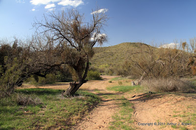
The view from the Hieroglyphic Canyon trailhead. The Flatiron, and the black cloud over it, are out of view to the left. It's getting dark here, though. Damp snowflakes were hitting me before I left.

It looked a little sunnier to the east, and I could see a lot of snow on the mountains in that direction, so that's where I went. D**n the Renaissance Fair traffic and full speed ahead. Actually, I think a lot of people decided that it wasn't a good day to go to the fair. There wasn't much traffic at all.

I've always wanted to get a good picture of Picketpost Mountain from the west. With snow on it and the sun peeking through the clouds now and then, it would make a nice picture. The trouble is, there isn't any place to park with a good view of the mountain. I don't like the idea of parking on freeway shoulders unless it is absolutely necessary. I found a place to get a hundred feet or so off the road (and almost got stuck in the mud) but couldn't see the mountain. I was hoping I could after climbing a small hill, though. Before I started out, I looked back at the storm. I had gotten a little ahead of it, but now it was catching up with me again. I would have to hurry. I moved quickly to the top without taking any pictures of all the cool stuff I saw on the way up. Well, OK, I took a picture of a saguaro skeleton with snow on it. On the way up, I kept hoping that I wouldn't see another hill between me and Picketpost when I got to the top.


Not a bad view of Picketpost, but the clouds are catching up with me; no sun on the mountain.


Superior. The dark band above it is Apache Leap.

While I was on top of the hill taking pictures, the wind picked up. I had made sure I had at least one poncho with me before I left the house, but being caught in a storm when it's in the 30's wouldn't be fun. I hurried back to the truck and drove on in to Superior.


The storm approaches.


The rest stop in Superior. This is a lot of snow by Valley of the Sun standards.

I was too chicken to continue going east from Superior. The road climbs a thousand feet and I didn't want to drive on any snow, so I headed south on 177.


Looking back towards Superior from 177. The mountains north of it are hidden behind a wall of white.


Snow on saguaros.


A non-HDRI shows how dark it is to the north.

177 climbs gradually for a few miles, then climbs steeply to a pass. There are truck safety pullouts at the top on both sides of the pass, and each had a few people out looking at the snow. I stopped at both to take some pictures and was pelted by tiny balls of snow. I suppose there's some technical name for that kind of snow but I see snow so seldom I'm not going to bother looking it up.


It was snowing in front of me and behind me as I drove south.


A small open-pit mine made slightly less ugly by the snow.


Snow capped saguaros. That seems so out of place, kind of like a bikini at McMurdo Sound.


Snow at the mountain pass. I also took a picture of these people with their camera so they could all be in the picture.

On the south side of the pass, the road descends into the Gila river valley. Of course, there was no snow down there. I went a very short distance down Battle Ax road and climbed a small hill there to get some pictures. The clouds were clearing by then but there was a strong breeze from the north. I stood at the top of the hill for a couple of minutes taking pictures of the mountain to the east and was a little scared when I quit and it felt like the left side of my face had frozen into the goofy expression I make when I'm taking a picture. It thawed quickly when I got out of the wind. Whew.


That cloud looked awesome.


Landscapes look great in the clear winter air. The edges of these clouds look strange. I wonder if it's an HDRI artifact. I'll have to check the original pictures when my NAS isn't so busy (long story).


The wet ground and clear air made the Ray mine look especially colorful.

By the time I started back north, it was clearing over Superior. It was such a nice day, I decided to go east on 60 after all. The road was heavily traveled and completely clear.


Clear sky towards Superior.

60 climbs a canyon east of Superior, and it's very scenic there. There's a tunnel at the beginning of the climb where I've always wanted to take some pictures but have never stopped. I stopped this time, though, since I wasn't in a hurry to get someplace else.


At the uphill end of the tunnel.


The tunnel.

The area at the top of the canyon is called Oak Flat. In such rugged terrain, flat areas are rare and they always seem to have a name. Being flat, it had lots of snow and also lots of people playing in it. I went past there on Magma Mine road and took some pictures of snow on all the rocks. I kept thinking I needed to work on being more artistic with my pictures of the snow instead of just showing what was there, but my pictures are rarely, if ever, artistic, so I don't know why I kept thinking that.


An almost artistic picture of snow on a rock.


This almost looks a little artistic.

By the time I got back to the western side of Picketpost Mountain, the sun was shining on it and the snow was quickly melting. I took a few pictures from the road to the Picketpost Mountain trailhead.


It didn't take long for the snow to melt.

The sky was clear over the Supes when I got back there, and there was just a thin line of snow at the very top. I thought about getting some pictures from Silly Mountain, but by then I was way too hungry. I ate all the beef jerky in my backpack but it just wasn't very filling. Click below to see all of the pictures.

2011_02_27