Wednesday, December 18, 2013

A different view of Canyon Lake

I've always wanted to see what Canyon Lake looks like further upstream. I looked into renting a boat but that is outrageously expensive. I think about buying a kayak but I worry that the lake might be much larger from the perspective of a kayaker. Then there's the obvious solution; hike. I've looked at that area on maps and Google Earth, and there's even what looks like a road going where I want to go. I've hiked along that road two or three times but always turned back before I got very far because of heat, approaching darkness, or gnats. Well, this is another one of those "while I can" hikes, and the weather is perfect this time of year, so off I went.


It still hasn't dried up completely since the last rain.


I always take lots of pictures of this mountain when I'm in this area.

I figured I would follow the road as far as it went, and then see if I could get to the top of a nearby hill that should overlook that part of the lake. It turns out that it really is a road. At least I think it might be. It's very lightly traveled. It had one set of recent tire tracks when I was out there. They were so fresh, I thought I might find a truck at the end of the road.


Here's a saguaro and that mountain.

Before I even got to the end of the road, I started to worry about how late it was getting. I couldn't turn back, though. I had flashlights I could use on the way back if I had to. When I got to the end of the road I could see that it would be easy to get to the top of the hill that was my destination. As I was going up the hill (a gentle slope with only minor obstructions), I came across a freshly chewed prickly pear pad. I figured that meant that there were javelinas nearby. A few steps later I was walking around a prickly pear when a dead paloverde branch tried to push me into the prickly pear. I pushed back and the branch snapped with a loud crack. That set off the javelinas that had been standing quietly about 100 feet from me. They snorted and stomped and snorted and stomped away down a ravine. All but one, that is, and it hung around a few seconds so I could get a picture. Grunting javelinas sound a lot like guys in their 20's that are trying to sound like cave men. The next time I see some I think I'll grunt like they do and see what happens. Some javelinas, that is. Hmm, maybe they'll feel challenged and charge me.


Javelina wondering what all the fuss is about.

I went up the side of the hill that didn't have a view of the lake, but the view was impressive. I was distracted by it for a while before I got over the top of the hill.


A nice view before I reached my destination.

At last I got to the top of the hill and the view of the lake was as impressive as I had imagined it might be for the past 5 years.


A view of Canyon Lake that few people see. No, boaters don't see it, because they don't climb this hill.


The view is also very impressive to the north of the lake.


The road.

I wanted to hurry on the way back. The sun officially set about 20 minutes before I got back to the truck. I couldn't hurry much, though. I've slipped a couple of times in the past on that road. By the time I got to the steep downhill parts during this hike my legs were pretty tired, so I was moving kind of slow. It was 4.9 miles round trip, with about 1200 feet of ups and downs. The views were well worth the hike but next time I might see if I can drive on that road. Click below for all of the pictures.

2013_12_14

Wednesday, December 11, 2013

Black Cross Butte

This is another one of those hikes that I've been meaning to make for quite some time but have decided I had better get it done before I fall apart. I think I searched the web for a route to the top long ago and the only description I found talked about climbing (hands and feet) and hopping along the tops of hoodoos. Well that's just crazy. Then a year or so ago somebody told me about an easy route to the top. He was on his way up there with his whole family, including little kids. Google Earth is high resolution in that area now, and I can even see the trail on there. It isn't an official trail, but it'll do.


We started the hike with a stop at the tall skinny rock. Well, this is a family-friendly blog.

My older sister's husband went with me. They've been in western New Mexico the past few months and have done a lot of hiking out there. I was afraid I would be slowing him down but it didn't work out that way.


I took this picture because of the reflection off the water but then I noticed the rock on the right that looks like it's winking at you.

For some reason, I always think of the first part of this trail as being almost level with a few ups and downs. You climb 400 feet on the first part but probably go up and down 700 feet in the process. I'm always tired after hiking out there and blame it on distance, but I think it's really all the ups and downs.


Looking across to the hill I climbed back on November 17.

About 0.8 mile into the hike, Willie declared that his legs were tired enough. He's used to hiking with Julia, and she gives him many more opportunities to rest than I did. He told me I could go on if I wanted to and he would meet me back at the truck. Well, at first it seemed rude to go off and leave my tired guest alone out in the middle of nowhere. But he sounded sincere, and he's a hunter that has spent many days alone in the wilderness. I knew he wouldn't have any qualms about being left alone and would actually probably enjoy some solitude. I also knew I didn't have to worry about him getting lost or climbing something he couldn't get down from or falling off a cliff. Of all the people I know, he's probably the most capable person to leave alone someplace that he's never been before. So I did.


It's surprising to me that this shows up so well on Google Earth.

The rest of the route to the top was all climbing, but it wasn't difficult even though it was another 400 feet up from where I left Willie. The view was as good from the top as I had suspected it would be.


This was taken from somewhere in the middle of the top. I had to go to the edges for the really good views.


Is this THE black cross of Black Cross Butte? This actually shows up on Google Earth. I didn't notice what looks like the grassy outline of a building foundation until I was home looking at pictures. I may have to go back.

I spent less than half an hour on top. The temperature was below 50 and the wind was blowing 10 to 15 mph. I had to keep moving or I would freeze. Hey, I'm used to 105. 50 is colder than I like. It's hard to keep moving fast enough to stay warm on almost level ground covered with ankle twisting rocks and shin stabbing agave and evil prickly pear. I did bump into a prickly pear up there, but I was able to remove all the thorns without taking off any clothing first.


A lot of the butte looks like this, which is why I thought it would be difficult to get up here.


Here's a picture looking down at where the truck is parked. I'm only about 700 feet above it.

I made several panoramas from the top. They aren't in the web album. I put them on my Panoramio page. All but one are full resolution, so you can zoom in quite a bit.

I had my hiking stick with me on this hike, and was glad I did on the steep down parts of the return hike. I was very tired by the time I got back to the truck (where Willie was waiting patiently). I pulled the GPS out of my backpack and was shocked to see that I had hiked only 3 miles.


This is Teddy Bear cholla. I guess it's called that because it looks so cuddly. When viewed under a microscope, the spines can be seen to be made of backward facing scales, kind of like fish scales. They go into skin easily but are difficult to pull out.

I had started the day on my feet for a couple of hours. I was a little hesitant to go on this hike after that, but the sun was shining. This time of year, it could be gloomy and overcast by the next day, so I went. It was difficult to walk the next day but worth it. Click below for most of the pictures.

2013_12_07

Sunday, November 24, 2013

While I can

My left ankle has been bothering me for the past few years. In the big scheme of things, it's a very minor issue. It currently limits my hikes to about 5 or 6 miles. It doesn't bother me much while I'm hiking, but the next day it may be very difficult to walk. Lately it has gotten me to thinking about some hikes I've been on in the past 10 years that I should not do now. Then I got to thinking about hikes I could do now that I may not be able to do in a few short years. I'd better do them now.


Going up to that peak is one of those "some day" hikes.

A couple of weeks ago, I had hiked off-trail near Fish Creek Hill. I turned back when the sun started getting low, but continuing to the top of a hill where I turned back was something I wanted to do "some day". I decided I had better do it while I could. It's a 1.3 mile hike to the start of the climb, then a climb of about 350 feet in 0.3 mile. That's not much of a climb, and the hike before it doesn't have a whole lot of ups and downs. Various things have kept me from hiking lately, though, so I'm not in top shape.


Based on what I had seen the last time I was out there, I was sure that the view from the top would be worth the climb.

It seemed like I had been hiking for a long time by the time I got to the start of the climb. I knew I was going to be very tired by the time I got to the top. I had to go, though. I allowed myself to believe that the false summit I saw from the base was my actual destination. The climb is only moderately steep.


This gives you an idea how steep the climb was. Unfortunately, saguaros are rare in this area so I don't know if I had my camera level for any of the pictures.


I wonder if it's possible to get on those mountains back there.

I decided that if my legs were too wobbly on the way down, there were plenty of agave and sotol flower stalks around to use as walking sticks. I was determined to make it to the top. When I finally reached the top and saw the view, I felt that it was well worth the effort. There are some beautiful sights as you drive along Apache Trail, but very few people get to see what I was looking at.


My first view from the summit. That's Tortilla Creek on the left.


After the clouds rearranged themselves.


Canyon Lake is 5.7 miles away. Stewart Mountain, on the right, is 13.5 miles away.


The ridge in the foreground is the top of the hill I'm on. I didn't walk along there. Maybe I should. Soon.

Getting back down was easier than I thought it would be, and the walk back to the truck wasn't so bad, either. I sat down a couple of times to get grass seeds out of my shoes and didn't want to get back up, though. I could still walk the next day, too.

I drove almost a mile along FR 213 to get to the start of the hike. The first quarter mile of that drive is *extremely* rough. There are parts where you feel like the truck is going up at a 60 degree angle, though I'm sure it can't really be that bad. You have to creep along at about half a mile an hour and choose your path very carefully. The road is narrow but much smoother and less steep the rest of the way. Well, it used to be. I was just about to my parking spot for this hike when I encountered some hikers walking back to the parking lot at Apache Trail. They warned me that the road gets pretty gnarly up ahead. It must have gotten washed out by some storms during the past year. Remember the MCSO helicopter that buzzed me several times the last time I was out here? Well, now I'm wondering if maybe somebody had rolled their vehicle further out that road. Click below for all of the pictures.

2013_11_17

Saturday, November 09, 2013

Off FR 213

I've been taking some sunset pictures lately. I usually set the ISO, shutter speed, and aperture when I do that. The trouble with doing that is that I sometimes forget to take the camera out of manual mode before the next time I use it. Also, I don't usually look at my pictures as I'm taking them, so it can be a long time before I notice that something is wrong. I was halfway through this hike before I noticed that most of the pictures were over-exposed.

I was driving along Apache Trail trying to decide where I should hike when I saw a hill that looked like it was in a good place to explore. I wasn't even sure I would be able to get close to it, but it turns out I could drive to where there were no canyons between me and the hill. I parked along FR213, which is a very rough road that is only one vehicle wide for most of its length. FR213 goes into the Superstition Wilderness. The wilderness boundary is on both sides of the road. You can't have roads in wilderness areas, so a narrow sliver is carved out of the wilderness for the road. There's a "road" going west where I parked, but it is within the wilderness so it would be bad news to be caught driving on it.


This looks like a road, but don't drive on it.

I followed the road to its end and kept going. It was shortly beyond the end of the road that I had an encounter with a prickly pear. Of all the cacti I've bumped into over the years, I like prickly pear the least. Fortunately, I haven't had too much trouble removing its glochids so far. I didn't get any glochids this time; just one spine. I got a little too close as I walked by a prickly pear with very long spines and a spine got the side of my shoe. It hurt, but I took a couple of careful steps and decided I could keep going. The next step hurt a lot. The spine was still in my foot. I wanted to sit on a rock to get it out but there wasn't one within hobbling distance. I sat on bare dirt instead, which is not a good idea in the desert. I got the spine out without any trouble, stood up and carefully brushed off my pants, then removed the cactus spines I got in my hands from brushing off my pants. That's why it isn't a good idea to sit on the ground in the desert.


A serious impediment to walking.

There were no difficult obstacles on the way to the hill. Once I got there, I felt like I should keep climbing to the south. It was getting late, though. I'll have to go back another day to do that.

I made a panorama on Photosynth that can be zoomed quite a way. After I uploaded pictures, Google stitched some of my pictures together to make a panorama, too. The Google version wasn't made from the full size pictures (because I didn't upload full size pictures), though, so you can't zoom in as much.


Photosynth panorama


The Google panorama. I didn't think I had uploaded enough pictures to create a panorama. It's pretty cool that Google has software to figure this out automatically.

An MCSO helicopter buzzed me a couple of times out there and there was an MCSO search and rescue SUV parked at the turn-off for FR213. Somebody must have gotten in trouble out at the end of FR213. Either that or MCSO was having a search and rescue drill. Seems like they would get plenty of practice doing rescues all year round, though. With over 5 million people in the Phoenix area, somebody's brain malfunctions just about every day and they drive off a cliff or harass a rattlesnake or climb a mountain with one can of pop to drink.


MCSO helicopter. I don't think they saw me on this pass.

I didn't get any good pictures of what I went out there to see. I didn't get a very good view of it, anyway. I'll have to go back, earlier in the day. Click below for all of the pictures.

2013_11_03

Tuesday, October 15, 2013

Wandering around near the First Water Creek overlook trail

A couple of months or so ago, I accidentally found myself on the First Water Creek overlook trail. I was reminded of what a nice trail it is. The scenery along there is beautiful. I also remembered that I had been on that trail with Lindsey several years ago and that she had found what could be a very nice waterfall when it rains enough. I knew that there weren't any good views of it from above it, so I decided to see if I could find a place to get pictures from the bottom. I tried going out there after work but the sun is setting pretty soon these days. Figures. As soon as the temperature is tolerable, there's no light. I guess you can't have one without the other.


I parked in the shade and never really got out in the sun.


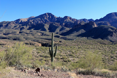
There were nice views of the Canyon Lake and Four Peaks. The air was unusually clear.

After wandering around for a while I made it down to the creekbed below the waterfall. It isn't difficult if you know where to go, but I didn't so it took a little while.


On my way to the creekbed, I found this large tinaja. I was about 20 feet above it when I took this.


There is a very narrow slot hiding the waterfall.

There's a narrow slot that curves and blocks the view of the waterfall from downstream. I couldn't figure out how to take a picture that would show what the location of the waterfall looks like, so I made a short video. I had the camera zoomed all the way out but you still get the feeling you can't see anything. I guess that's because everything is so close.


There was quite a drop from the creekbed I was in to the tinaja I had spotted earlier, so I started looking for the next potential waterfall. I couldn't see it from the creekbed, and I couldn't see a way down that I could get to before sunset, so I tried to find a view of it from the other bank of the creek. This is what I found.


I made a video because, once again, I couldn't figure out how to take a good picture of it. Well, I guess I could have gone there at the right time of day and used some ropes, but I'm not that dedicated. I did take some pictures, though.


Best picture I could get of the arch on this day.

I decided that I would wait until I got some better pictures of the arch before I wrote a blog about it. I took a Friday off and got back out there with plenty of sunlight. As I was looking for the path I had chosen from looking at Google Earth, I stood on a small hump of rock. I decided where to go and as I stepped down from the rock, I slipped. I was reminded of a statistic I had read, that one third of adults 65 and older fall every year. I'm still a few years away from 65 but I probably fall 2 or 3 times a year. I hope that means that I'm doing things that most 65 year olds don't do and not that I have the physique of a 70 or 80 year old. I didn't fall this time, but the palo verde I leaned on extracted a price from my skin for its support. Also, I don't know how I did it, but I got quite a cramp in my right tricep. Must have done that whirling my arm around for balance. Too bad I don't have a video of that. Anyway, I knew from looking around while I was out there before that getting to the bottom of the arch without ropes might be difficult. There was a lot of vegetation in the way. I brought along some pruning shears in case I needed them. It turns out they were useless. I would have been cutting all day. I don't think I've ever come across such dense vegetation in the desert. Yes, it is worse than Pinto Creek. Even if most of the plants didn't have thorns, I don't think it would have been possible to push through it. You would just bounce off. I found a way around the side of all those plants, though. It was steeper than I liked but even if I fell, I don't think I could have hit the ground. That reminds me of something Tim or Tom said (I forget which). They were talking about hunting geese and got to arguing about which one of them is a better shot (they're twins). One of them said to the other, "You couldn't hit sand if you fell off a camel." Maybe it's an old joke, but it's up there with the top 10 funniest things I've every heard.

Anyway, back to the arch. So I found a way around all the plants, only to find myself at the next obstacle. I knew this one might be a showstopper, too. That large tinaja I had seen on the first hike blocked my path. Even if I did wade across it, I could not have climbed up the slick rock on the other side.


Curses, foiled again.


This is the closest I could get to the arch. There were better views further away, but no good views.


The view from much further away.

I was looking at the area on Google Earth and thought there might be some more interesting stuff in other places out there so I decided to put off the blog a little longer. Sunday was another remarkably clear day and I went along the First Water Creek overlook trail looking for a way to go north from the trail.


Do you know who sang "On a Clear Day, You Can See Forever"? I must have heard that song about 50 times during the summer of 1970.

I followed the trail all the way to the waterfall at the end. You are at the top of the waterfall, though, so you can't see it. It's a 90 foot drop there, straight down. It's one of those things I can't take a picture of, so here's a video. I got the name of the trail jumbled at first but I corrected myself. Does anybody else remember when Frank Reynolds was discussing the sequence of events during a shuttle launch in the '80's and he said something about the "solid rooket bosters"? He got a funny look on his face like he suspected something was wrong but he wasn't sure what, and then decided to carry on with what he was saying without thinking about it any more.


You will notice some strange distortions during the video. That's because I made the video with my cell phone camera and I didn't know it had image stabilization so I didn't turn it on so it was really shaky so I let YouTube smooth it out. Well, my videos are pretty shaky even with image stabilization. Anyway, I think it's a pretty good video for a cell phone camera. It's a new phone and I'm still learning what all the camera can do.

Anyway, to digress from my digression, I've always thought it would be cool to get pictures of that waterfall from down in First Water Creek. That's why I keep trying to find ways down to it. It's easy to get to the creek by following Black Canyon down, but it isn't possible (at least for me) to get to the waterfall location from there.


It's easy to get down to that part of First water Creek.

So now I was thinking about how to get to that stretch of First Water Creek. I decided to put off the blog until I tried another route down to First Water Creek. It was an after-work hike, so it was almost dark by the time I started. There's a path I had been meaning to check out for a year or two that I finally explored. It seems to be a dead end. Or maybe I couldn't see where it went in the dark. It seemed to just end at a cliff. Since it was so dark and I was trying to hurry, I didn't get any interesting or even informative pictures.

I was messing around with the GPS tracks for the last 3 hikes and noticed that they kind of encircled an area, with a big unexplored spot in the middle. I decided that I needed to put off the blog until I checked out that area.

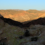
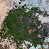
It was another after work hike. It had rained that morning and the moss on the rocks was a beautiful green. I didn't see anything more amazing than the usual beautiful scenery (which was too dark to photograph). But now I feel like my exploration of that area is complete. The problem with waiting so long to write the blog, though, is that I have probably forgotten to mention something interesting that I came across during those hikes, like the tarantulas or the area that smelled like a large dead animal or the hiker that was carrying a hammer. Hmm. He was near that dead animal smell. I wonder if there could be a connection. Anyway, there are several batches of pictures below.

2013_10_01

2013_10_04

2013_10_06

2013_10_08

2013_10_10

Sunday, September 15, 2013

Along and around A Cross Road

I went for a drive along A Cross Road and some roads that intersect it yesterday. I was planning to hike some, but my stomach decided that wasn't a good idea. So I just drove around getting pictures of the awesome clouds and some other desert stuff.


I like the way this turned out.

Along FR-88 I saw three saguaros with tires on them. In Texas the kids go cow tipping. I guess in Arizona they go saguaro tiring.


A "tired" saguaro.


Along NF-88.


I think this is my favorite.

Nothing exciting happened. No disasters. Nothing to write about. Click below for all of the pictures.

2013_09_14