Sunday, October 31, 2010

Further into the Goldfield Mountains

It looked like the weather was going to be nice on Saturday. All week long I had been thinking about going further into the Goldfield Mountains. I used Google Earth to pick a destination.


My destination. Of course, this picture isn't in Google Earth yet.

A few months ago, a guy in Apache Junction (Dave) had contacted me about one of my EveryTrail trips (on the Carney Springs trail). Earlier in the week he asked about going on a hike with me some time. He joined me on Saturday. I tried not to slow him down too much.


Dave enjoying the view.

The view was very nice from the top of the rock at the far end of the hike. Several times while we were out there, we heard what sounded like thunder. The sky was blue all around; I don't think it was possible for it to be thunder. It didn't sound like explosions. I have no idea what it was.


The view from the rock at the far end of the hike.


Saguaros.

While planning the hike, I was thinking that I might take a loop around at the far end. While looking down at the wash I thought I would follow for part of that loop, I could see that it was full of paloverdes and catclaw. I didn't want to push through that for a quarter mile. Also, it was getting close to sunset, so it would be wise to take a known route back. That's what we did.


I took a lot of pictures of the Superstition Mountains on this hike.

I think we only hiked about 4 miles, but I was tired. I'm not sure how I'm going to go further into those mountains. I may have to make some 2 day hikes. Click below to see all of the pictures.

BC_2010_10_30

Saturday, October 30, 2010

Yet another panorama of the Superstition Mountains

Sweetums and I were going to go for a ride through Bulldog Canyon yesterday but she had to cancel at the last minute. I decided to go anyway and climb a small hill to check out the view. I couldn't get the lock open, though. The locks at the Wolverine Pass entrance and at the Packsaddle road entrance are often abused. It was getting close to sunset, so I just drove around a little and then decided to make a panorama of the Superstition Mountains from the intersection of Idaho road and McKellips.

Sunday, October 24, 2010

Wandering around in the desert

I had plans to go further into the Goldfield Mountains on Saturday. I wasn't feeling very energetic, though, so by the time I got out there I changed plans. First I had to decide where to start. That was easy. I started where I found a place to park. Then I started walking in a direction that it seemed unlikely that most people would go. Several people had been out there, though. I saw a very old can, a gun shell, and several mining claim markers.


I started out going in this direction.


There were some nice fluffy clouds around.


I eventually decided to hike up to the top of that cliff on the left.


A mining claim marker. When I came across this, I felt obligated to empty my pockets of all the gold nuggets I had collected so far. That's OK; they were pulling my pants down.

I kind of headed uphill, then cut over to another ridge and headed uphill, and kept doing that until I noticed I was getting close to a cliff. It looked like it would be easy to get to the top of the cliff, and the view was bound to be great from up there. To the cliff, then.


Almost to the cliff (that's it on the left). I took a lot of pictures of the Superstition Mountains on this hike.

There were large animals out there, too. I got close to two of them but never saw them. The first one was in a dense stand of paloverdes. I could hear it walking away. Sounded like a deer. The second one was near where I started walking out onto the cliff. I was slowly walking up to the ridge, snapping pictures along the way, when I heard what sounded like something sliding and then a lot of rocks tumbling. I quietly peeked over the ridge but whatever it was, it was long gone.


That's the top of the cliff on the right.


Not zoomed in on the Superstitions. They look so small.


Panorama of Gold Canyon and Apache Junction.

As I was standing on the cliff, I decided to take a picture of the Superstitions with my phone and send it too a few people. As I was doing that I noticed that there was an update for the Droid EveryTrail app. I downloaded it and decided to use it to make a trip out of my hike back to the truck. One reason I wanted to do that was to see how it handled loss of cell phone service. I was sure that would happen as I descended. It didn't, though. Even though no bars were showing, the map kept getting updated (the map isn't stored in the phone). I'll have to try that experiment again someplace else. The app looks much more sophisticated than it did the first time I tried it out. It seemed to work flawlessly, too. I used the phone camera for the pictures in this trip, so they aren't too hot.

Bulldog Canyon Experiment


EveryTrail - Find the best Hiking near Mesa, Arizona

Click below to see all of the pictures.

BC_2010_10_23

Monday, October 18, 2010

I made it

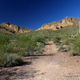
Last weekend I was exploring for a route to some pinnacles at the base of the Superstition Mountains, and thought I had found a good one. On Sunday morning, though, I was looking at Google Earth and saw what looked like an old road going almost straight to where I wanted to go. Beyond the end of the road I could see a faint trail. It looked like the trail ended at a wash, but I didn't think it really did. I was pretty sure it would continue. Maybe some rock climbers had a trail marked out all the way to the pinnacles. Walking along an old road and a trail would be easier and quicker than stepping around a bunch of brittle bushes, so I changed plans.


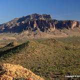
My goal seems far away and high above me.

The old road enabled me to move very quickly toward my destination. In fact, I was walking so fast I missed a lot of things. I saw them on the way back, or hints of them, but it was too dark for pictures by then.


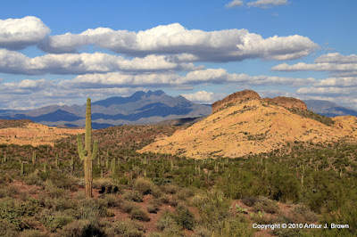
The sky was a mixture of pretty and ugly clouds.


One cool thing about being up high is seeing all the other places I've been.

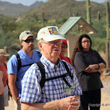
I could tell that I was approaching the end of the wide part of the trail when I encountered a couple coming the other way. I asked them where the trail went and they said that in about 10 minutes I would come to a lot of boulders that I would have to climb over. That's where they had turned around. I didn't want to climb over boulders, so I was hopeful that I would find a way around.


The couple I encountered is in the lower left corner of this picture. I didn't mean to get them in the picture, so that's why they are hard to see.

A couple of minutes later the trail became a narrow foot path that twisted this way and that. It was marked with cairns along this part. It's the kind of trail that is easy to loose if you don't keep looking to your left and right. I think that must be what happened to that couple. They thought they were following the trail but ended up in the bed of a wash. I never encountered any boulders that I had to scramble over.


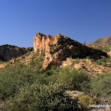
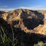
This lovely arrangement is very close to the pinnacles.

I was elated when I stepped on the the bare rock that forms the base of the pinnacles, but not so elated that I forgot to take careful note of where I was, so I would be able to find the easy way back. I spent about 45 minutes wandering around up there taking in the sights and taking pictures.
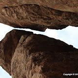

One of the sights.

I hung out there long enough that I knew it would be dark before I got back to the truck. I just wanted to make it to the straight part of the trail before it got dark, and I did that with no problem. It was a much longer hike than I've been on for a few months, so I welcomed the chance to stop and take sunset pictures on the way back.


I spent 2 or 3 days wandering around out there looking for a route to those pinnacles, then on the day I hiked all the way too them, I took a route I found looking at Google Earth. Well, I had fun wandering around those 2 or 3 days, so that wasn't wasted effort. In fact, my primary objective on those days was to wander around in the desert. Finding a route was secondary. You never know what you'll come across just wandering around off the beaten trail. Click below to see all of the pictures.

2010_10_17

P.S. I've had my SPOT satellite messenger for a year and 10 or 11 months. I finally had to change the batteries. That's pretty amazing for a GPS receiver that also transmits my position to an LEO satellite 3 times every ten minutes.

Saturday, October 16, 2010

Spur Cross Ranch Conservation Area

There was an article in the paper last week about a retired teacher who leads geology hikes in the Spur Cross Ranch Conservation Area once a month. I wanted to learn something about rocks, so this morning I went on that hike.


Tom McGuire, our guide for the hike.

The hike started at 9, and I quickly remembered why I don't like to go hiking in the morning. There's something distressing about hiking in the heat when it keeps getting hotter. It wasn't real hot, though. It probably didn't even get up to 90 before we finished the hike 2 hours later. The air was very still, though.


Elephant Mountain. I took half of my pictures before the hike even started.


There are some nice mountains in the area, but it was the wrong time of day to be getting pictures of them.

I didn't take a lot of pictures on the hike because the sun was too high and because every time I saw I picture I wanted to take, there was somebody standing in it. There were about 100 people on that hike. Some looked like they were accustomed to hiking in the desert and some looked like this might be their first time off the pavement. A lot of them had wooden hiking sticks. I carry one, too, if I'm going on a long or steep hike. Didn't need one today. This wasn't a comfortable hike for me, though. It was mostly level and we moved slowly. Kind of like ambling through a shopping mall with a window shopper, which makes my hips hurt for some reason. The last few hundred feet back to the parking lot were uphill. Oh, that felt good!

Tom is a good speaker and is very knowledgeable. He would stop to talk about something every now and then. In between stops people would ask him questions and I tried to walk close by to listen in. Consequently, I was usually in the middle of the crowd. Not a good place to be for getting pictures. Anyway, click below to see all of them (pictures, that is).

2010_10_16

Tuesday, October 12, 2010

Finding a route

A few weeks ago, I had gone on a hike trying to find a route to the old Massacre Grounds trailhead. I didn't quite get to it, but I was worn out anyway. Well, yesterday I was looking at Google Earth and decided to try going it that direction again, only this time I would follow a large wash. My destination had changed, too. I wanted to get to some hoodoos that are in that direction.


This looks interesting from far, far away, so I want to get a closer look.

The sun sets so early these days I knew I wouldn't have time to get all the way out there. I just wanted to see if using the wash to go that direction would be workable. I quickly learned that being in the wash was a bad idea. Lots of boulders to step over and lots of loose sand to sap speed and energy.


This is not a preferred place to hike.

I stayed in the wash for a while, though, because there were lots of footprints there. Maybe they knew something. I think maybe they didn't. There were getting to be a lot of trees in the way so I got up on the left bank of the wash. Wow, it got a LOT easier to walk. There were a lot of teddy bear chollas in places so I had to be careful where I put my feet, but I didn't have to worry about twisting an ankle.


My favorite variety of cholla, despite all the pain it's inflicted.

I made pretty good time on the way out and wasn't too worn out by the time I had to turn around. On the way back, I learned that I should follow the right bank at first, then switch to the left after a quarter mile or so. It was a successful outing. I learned what I wanted to know.


I think most of the saguaros in this area were wiped out by a fire many years ago. There are black brittlebush stubs all over the place.

It was getting pretty dark on the way back. I figured the rattlers were probably coming out and looking for a meal. The last half mile or so made me a little nervous but I didn't see or hear any snakes. It's a good thing, too, because the internal flash on my camera refuses to pop up. For some reason it thinks an external flash is attached. I wonder if I messed up some setting somewhere. Gotta figure that out.


Got a picture of the moon.

Remember how I used to put hikes on EveryTrail? I started using EveryTrail because it was so easy to transfer pictures from a web album to an EveryTrail hike. A few weeks ago, that function broke. I mentioned that in my previous blog. The very next day, I got a message from Joost. I think he is one of the two guys that started and runs EveryTrail. You know, I gripe about Microsoft all the time, but Bill has never sent me an email asking what he can do to help. Anyway, when I got my jaw off the floor, I sent info on the issue to Joost. It turns out that Chris (the other EveryTrail guy) had responded to my issue on an EveryTrail forum; I thought I would get an email when somebody responded but either I didn't or I missed it. Anyway, the problem seems to be on the Picasa end so there probably isn't much the EveryTrail team can do about it. Well, they may have some connections at Google. Anyway, I'll try it now and then to see if it's fixed. It might already be fixed. I haven't tried it for 2 or 3 weeks. I'm also going to see if I have some software that will resize pictures for upload in batch mode. (I'm an engineer. I'd rather spend 2 hours writing a program to do something than 15 minutes doing it by hand.) I'll let you know what happens. Well, you knew that. Click below to see all of the pictures.

2010_10_11

Sunday, October 10, 2010

Back in July, I had come across a faint trail in the Goldfield Mountains. I ran out of light and water before I got to the saddle the trail seemed to be headed toward. I went back to that trail on Saturday.


My destination is up there.

It was in the mid 80's; very pleasant. There weren't many people in that part of the OHV area, either. I just saw 2 guys in some sort of dune buggy thing roar by in the distance. Once I went over the saddle, I think I pretty much had the place to my self. Just me, quail, cactus wrens, and crickets. Strangely, no buzzards circled me on this hike. Maybe I looked a little too lively.

The trail seemed more clearly marked than before. I don't remember so many cairns. Some that I had seen before were gone, though. Maybe blown over during storms. I wonder who made the cairns, and why they went to all that effort. In places the trail is hard to see, but in other places it looks like hundreds of footsteps have passed over it.


This was dry last July.


The saddle is just up there.


Dome Mountain.

It's a climb of only about 500 feet. There are a few short steep parts, but they aren't bad. I covered 3 miles in 2 hours and 42 minutes. That includes time spent enjoying the view. Two hours and 17 minutes of moving time. Hmm, that makes my average speed below 2 mph. And people always complain about me walking too fast. Ha.


The view on the other side of the saddle; a sight few people have seen.

I didn't realize I was right next to Dome Mountain until I got home and was looking at a map. I didn't take many pictures in that direction because it was to the west (and it was afternoon). I wondered if the cairns might be marking a trail to Dome Mountain, but I didn't see any more of them once I got to the saddle. No trace of a trail towards Dome Mountain, either. Maybe I'll find a route up there this winter. I've kinda wanted to go up there for years, but didn't think there was a route without real climbing. Maybe there is, after all.


This looks much prettier when you are standing there. Maybe I just don't know how to get a good picture of it. Or maybe one thing that makes it so pretty is being there, away from the turmoil in town, and looking at the picture at home while lazy kids are doing things that give me heartburn has removed its most enchanting aspect.

I took pictures thinking I would put together a panorama of the view from the saddle. It looks to me like there is plenty of overlap in the pictures, but ICE couldn't figure out how they go together.

I'd like to put this hike on EveryTrail, but I haven't been able to upload pictures to my hikes there for a few months. Something is broken, but nobody else seems to be complaining. I've tried 2 computers and 3 different browsers. I'm trying to upload from my web album. Maybe the web album has more albums than their software can handle ("Nobody will ever have more than 512 web albums!"). Who knows? Click below to see all of the pictures.

2010_10_09

Wednesday, October 06, 2010

Stormy weather

We've been having some exciting weather around here lately. There was a storm on Saturday with lots of wind and dust. There was just enough rain at my house to make the dust stick to my truck. Then we had storms most of the day yesterday. The last one to come through, around 8:30 or 9, had lots of wind and hail. We got a decent amount of rain, too.


In the desert, we water our grass whether it needs it or not, and I don't believe this grass needs any more water.

I went driving thinking that I might get some pictures of storms or rainbows. By the time I got out to the Superstition Mountains, it looked like the rain had stopped. I stopped on the side of Apache Trail and took a few pictures.


I like the way this turned out.

I went into Bulldog Canyon OHV area over there and drove to the top of a hill to see if I could get some sunset pictures. The sun was gone by the time I got there.


It smelled wonderful out there. I love the smell of creosote bushes after a rainstorm.


I hung around out there until is was getting dark. As I drove back to the gate, I realized I didn't have a flashlight. They were all in my backpack, at home in the bedroom. The lock can only be seen from the outside, so my headlights wouldn't do any good. Then I remembered the flashlight app for the Droid, and remembered further that I didn't download it because I thought it was a silly app. Who's silly now?


I had no signal. Couldn't download it. I hoped that I would have a little signal by the time I got to the gate. Just a few hundred feet later, I got a text from my Sweetums. A signal! I downloaded the app and had no trouble getting the gate open.

I was in a store last week and wanted to know the price of something for which the price label had been removed from the shelf. I downloaded the barcode scanner app and looked it up. This Droid is pretty handy. Kinda reminds me of Trinity on The Matrix when she needed to know how to fly a helicopter. Click below to see all of the pictures.

BC_2010_10_05

Sunday, October 03, 2010

A couple more Photosynths

It was still a little warm on Saturday so I didn't want to go on a long hike. I decided to go up to the top of Coronado Mesa and take pictures for a Photosynth of the canyon to the north. I was going to try something different, too. I took HDRIs and tweaked the contrast before stitching them together. I didn't zoom in a lot. I didn't want a lot of detail. I just wanted to get a picture that showed the view.


Click below to see the rest of the pictures.

2010_10_02