
My destination. Of course, this picture isn't in Google Earth yet.
A few months ago, a guy in Apache Junction (Dave) had contacted me about one of my EveryTrail trips (on the Carney Springs trail). Earlier in the week he asked about going on a hike with me some time. He joined me on Saturday. I tried not to slow him down too much.

Dave enjoying the view.
The view was very nice from the top of the rock at the far end of the hike. Several times while we were out there, we heard what sounded like thunder. The sky was blue all around; I don't think it was possible for it to be thunder. It didn't sound like explosions. I have no idea what it was.

The view from the rock at the far end of the hike.

Saguaros.
While planning the hike, I was thinking that I might take a loop around at the far end. While looking down at the wash I thought I would follow for part of that loop, I could see that it was full of paloverdes and catclaw. I didn't want to push through that for a quarter mile. Also, it was getting close to sunset, so it would be wise to take a known route back. That's what we did.

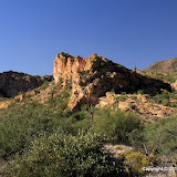
I took a lot of pictures of the Superstition Mountains on this hike.
I think we only hiked about 4 miles, but I was tired. I'm not sure how I'm going to go further into those mountains. I may have to make some 2 day hikes. Click below to see all of the pictures.
 |
| BC_2010_10_30 |


No comments:
Post a Comment