Hiking in the Sonoran desert, with photographs of saguaros, lizards, birds, scorpions, flowers, other desert flora and fauna, mountains, rocks, sunsets, etc.
Remember how gloomy it was last Saturday? There isn't any rain in the forecast until Monday, so I wasn't worried about rain yesterday. We had the exact same pattern of clouds moving in from the southwest, though, and by the time I got out to Bulldog Canyon, the sky was grey.
The Supes on a gloomy day.
I didn't want to drive a long way on Saturday, so I headed for Bulldog Canyon. As I approached the Wolverine Pass entrance, I remembered the guy that didn't have a pass the last time I was out there and all the knuckleheads that break the lock and tear up the desert in that area and thought about going someplace else. I had about decided to turn around when I saw a ranger at the gate. He was checking passes as people entered. Hallelujah. It was good to see them doing something about the knuckleheads.
I'm going to walk up there somewhere.
The people that had passes and got in still drove places they weren't supposed to, but I won't get into that now.
I planned to go somewhere I hadn't exactly been before, just to see something slightly new. I headed up the side of a mountain. Part way up, I thought I could see a wall built near the top. I zoomed in and took a picture, and zoomed in on that and decided that maybe it wasn't a wall, but decided to wander in that direction until it got impossible or I got tired.
Does that look like a wall to you?
I kept thinking I should stop and turn back, and then I would think about looking at the pictures when I got home and realizing that it was a wall and I needed to go back up there to check it out, so I kept going. Eventually, I got to a point where it was getting dangerously steep. When I'm putting my hands on the rock as I'm climbing up, it's too steep. Fortunately, I have decided that it's just rock and not a wall.
On the way down, I saw an air rescue helicopter fly over. I think it had come from somewhere in the Superstition Wilderness. I wonder if a hiker ran into trouble out there. I guess it could have come from the twisty road by Canyon Lake, too.
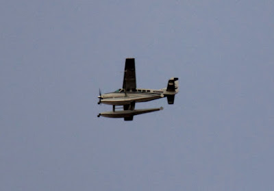
I also saw a plane with pontoons. You don't see those very often in Arizona.
Your landing options are somewhat limited in Arizona with this plane.
While taking photo point pictures near Roosevelt Lake, I had seen several things I wanted to check out further when time and weather permitted. It wasn't supposed to be raining on Saturday (it's strange how often I have to take that into consideration in a desert during a drought), so I went out there to look at a small canyon formed by Parker Creek. I did get sprinkled on a couple of times out there, but it wasn't enough rain to get anything wet. It was overcast and gloomy, though.
Parker Creek. Barely visible in the background is the scenic and more popular Parker Canyon.
The first thing I found when I got down to Parker Creek was a gold pan.
At first it looked like Parker Creek was dry. That's because it had gone underground. When I got to the narrow part of the canyon, which has a solid rock bottom, there was flowing water. That was also when the weather started to bother me. It was so gloomy. I was surrounded by grey rock with a grey sky overhead. It was also eerily quiet. I like the quiet of the desert, but it was just too quiet. There wasn't even a hint of a breeze. Near the water, you could hear it trickling over rocks, but that was the only sound. As gloomy as it looked, I wasn't very interested in taking pictures. Since the light wasn't good for pictures, I didn't want to go to the effort of clambering upstream very far.
Gloomy canyon.
A short video with the sound of the water.
There was another thing that I wanted to check out in that area. Northeast of the A-Cross ranger station (which is now closed and boarded up), there's a clump of green on the side of a large hill (must be a spring there). If you look at the area on Google Earth, it looks like there are two large, white rectangles in the middle of the green. I wanted to know what those what rectangles are.
As I drove back to A-Cross road, I noticed a small room built into the side of a hill. I had seen a larger one a little south of this one. A ranger tells me that structures like this were probably used to store explosives used to build A-Cross road. The crew working on the road was housed on the other side of the hill, safely away from the explosives. Something unusual about these two structures is the concrete roofs. Usually, the roof would be made of something flimsy so all the force of an explosion would go up, without launching rock missiles.
Explosives storage.
From the top of the hill with the explosives storage rooms, I could see a structure of some sort in the middle of the trees on the side of the hill northeast of the old ranger station. I was getting really curious about what it was.
The (closed) A-Cross ranger station, and something on a hill.
The road to the ranger station is closed, also, but I was able to get reasonably close. For most of the way up the hill, I couldn't see what I was looking for and just had to go in the direction I thought I should. That usually works pretty good, though. I came across a couple of low walls along the way. They must have been built in an attempt to control erosion.
A low wall on the side of the hill.
I didn't approach the spring from the best angle. I struggled through dense vegetation and a pile of plant debris to get to it. There's a fence around the area and the plant debris came from clearing out the fenced area.
My first view of the structure. A fence inside a fence? And how could this show up on Google Earth?
I could see a gate and worked my way over to it. There was a sign there that said, "BAR ELEVEN RANCH WATER SOURCE KEEP OUT". OK, I know what it is, but I still don't know what the big white rectangles are. I figured the "keep out" part was meant for people that might mess with their water and went in, being very careful not to mess with anything. I would have gone around the outside to see what was in there if it hadn't been nearly impossible to move through the dense foliage outside the fence. Anyway, the white rectangles are the cement lids over large tanks that capture spring water. Mystery solved. The fence at the back is to keep dirt from washing down and covering the tanks.
The white rectangles.
Turns out that there's a trail going up to the water tanks. I followed it on the way down. It was much easier than the trip up there. It was getting dark by the time I got to the truck.
As you enter Bulldog Canyon OHV area at the Wolverine Pass entrance (see the link to my map of Bulldog Canyon to the right if you're interested in knowing where that is), there's a low rock cliff on your right. I've been driving by that cliff for years and thinking that someday I was going to walk along the top of it. On Saturday, I headed for Bulldog Canyon planning to go someplace other than that cliff, but you know how I am.
The low rock cliffs.
There was some guy with some dirt bikes on a trailer hanging around the entrance. I had a feeling he was looking for somebody to open the gate for him. I decided that it was time to walk along that cliff and parked in the lot at the entrance. I was loading up when the guy came over with a sad story about getting to the ranger station just a couple of minutes too late to get a pass on Friday. There sure are a lot of people that are willing for me to incur fines and lose my pass on their behalf. He seemed like a nice guy, but I'm not going to take on risk for no possible benefit to help some stranger skirt the law.
He hung out there for a long time hoping to get in. An hour later some knuckleheads left the gate open, but this guy was gone by then.
The Wolverine Pass entrance is the entrance that's closest to town. Consequently, it's the most popular with knuckleheads. One road leaves the gate and splits into two, but the knuckleheads have made trails criss-crossing all over the place in that area. Before long, there's going to be nothing but bare dirt hills there. Anyway, I followed a trail made by dirt bikes towards the cliff.
The trail I followed is on the right side of this picture and goes through that shadow.
It was an easy hike to the top of the ridge, and there were nice views of the Superstition Mountains and Goldfield Mountains from up there. It would probably be a good place to get pictures of the city lights at night, too. There were fresh shod horse (i.e. not wild horse) prints along the top. Maybe people ride out there when they rent horses along Apache Trail.
Rocky view.
A view of the Superstition Mountains.
The scenery is nice in that area, but for the last hour I had to listen to the constant buzz buzz buzz of dirt bikes tearing up the desert. That's why I don't hike near the entrances very often.
I've been having a little trouble making blog updates lately. I've been distracted by an irresistibly cute 2-year-old. If she wants to play, I can't say no.
I knocked off two sets of photo points on Sunday. It's the ones that I didn't do a few weeks ago because I had forgotten to take the notebook with me. Park Creek was very easy. Just two photo points, not very far apart, and it didn't take me long to find them. I had looked at the location of the Reno Creek photo points in Google Earth and based on that and the reference photos, I thought it would be even easier than Park Creek. Silly me. I should know better than to think that.
It was easy to find the general area of the Reno Creek photo points, and they are all pretty close together. Two things threw me off, though. First, the reference photos had been taken after a fire that had cleared out a lot of vegetation. The plants have made a roaring comeback and visibility was severely shortened since 2006. Second, the hand-drawn map of the area doesn't quite match what is there. Maybe there are minor errors, or maybe the fence has been moved around a little. Anyway, I couldn't get to where I thought the first photo point should be. I finally decided to see if my phone had a signal and I had a 3G signal, so I opened up Google Earth and went to my location. I wasn't where I thought I was. No big surprise. I walked to where I thought I should be and then I was further from where I was supposed to be. Wow, it sure was handy having Google Earth with me as I wandered around. I decided to walk the perimeter of the fenced area and try to match the track on my PN-40 to the drawing in the notebook. The shape I got was sort of a mirror image of what was drawn. I think that was what caused a lot of my confusion. Now I was able to go directly to the first photo point. Well, almost. There are several very large sycamore trees out there. One of them had fallen on the first photo point. I got as close as I could to the correct spot. A tree in the reference photo that convinced me I was in the right spot is almost hidden now because of all the new growth out there.
After getting myself oriented and getting the first picture, I relaxed and sat down to have a snack. Remember when I was at another photo point location a few weeks ago and there were lots of birds and I knew there were some woodpeckers but all I saw of them was quick streaks as they flitted back and forth? Well, anyway, they were at Reno Creek, too. While I was eating, one landed on a narrow branch almost directly overhead and stayed there long enough for me to get a picture.
A Gilded Flicker, directly overhead. I'm glad there weren't any clouds up there or I wouldn't have gotten a decent exposure before it flew off.
The rest of the photo points went smoothly (except for the occasional fallen tree blocking a view). When I had been looking at maps before I went out there, I had seen that there was something called "Camp Reno" near there. Turns out there's a sign marking the general area. I decided to see if there were any ruins.
Camp Reno, occupied from 1868 to 1870.
As I was walking to the truck to leave the notebook there, I came across a couple of guys that asked me if I knew where Camp Reno was. I explained that I was just going to look for it. One of them shook his head and said, "Good luck". I guess they had been looking for it for a while themselves. Anyway, I was heading into the woods (it was kind of woodsy) when they drove by on their way out. They asked if I needed some water or a snack before they left. That was very kind of them. I told them thanks, but I have plenty. Afterwards, I got to thinking that their offer was just a little odd. If somebody was hungry or thirsty, they wouldn't be wandering off into the desert in search of a long-abandoned camp, would they? I thought a little more and realized that isn't the first time something like that has happened. On a couple of occasions, I've come across other people who looked concerned and asked if I was OK and if I needed anything. I wonder if it's the grey hair or if I just look much worse than I feel when I'm hiking. I'll have to try to get some pictures.
I didn't see any structures, or anyplace that looked like there used to be structures. There is an "Old Fort Reno" marker on the PN-40, so I stood in that exact spot and took a 360 degree panorama. Maybe you can find something in the picture. I couldn't.
Old Fort Reno. Well, its location.
Most of the 300 or so pictures I took that day went into the photo point pictures. Click below to see the rest.