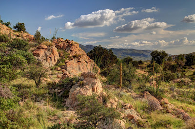
Fortunately, there was lots of shade.
I started the hike around noon, and I think the temperature was around 100. It's still the wet season, too, so it was a little muggy. The entire hike was in the bed of Silver Creek, which was mostly dry. It had rained recently, though, so the sand was packed pretty good. Made walking a little easier. I walked lightly so as not to break through the sand because that just saps your energy, but so does walking lightly.

These flowers were all over the place. I haven't looked them up in my plant book yet, though.
Shortly after starting the hike, I stepped on what looked like "solid" sand but sank about 3 or 4 inches with no resistance. At first I thought of quicksand, but it wasn't quite like quicksand I've been in before. The surface was too loose and it was easy to pull my foot out. I didn't want to test it any further, though. I stepped in stuff like that a few times, which kept my boots wet.

Bear tracks.

More bear tracks.
I came across bear tracks about half a mile into the hike. Amazingly, I happened to have effective bear protection with me. It would be a last resort, though. I would really have liked to get some pictures of a bear, but I made lots of noise for the rest of the hike. I heard noise in the distance every now and then that might have been a bear or a deer moving away. I saw tracks of both but never the animals.
I was looking for a fence that marks the location of the photo point. I went past the coordinates given on my treasure map, then past the National Forest boundary shown on my GPS receiver map before I found a fence. About all of it that was still standing was the gate.

Found it.
I got the pictures and relaxed for a little while before heading back. It was hot. Really hot. I drank over 2 liters of water in 3 hours. You've got to eat something when you drink (and sweat) that much or your electrolytes get wacky. Amazingly, I was not out of snacks. Having everything I needed made for a pleasant hike despite the heat. I should be prepared more often.
When I got back to the truck I decided to drive up to Bishop Creek. I had been looking at pictures the night before and it looked like I had missed a photo point there. It had rained a few times since the last time I was out there. The road was in much worse shape. It seemed steeper, rougher, more rutted, and there were a few mud holes. I was almost to the creek when I came to a bad spot in the road that I didn't remember at all. One side had a 2 foot drop and the other was tilted at a severe angle. I couldn't drive over the drop and the tilted side looked scary. I decided to go back up the road a few feet where it was wide enough for me to park and hike to the creek. I was on what seemed to be almost level sand. I could barely back up. When I got to solid ground, the back tires kept sliding into ruts that I could not get out of. It looked like there might be enough room to turn around and hit the solid ground going forward, but when I turned the wheel the truck would not move. It just dug in. I was getting ready to push the "I'm OK but I'm stuck" button on my SPOT and hope that Skid would see it and come to my rescue. I decided to try going over the tilted part of the road first, though. If I'm going to be stuck, I might as well be really stuck. It was exciting but all of the tires stayed on the road. Now I was on another mostly level sandy spot. I had backed into a parking spot there before. I tried it again. I could not back up. I was upset. There was a one foot drop in front of me to Bishop Creek with lots of room to turn around, if I didn't get stuck in the sand there. There was also a slight slope to the creek to my left, so I went that way and made it down without bottoming out. I kept moving as fast as I could, afraid I would sink if I slowed down. I got turned around and aimed for my exit from the creek bed. It was bumpy but no problem. I kept my speed as high as I could and aimed for the precariously tilted road. It was bumpy but I made it up easily. I aimed for the only path ahead that wouldn't have my tires stuck in a rut and was going as fast as I dared. I made it up that and slacked off since I was on previously traveled road. My heart was pounding. I parked in the wide spot and was gathering my gear to get the missing pictures when I remembered that I had miss-numbered some photo points on my GPS receiver. Number 5 was not missing. I remembered seeing the windmill there in my pictures. Wow, all this for nothing. I backed back onto the road, put it in drive, and the tires spun. I began to wonder if there were gravel fairies throwing marbles under my tires. I locked the axle and slowly accelerated. Once I was moving, I didn't want to slow down again. That's when I accidentally veered off on where the road used to go. I hoped the "road" I was on would join up with the main road soon, but I didn't get far before I had to back slowly to the main road again. I put it in drive and the tires spun. I backed up a couple more feet and was able to get moving forward. The rest of the drive up that slope was made just slow enough to keep from bottoming the suspension. All this made me think seriously about getting a 4wd truck. The problem with getting a new truck is that I wouldn't want to take it on roads like that because branches might scratch the paint. Still, worrying about paint is probably better than wondering if I could possibly get home in time to go to work the next day. I don't like staying up past my bed time or skipping dinner.
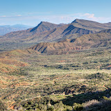
I had been looking at a terrain map of that area a few weeks ago and noticed that there was a huge valley just east of where I had been taking pictures. I drove out there to take a look. It was spectacular. Or maybe it just looked spectacular because I wasn't stuck in Bishop Creek.

A little bit of the view. Four Peaks is on the horizon.

The view looking east. The Verde River is down there.
Click below to see all of the pictures.
 |
| 2012_08_26 |