
Thursday, December 31, 2009
The sun does shine
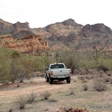
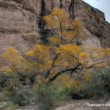
It isn't always cloudy here. Suzanne and I drove out to Canyon Lake this morning and I took a picture to show that we do get some sunshine now and then. It may be cloudy again tomorrow, though.
Wednesday, December 30, 2009
Curses, foiled yet again
I left the house before noon today. I took food. I took lots of water. I had a sweatshirt with me. I was prepared to go to the top of the Goldfield Mountains. It turns out that I still don't know how to get there, though.
It was another gloomy day. There sure have been a lot of those lately. I don't like the way the pictures look. There's a lot of them, too. I tried taking at least one picture every 100 paces or so. I didn't stick to that when I was struggling through washes, though.
A few days ago (maybe it was 2), I identified a canyon as the one I was going to try to hike up to get to the top of the mountains. Turns out I was wrong. You can't really see into the canyon I used because it curves. I didn't even get to the curve, though.
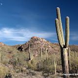
The beginning of that canyon has very steep sides. I don't know if I could walk on them, but I do know that I will not try. Too steep, too dangerous. So I had to go up the center of the canyon. There are large (minivan to dump truck size) boulders there. I did go up the canyon wall a little in a couple of places to get around some of those. When I wasn't climbing over or around boulders, I was pushing my way through or climbing around trees and bushes. I can only think of three species of trees or bushes in the desert that don't have thorns. There were a few of one of those in the canyon. Everything else had thorns. There was a lot of catclaw acacia. It grabs you and won't let go. I was pulling out catclaw thorns for most of the drive home (If you keep going when they grab you, the thorns break off in your skin. They don't hurt like rose thorns, though (which is why I didn't pull them out as soon as I got them; I didn't know they had stayed with me), and they come out very easily.) I'm not trying to say that I didn't enjoy my hike. I did enjoy it. I'm just explaining why I didn't reach my goal. I'm already looking at the map for another route, though. I've been trying to find a way up there for about 5 years. I'm not about to give up.
Click here for the EveryTrail map or below for the pictures.
 |
| BC_2009_12_30 |
Monday, December 28, 2009
Wandering in Bulldog Canyon
OK, the EveryTrail maps are making my blog unreadable with their picture slide shows. I tried disabling them by default, but I think that only works if you look at the map on the EveryTrail web site. I'm going to try putting a link here for the map, but I'm not sure if the link will work for somebody that isn't logged in as me. So somebody (anybody) let me know if the link works. Anybody who cares whether the map is on the blog or if there is just a link to it, let me know. Here is the link. It will open a new window (or tab), so you can click on it now while you are thinking about it and continue reading if you would like.
I also figured out how to make the map default to satellite view, but you can change that easily while looking at the map. Also, click the play button at the bottom of the map to view the slide show.
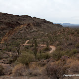
Let's see, I went for a hike today. I had planned to try to go up to the top of the Goldfield Mountains. I thought I was leaving the house about 1, but it turns out that I left after 3. I wouldn't have enough daylight to climb over 1000 feet. I was trying to decide what to do instead of my planned hike but didn't decide until I was out of the truck and walking. I decided to wander around on a rocky hill near where I parked. It was in the upper 50's and windy (about 15 mph), so I was glad I had worn a flannel shirt. On the down hill portion of the hike I even put some earmuffs on. I'm just not suited for cool weather. It was also overcast, so the pictures are terrible.

Here's a terrible picture showing where I went. I climbed just a little to the left of where the road points.
I wasn't really planning to go to the top of the hill. I just wanted to see what was over there. It turned out to be pretty easy to get to the top, though. At the top, it looked like it might be easy to descend on the other side. I had enough water, food, clothes, and stamina to backtrack if I had to, so I went for it. It was easy.

I had originally planned to hike up that canyon. It looks like there might be a cliff near the top that will block my progress. Only one way to find out.
I think I mentioned last time that I wanted to write a program to removed useless data from my GPX files that was causing EveryTrail to show me moving at 30 to 300 mph. I wrote the program this morning. It's a very simple program but it took me an hour or so to remember / re-learn enough Perl to write it. The totally amazing thing is that it did what I wanted the very first time I ran it. That's only happened once before (with a rather complicated memory test program) in my life that I can remember. It's not that I'm a bad programmer. It's just that it's almost impossible for a humid bean to do that much typing without making some typo, logical error, syntax error, or something that prevents the program from doing what is intended. Anyway, the program removed 76% of the track points from the GPX file. There's still one point where my speed jumps up to 12 mph. That's where I fell off a cliff. Just kidding. I think that is where something screwy happened with the satellites. My elevation is shown as dropping by 100 feet at that time, and that did not happen. Before the speed burst, my position is shown as being about 50 feet south of where I really was, then it suddenly jumps to being closer to correct. Maybe the data logger got another satellite signal or collected WAAS data and so it had a better fix on my position. That jump was in the data before I ran my program, so I didn't cause it.
Click below to see all of the pictures.
 |
| BC_2009_12_28 |
Sunday, December 27, 2009
Wandering around
I wanted to go someplace I hadn't gone before, but didn't want to drive much. I guess I wound up going someplace I haven't been too close to before. It was just before Apache Trail turns into a mountain road on the way to Canyon Lake. Bulldog Canyon OHV area is to the northwest. I went southeast. There is a small peak there that I thought I might climb.
Map your trip with EveryTrail

My destination is back there.

I also wanted to take a look at the old road back here. The peak I'm aiming for is on the right
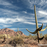
The weather was great and there were wonderful views all around. I think people used to drive out on that old section of road until the forest service fenced it off. There are a lot of cans, bottles, and shot up saguaros out there.

I thought I would be able to climb up the far side of that hill, but it isn't looking very promising from here.
I tried going up the side of the hill nearest me, but it quickly got too steep. I got out of the breeze and sat taking pictures for a while.

Weaver's Needle.

The Superstition Mountains.
Around the other side of the hill, there were some nice views of Bulldog Canyon.

Willow Basin.

I found another arch.
The other day I played around with editing the GPX file for a couple of hikes. I thought I had a way to get rid of the ridiculous spikes in speed that were showing up, but it wouldn't work with the GPX file for this hike. I decided that I need to write a Perl program to make the edits and installed it this morning. Then I discovered that I've forgotten a lot about programming in Perl. I'm sure it'll come back soon. In the mean time, I made hand edits to the GPX file. That took about 20 minutes. The speed graph looks reasonable, though. The data in the file indicates that my data logger wasn't able to navigate for about 84% of the time. I thought I had pretty good visibility of the sky, too. I'm starting to wonder if the data logger just doesn't work worth a hoot in cool weather. I'm going to move it back to the camera strap. Maybe my neck will keep it warm.
Map and pictures are below. Oh, I tried to turn off the picture slide show on the map because computers get bogged down if too many of those are running, but it didn't work. You can pause it, though.
Off trail 102
Map your trip with EveryTrail
 |
| 2009_12_26 |
Thursday, December 24, 2009
A view of Hackberry Mesa
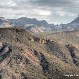
While I was on Hackberry Mesa about 3 weeks ago, I was looking at a mountain ridge to the WNW and thinking that I had probably been up there before. I decided then to climb back up there and take a look at Hackberry Mesa from over there, since I would know more about what I was looking at now.
Map your trip with EveryTrail
Map your trip with EveryTrail

The ridge I was looking at on November 27.
Yesterday was a beautifully sunny day (after a dark and rainy Tuesday) and I was able to get away from the house in time to climb the ridge. I had already planned my route a couple of weeks ago. It was an easy hike, but I moved pretty slowly. It was about 50 when I left the truck, with a very light breeze from the west. I was wearing a T-shirt because I knew I'd be warm going uphill. I didn't want to get sweaty, though, because then I'd be cold. I tried to move slow and made lots of stops, but sweat was dripping from my temples as I neared a saddle on the ridge. The view was wonderful and I stood on the ridge snapping pictures for a couple of minutes, but I was quickly getting chilled in the light breeze. I found a sheltered spot in the sun and put on my flannel shirt. Ahh, toasty!

Hackberry Mesa is on the left. If you look closely, you can see a little bit of Garden Valley.

First Water Creek is visible here. I had to stand in the shade to take this. Brr.

Weaver's Needle is on the left and the Superstition Mountains are on the right. I glanced at some pictures and thought I was holding the camera crooked, then checked the view and everything does seem to slope to the left.
You can probably tell from the pictures that it was a little hazy. I think that's moisture in the air from the rain the day before. The ground was soggy and there were puddles around. Also, the moss and resurrection plans were green.

Some very green moss.
I've been making EveryTrail maps of my hikes lately. One reason I've been doing that is because you can add pictures to an EveryTrail trip directly from a Picasa web album. In looking at the trips, though, there's something annoying. You can view a graph of altitude and speed versus distance. The graphs usually indicate that I sometimes move at 30+ mph for short bursts. I do walk fast sometimes, but I doubt that I exceed 4 mph. I decided that my GPS data logger is sometimes losing visibility of enough satellites to navigate for short periods of time. When it does get another fix, the sudden change in position makes it look like I moved very quickly. I had the logger on my camera strap, so it was normally positioned at my neck, over my left shoulder. I thought that maybe my head was blocking satellite signals and if a mountain blocks signals on the other side, the logger wouldn't be able to navigate. So I tried putting the logger on top of my hat. The first hike I tried that on showed I was moving in excess of 300 mph. Well, I was in some narrow canyons then. I should have had pretty good satellite visibility yesterday, though, and there are still several places where my speed is indicated as being over 20 mph. I think it's the mountains blocking signals. The graph for a walk I took around Brazos Bend State Park (flat as a pancake) has a much more believable speed graph. The map for this hike is below. I also included the Brazos Bend map, in case you want to compare.
Off trail 101
Map your trip with EveryTrail
Brazos Bend State Park
Map your trip with EveryTrail
Maybe I'll write a program to smooth out the data, some day when I'm feeling ambitious. Click below to see all of the pictures.
 |
| OT_101_2009_12_23 |
Monday, December 21, 2009
Hackberry Spring
I hiked out to Hackberry Spring today. I've wanted to do that ever since I saw the greenery down there. Gee, I guess it's only been 3 or 4 weeks. It was an overcast and gloomy day today. I liked weather like that when I lived in Houston, but here I like for it to be sunny (unless the clouds are thunderstorms). I can't wait for perfect weather to go for a hike, though.
Map your trip with EveryTrail
I could have taken the same route I took to Hackberry Mesa for most of the hike, but I wanted to try something different. Instead of following the bottom of a wash for most of the way, I followed a horse trail. The footing was much more solid; I like that. There's something about horse trails though. It seems that people that ride horses like to pretend they are on a roller coaster. The trails go up and down and up and down and up ... It's a workout. My legs were tired when I got done. I think I would have gotten some nice pictures along the way if the sun had been out. I thought I wasn't taking many pictures because it was so gloomy. I had 79 by the end of the hike, though.

It's so ... blah.

I saw a couple of red tailed hawks. This one watched me while the other one flew around screeching.

First glimpse of where the spring is. Blah.
That area seems to be a very popular place to ride horses. I didn't see any on my hike, but I could tell the had been there today. I know it was today because even though horses have very large bladders, puddles left yesterday would have dried by today.

Hackberry Spring. Yes, that's a pipe.

Flowing water!
There used to be a stock tank at the spring. Well, I guess there still is. I almost didn't notice it. It's buried by dirt, rocks, trees, and roots.
I created an EveryTrail map of this hike.
Hackberry Spring
Map your trip with EveryTrail
Click below to see all of the pictures.
 |
| 2009_12_21 |
Sunday, December 20, 2009
A hike near Broadway Cave
The weather was gorgeous yesterday. Also, I had just learned the day before that I didn't need to take a pile of work home to get done over the holidays. Time to do some exploring.
The trail that goes out to Broadway Cave in the Superstition Mountains continues past the cave to a canyon. I've wanted to see whats out there ever since I went to Broadway Cave (which was over a year ago, I think). I got an early start since I knew it would take a while to get out to where I wanted to start exploring.

The parking area is only big enough for 4 or 5 vehicles. Fortunately, somebody was about to leave when I pulled up.

Broadway Cave is that hole on the right. The Superstitions look dull from this angle at this time of day.

The eastern end of the Superstitions.
I saw 5 other people near the beginning of the trail, which is about the most people you can see considering the size of the parking lot. There was a light breeze from the east the whole day, which served to blow away the sounds of suburbia. I hesitated to go on this trail because the last time I was on it I listened to yapping dogs and loud motorcycles the whole time. I didn't hear much of that this time.

I took another picture like this. That's two in the past week. I've about worn that out.
The views don't change a lot along this trail, so in a way it's a little boring, though this is a great way to be bored. It took me an hour to get to the part of the trail I wanted to explore.


The view shifts slowly as you climb the trail.

The trail enters a canyon.
Soon after entering the canyon, the trail comes to the remains of a hearth. The rest of the building is gone (assuming there ever was a building). It seems to be a popular destination. People stop there to eat a snack, and leave their trash. Maybe they think their mother will be by later to clean up after them.

Hearth at the canyon entrance.

Why did somebody bring a newspaper out here? The date on it is December 23, 2008.

It looks like whoever built the hearth dug a large hole.
I wandered around out there for a little while. The trail continued up the canyon, but it wasn't really a trail anymore. It followed the bottom of the canyon and so involved a lot of climbing over boulders. Slow going and tiring. I didn't feel like doing that, and I wanted to get back before sunset.
I came across several large "fields" of large boulders in the canyon. They didn't look like they had fallen from up above. It seemed strange how uniform the size color of boulders was in each one. One had dark gray boulders that were 2 to 5 feet in diameter. One had light tan boulders that were 1 to 2 feet in diameter. Nothing grew up between the boulders. The gray boulder field was about 6 feet thick; I know because somebody had blasted or sledgehammered their way through to the bottom (my theory is a guy proposed to his girl there, and they dropped the ring into the boulders and the guy spent 3 weekends out there with a sledgehammer to get it back).

A large field of large boulders.

A hole dug to the bottom of the boulders.
On the way back I noticed something orange about 30 yards to the right of the trail. I went over to investigate and there's another large pit there. There are a lot of these in the Superstitions and I always wonder why a person decided to dig right there.

A pit in the middle of nowhere.
I was almost back to the truck about 30 minutes before sunset when I saw a guy coming the other way. He was wearing camo and carrying a compound bow. He asked if I'd seen any deer. I said that I very rarely see deer. As we passed each other I said that I think I'm too noisy and scare them away. He kept walking, turned his head slightly, and said, "Have a nice day". What I heard, though, was "I'm done with you; go away and leave me alone". I continued walking and glanced back occasionally. When he was far enough away, I stopped, turned, and called out very loudly, "GOOD LUUUUUCK". Hopefully, I spooked any deer within half a mile. That was petty, but it was fun. Click below to see all of the pictures.
 |
| 2009_12_19 |
Friday, December 18, 2009
Wandering by the Salt
On Wednesday I got tired of the constant battles I was having to fight at work (with software and machines, not people), so I decided to leave a little early and get out to the desert for some relaxation. It had been more that a week since I'd been out there. It was too gloomy to hike last weekend and I've been very busy during the week. I had to think of someplace close to go, because the sun would be setting soon.
I headed over to the Salt River and went to an area I haven't been in for a couple of years. There's a large bare patch of ground there. I'm beginning to think that if there aren't enough rocks in the dirt in the desert, the dirt will be bare (except maybe after rain). Not sure why that is, though.

Large bare patch.

I found a little fall color as I got closer to the river.
As I got closer to the river, I was wondering if I would be able to find any coins or jewelry with a metal detector. People loose a lot of stuff like that while tubing on the river. I quickly realized that might not work, though. Unless your metal detector is good at discriminating against aluminum, you aren't going to find anything but beer cans. There were a lot scattered around, and lots of caps, t-shirts, and shoes.

Looking back towards the Goldfield Mountains.
Near the river, the ground is covered with lots of lose river rock. It's treacherous footing. It actually felt good to be walking around on something like that again. I didn't know I would miss something like that.

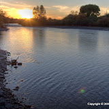
The view of the river.
I got to the river just before sunset and headed back to the truck so I wouldn't be wandering around in the dark. It was a nice get-away.
 |
| 2009_12_16 |
Tuesday, December 01, 2009
Gila Monster video
I was browsing through old pictures and videos today and came across this video of a Gila monster that I made on May 6, 2004. I was on the Massacre Grounds trail and the lizard was in the middle of the trail. It's the first of two Gila monsters that I've come across in the desert.
Monday, November 30, 2009
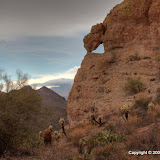
Another stone arch
It's not a spectacular arch, but it is an arch. I got a picture of it on my way to Hackberry Mesa on Friday. Here's a better picture of it.

Looks a little like a witch's nose.
It was cloudy when I left the house, especially to the east. I didn't believe it would rain where I was, though. When I got out of the truck, it seemed like it was getting darker. I thought I heard thunder once or twice along the trail but decided it was wishful thinking. The first mile or so of this trail is in a wash, so I couldn't see much of the sky. Then I rounded a corner and had a view to the east. It sure seemed like those dark clouds were closer.

Ominous clouds
I was at the arch by now, so I started climbing to get a better view of it. I got to the top of a small ridge and had the view below.

I can see rain, now. Hmm.

I was also very close to the arch.

I got a few pictures of the arch. That's Four Peaks in the background with a cloud on top.

Then it got very windy and started to sprinkle.
The wind started blowing pretty hard. I put my chin strap on to keep my hat from blowing away and got my poncho out. It was too windy to try to put it on, though. I held it over the camera and started down. The ridge blocked the wind and I put the poncho on. Hiking while wearing a cheap plastic poncho is almost as bad as hiking without one. You get wet anyway because your sweat can't evaporate, and you will sweat when you are wrapped in plastic.
The weather was exciting, but it didn't rain enough to make even a small puddle anywhere. It did get the gravel in the wash damp, and the gravel seems to be more cohesive when damp. Made walking a little easier. I headed back to the truck because it looked like it was going to rain for a while, but it was clearing to the east by the time I got there.

Sunshine on Four Peaks.
Click below to see all of the pictures.
 |
| 2009_11_29 |
Subscribe to:
Posts (Atom)


