
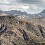
The ridge I was looking at on November 27.
Yesterday was a beautifully sunny day (after a dark and rainy Tuesday) and I was able to get away from the house in time to climb the ridge. I had already planned my route a couple of weeks ago. It was an easy hike, but I moved pretty slowly. It was about 50 when I left the truck, with a very light breeze from the west. I was wearing a T-shirt because I knew I'd be warm going uphill. I didn't want to get sweaty, though, because then I'd be cold. I tried to move slow and made lots of stops, but sweat was dripping from my temples as I neared a saddle on the ridge. The view was wonderful and I stood on the ridge snapping pictures for a couple of minutes, but I was quickly getting chilled in the light breeze. I found a sheltered spot in the sun and put on my flannel shirt. Ahh, toasty!

Hackberry Mesa is on the left. If you look closely, you can see a little bit of Garden Valley.

First Water Creek is visible here. I had to stand in the shade to take this. Brr.

Weaver's Needle is on the left and the Superstition Mountains are on the right. I glanced at some pictures and thought I was holding the camera crooked, then checked the view and everything does seem to slope to the left.
You can probably tell from the pictures that it was a little hazy. I think that's moisture in the air from the rain the day before. The ground was soggy and there were puddles around. Also, the moss and resurrection plans were green.

Some very green moss.
I've been making EveryTrail maps of my hikes lately. One reason I've been doing that is because you can add pictures to an EveryTrail trip directly from a Picasa web album. In looking at the trips, though, there's something annoying. You can view a graph of altitude and speed versus distance. The graphs usually indicate that I sometimes move at 30+ mph for short bursts. I do walk fast sometimes, but I doubt that I exceed 4 mph. I decided that my GPS data logger is sometimes losing visibility of enough satellites to navigate for short periods of time. When it does get another fix, the sudden change in position makes it look like I moved very quickly. I had the logger on my camera strap, so it was normally positioned at my neck, over my left shoulder. I thought that maybe my head was blocking satellite signals and if a mountain blocks signals on the other side, the logger wouldn't be able to navigate. So I tried putting the logger on top of my hat. The first hike I tried that on showed I was moving in excess of 300 mph. Well, I was in some narrow canyons then. I should have had pretty good satellite visibility yesterday, though, and there are still several places where my speed is indicated as being over 20 mph. I think it's the mountains blocking signals. The graph for a walk I took around Brazos Bend State Park (flat as a pancake) has a much more believable speed graph. The map for this hike is below. I also included the Brazos Bend map, in case you want to compare.
Off trail 101
Map your trip with EveryTrail
Brazos Bend State Park
Map your trip with EveryTrail
Maybe I'll write a program to smooth out the data, some day when I'm feeling ambitious. Click below to see all of the pictures.
 |
| OT_101_2009_12_23 |


No comments:
Post a Comment