I also figured out how to make the map default to satellite view, but you can change that easily while looking at the map. Also, click the play button at the bottom of the map to view the slide show.
Let's see, I went for a hike today. I had planned to try to go up to the top of the Goldfield Mountains. I thought I was leaving the house about 1, but it turns out that I left after 3. I wouldn't have enough daylight to climb over 1000 feet. I was trying to decide what to do instead of my planned hike but didn't decide until I was out of the truck and walking. I decided to wander around on a rocky hill near where I parked. It was in the upper 50's and windy (about 15 mph), so I was glad I had worn a flannel shirt. On the down hill portion of the hike I even put some earmuffs on. I'm just not suited for cool weather. It was also overcast, so the pictures are terrible.

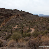
Here's a terrible picture showing where I went. I climbed just a little to the left of where the road points.
I wasn't really planning to go to the top of the hill. I just wanted to see what was over there. It turned out to be pretty easy to get to the top, though. At the top, it looked like it might be easy to descend on the other side. I had enough water, food, clothes, and stamina to backtrack if I had to, so I went for it. It was easy.

I had originally planned to hike up that canyon. It looks like there might be a cliff near the top that will block my progress. Only one way to find out.
I think I mentioned last time that I wanted to write a program to removed useless data from my GPX files that was causing EveryTrail to show me moving at 30 to 300 mph. I wrote the program this morning. It's a very simple program but it took me an hour or so to remember / re-learn enough Perl to write it. The totally amazing thing is that it did what I wanted the very first time I ran it. That's only happened once before (with a rather complicated memory test program) in my life that I can remember. It's not that I'm a bad programmer. It's just that it's almost impossible for a humid bean to do that much typing without making some typo, logical error, syntax error, or something that prevents the program from doing what is intended. Anyway, the program removed 76% of the track points from the GPX file. There's still one point where my speed jumps up to 12 mph. That's where I fell off a cliff. Just kidding. I think that is where something screwy happened with the satellites. My elevation is shown as dropping by 100 feet at that time, and that did not happen. Before the speed burst, my position is shown as being about 50 feet south of where I really was, then it suddenly jumps to being closer to correct. Maybe the data logger got another satellite signal or collected WAAS data and so it had a better fix on my position. That jump was in the data before I ran my program, so I didn't cause it.
Click below to see all of the pictures.
 |
| BC_2009_12_28 |


No comments:
Post a Comment