Thursday, April 30, 2009

Draggin'

All day at work on Monday I felt really strange, like maybe I was coming down with something. I had a lot of trouble thinking and remembering things, which isn't good when most of your work involves thinking. When I went home, I played couch potato until I went to bed. Felt much better on Tuesday. Then on Wednesday I didn't feel quite right again. I decided that I probably needed to go for a hike. I didn't feel up to a strenuous hike, so I went to a quiet part of Bulldog Canyon to wander around.


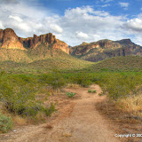
It was a good choice. It was quiet out there. The planes flying in to Sky Harbor weren't going over Bulldog Canyon for once. I didn't see anybody else while I was out there. I love it when I have the desert to myself. It still boggles my mind that that is even possible this close to a large metropolitan area. What is wrong with people? Why would 5 million people rather watch tv or eat in a noisy restaurant or hang out in a bar with a bunch of shallow drunks than spend a couple of quiet hours in one of the most beautiful places on earth? I don't know, but I'm glad they do that. The desert is MINE and I love it! But I digress...


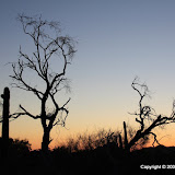
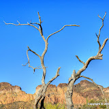
I just kind of wandered around to some place that I hadn't wandered to before. Along the way I came across a dead tree that looked very familiar. I think I took some pictures of it about 4 years ago.


Have you seen this before?


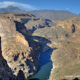
I wound up near a place where part of a cliff had fallen off recently. I think it was very recently. I didn't spend much time trying to figure out how recently, but I think it was more than 6 months but maybe less than 10 years. Maybe even less than 2 years. I'll have to see if I can find it on some old pictures.


I wandered up close to the cliff but stopped before I got there. It got too steep. I sat there a while enjoying the view and the quiet. On the way down, my legs were shaky. I must be coming down with something, or maybe I have it and this is as bad as it gets.


Click below to see all the pictures.


BC_2009_04_29

Sunday, April 26, 2009

Trip map

I've been meaning to make another @trip map for a while. I have an idea for one that I want to do, but I will need to concentrate on it for a few hours to get it done, so I haven't bothered to start. Anyway. I did make one for yesterday's hike. Click on the map to open a new window for the trip. If that doesn't work, click someplace else on the map, especially someplace that doesn't look clickable.


Return to an old trail

I suppose that if you want to get technical about it, they are all old trails. What I mean is, I hiked this trail a long time ago. I don't know the name of it. It's down FR80, which is east of Tortilla Flat.


I had tried to geotag pictures I had taken on that trail before, but it was in a low resolution area of Google Earth so it was very difficult to tell what was where. It's high resolution now, but I'm not sure that would have helped with the geotagging. I don't think it's an official trail, so it isn't used much, so it's difficult to see even with the high resolution. I have my igotU, though, and so now it's easy to geotag the pictures and to tell where I actually was.


Speaking of the igotU, I downloaded an update to the software yesterday. It has some new features, and I was hoping it would fix the occasional crash I've been experiencing. Well, the first time I used it after the update, it crashed. Rats.


Whoa, I just looked at the @trip web site. I seem to be first on their list of featured authors, and here I am trashing their software. Wait, I'm not trashing it. I just described what I experienced. I trash microsoft software, not @trip software. But I digress.


In looking at the placement of the pictures on Google Earth, it looks like the trail is halfway up a vertical cliff. I guess when I think back to the cliff going straight up to my right and the vertical drop just a little to my left, that is probably correct.


Looking back at the parking area.


The Supes can be seen from the trail.


No, I didn't hold the camera crooked. The ground slopes to the west.


I got pictures of another fish hook pincushion cactus flower.


It was very windy, which can be annoying but was very nice. It kept the gnats away and kept us cool (it was only in the mid 80's, too). One reason I picked this trail is it's away from the valley, and I hoped it would also be away from the dust being stirred up in the valley by the wind. It did seem a little less dusty out there.


Had a good view of the river/lake this time.


There's a nice view from here.


FR80_2009_04_25

Thursday, April 23, 2009

Not enough light

I got home from work early enough on Wednesday to go for a hike. I wanted to go someplace different but not too far away. I decided to climb the hills/mountains across Bush Highway from the Salt River. I had a nice view of Bulldog Canyon OHV area from up there. I took a bunch of pictures of it but didn't think about putting them together for a panorama until I was looking at the pictures today. I don't know if my photo stitching software has trouble with HDR images or what, but it didn't do a real good job of putting them together. Still, the panoramas don't look too bad.


I looked for an area of the hills that didn't look too steep. It was conveniently located by a place to park, with a gap in the fence for hikers. A trail headed for the hills and I thought I might find one all the way to the top, but it pretty much ended when it intersected a horse trail. There are a lot of trees in that area, I guess because it's so close to the river. I wandered through them to get to the hills. The trees ended at their base.


I probably got about halfway to the top before I decided the sun was too low to go any further. The view was nice from up there. There were an awful lot of chollas up there. I bumped one with my knee pretty hard on the way down. I had to find a rock to sit on, get the pliers out, pull my pants leg up and pluck thorns for a while. Finding a rock to sit on was not hard. You'll see what I mean in the pictures.


The canyon I've been trying to get to lately is over there.


Pass Mountain, Lone Mountain, Horseshoe Mountain, and Spooky Hill are in this picture.


Rocks aplenty.


A tree with two trunks.


There is only one of these out there.


The panoramas, a 3D picture, and more are in the album.


2009_04_22

More nighthawks

The last time Suzanne and I went to listen to nighthawks, our favorite parking spot was taken. In fact, Bulldog Canyon was downright crowded that night. I bet we saw 15 people. Well, we went again on Tuesday. Didn't see anybody else out there. This time we remembered to bring chairs and a cooler packed with beer and wine coolers. We watched the sunset and listened to the nighthawks. It was a nice, relaxing evening. Oh, and I took a few pictures before it got too dark.


Four Peaks in the distance, with that deep wash in the foreground.


Zoomed in some.


Zoomed in more.


I had some fun with the clouds.


BC_2009_04_21

Sunday, April 19, 2009

A hiker falls

On Friday there was something in the news about a hiker that had fallen in the Superstition Wilderness area and had to be rescued. There was an article in the paper and lots of comments on it. A lot of the comments said people shouldn't hike alone, or only experienced hikers should hike alone, etc etc. Below is a copy of a comment from one of the hikers relatives. The description of the situation surrounding the fall is just the type of thing I make a point of avoiding. I have a lot of rules for myself when I go hiking, and one of them is, "Do not get close enough to a cliff such that if I slip and then slide or roll for what seems a ridiculously long distance, I would go over the cliff." The safe distance depends on the steepness of the slope above the cliff, if I'm on a trail (not likely to crumble away), condition of the ground, etc. I sometimes hike on pretty steep slopes, but in those cases I would have to roll many many yards, and miss all the cacti and trees on the way, to go over a cliff. It seems that maybe this guy didn't have a rule like that. I suppose it's also possible that he didn't know he was that close to the edge.


I saw your comment about my family member, and I just had to respond. Rest assured he is alive because he was so prepared. He had a first aid kit-he boud his own wounds- rationed his water. He fell about 50 feet. He was on top of the mountain, near second water- about 10 feet away from a sloping area that went off the edge, headed back down. He steped and the ground gave way, a chunck of the top soil just started to slide and it sent him off the edge along with dirt and rocks, it took about 1 second and he was over the edge. Most likly due to all the much needed rain. I agree- hiking alone- not the best idea in rough country, but those Eagle Scouts are prepared. It was a crazy freak thing. I am not sure anyone would ever dream of that happening. I am eternally greatful to the men and women who did not give up on him and God. Maybe this changes your mind? Maybe not. But now you are informed.


I wouldn't say the guy was careless without knowing more about the situation. He was more prepared than me in some ways; I don't carry first aid supplies. I figure that if I need a bandage, I'll end up with a missing sleeve or a short pants leg or something. He doesn't seem to have a SPOT satellite messenger, but I regard that the same way my father always felt about 4 wheel drive vehicles (it just means you can get stuck better before somebody has to pull you out). Taking chances because I've got a SPOT would be stupid. What if that chance results in a concussion, a broken SPOT, or a broken leg in a canyon where there is no visibility of the communication satellite? I'd be toast. When you start to feel safe is when you are in the most danger. Stay alert.

Saturday, April 18, 2009

Curses, foiled again

Remember Snidely Whiplash? Never mind.


I made another attempt to get to that canyon today. I thought I'd try a route near the river, hoping I wouldn't have to go up and down as many hills or washes. It was flatter. I made pretty good time for most of the way, maybe because I wasn't taking near as many pictures.


The Salt River


Somebody had a coral down here.


The view along the way.


I was trying to keep from getting too close to the river, mostly because of bugs. They seem to hang around in damp places. I finally got to a point where I either had to push through bushes and trees by the river or climb over a large hill. I didn't want to do either of those. I started back to the truck but the decided to follow the river for a while. It was pretty buggy down there. Also, there's a lot of soft sand, which makes walking very difficult. On the plus side, it's pretty down there.


The Salt River


Red winged blackbird


Next time, I think I'll follow along the river a little further. The foliage thins out there and I might be able to get to the canyon.


BC_2009_04_18

Friday, April 17, 2009

At last! High res pictures of the Superstition Wilderness in Google Earth

For years I've felt frustrated every time I looked at the Superstition Wilderness in Google Earth. I kept asking myself, "Why don't they make the interesting areas high resolution? Who wants to see a bunch of houses? I could tell that my brother's truck was parked in my driveway (we carpool) when the picture that included my house was taken. But so what? I wanted to be able to follow the Massacre Grounds trail. I wanted to be able to tell where I was standing when I took pictures of agave stalks against the sunset. I wanted to be able to find cool new places to hike. I wanted to be able to tell where the Canyon Lake Vista pullout was. Finally, I can. Well, I've got a lot of that stuff geotagged now, anyway. For the past week I've been looking at trails I've been on and trails I'm going to be on. Check it out.


OK, moving on. It's the time of year for watching goatsuckers. No, not chupacabras. Maybe you know them as nighthawks. Also, they are mildly interesting to watch, but the really cool thing is the sounds they make. Sometimes they sound like monkeys in a jungle. I'll have to try to get a recording of them. Suzanne and I went out to listen to them tonight. Bulldog Canyon was full of people. We didn't see (or hear) a lot of nighthawks, either. We'll have to go again. I tried to take a few pictures, but it was dark and landscape pictures just don't work with a flash ;) Anyway, click below to see the pictures.


BC_2009_04_17

Monday, April 13, 2009

Just to the beginning

There's a canyon in Bulldog Canyon OHV area that I've wanted to explore for quite a while. I haven't been able to find a way to get to it, though, except for walking a long way. For a while I thought I might be able to wade across the Salt River to get to it, but the Salt is deeper than I thought. There aren't any official roads that go out there, so I can't take the ATV. I decided I'm just going to have to walk. My scouting trip last Tuesday was to check out the first part of the route I planned to take. The scouting trip made the first part of Sunday's hike easier and quicker.


View Larger Map
The canyon I want to explore.


Still, it took me two hours to get to the beginning of the canyon. I had to cross several washes with steep sides, so my legs were tired. I really like my new boots. They provide great protection for my feet and ankles. Still, it was mostly very rough terrain, so my ankles were getting achy. Yep, just when I got there, I turned back. Well, I had fun, saw lots of cool stuff, and learned a few things to apply to the next attempt. I'm out there to have fun, not to prove anything, so I'm not going to push myself to injury or danger.


On the drive out to my parking spot, I saw lots of colorful flowers on buckhorn cholla. I hadn't realized before how much variety there was in the color of its flowers. I decided I would try to get a picture of each color on the hike, but quickly realized I didn't have time to take that many pictures.


It's almost like looking at a rose garden.


The canyon I want to explore is on the other side of that ridge.


If I could use some of the illegal roads, this would be much easier. They go right up to the canyon entrance.


Some of the roads I can't use follow the power lines, and may be used by servicemen.


I took this balloon back to my trash can.


The ridge from up close.


The roads come right up to where I stopped hiking, which explains why I found a beer bottle up there.


Here's the canyon I want to explore. It's much bigger than this picture makes it look.


There were kayaks on the river. I could hear the people in them when I couldn't see them. I could hear a radio playing lousy music, too, but I think that was coming from the park near the bridge.


Looks like a trail going into the canyon. I have GOT to get on that trail.


I had a big surprise on the way back. I was almost to the bottom of a wash. The side got steep at the bottom, but it looked like solid rock with lots of bumps and knobs to step on. I stepped on a bump and it broke off. I didn't fall, but the adrenaline kept me engergized for a while.


There are lots more pictures on the web album.


BC_2009_04_12

Saturday, April 11, 2009

Pictures of the Salt

It's been a stormy day. I had been planning all week to go on a long hike today, but not in the rain. It looked like the sun was trying to come out this afternoon, though, so I went out for a little while.


I went down to the Salt River. I wanted to get a picture of a particular item there, but I couldn't find it. There were some clouds around that made for nice landscape pictures, though.


There's a spot to park next to the road, and this is the view as you walk to the river.


A lot of the pictures look like this, but hey, it was pretty.


The walk down to the river was not very pleasant. I kept thinking I smelled something that had died a few weeks ago. I didn't get away from the smell until I got right next to the water. Well, at least it wasn't the river that stunk.


I found some fungus.


Lots of people come down here, or float through here, so there's lots of junk.


Now is the time to kayak on the river; no drunken knuckleheads to put up with.


2009_04_11