Sunday, February 19, 2012

Dutchman's Trail, first attempt

It shouldn't have been a "first attempt", but that's the way it worked out. I was on a heavily traveled (i.e. smooth) trail with lots of food and water and daylight. But things happen.

I had been thinking about hiking on some trails accessed from the Peralta trailhead all week. I got out my map of the Superstition Wilderness on Friday evening and planned my route. I wanted to get pictures of Miner's Needle (strangely, there are very few pictures of that area on Google Earth), so I was going to go in that direction first. I was a little concerned that the parking lot might be full at this time of year, so I had a backup plan to get pictures of the mushroom rock.

On Saturday morning, the paper had an article about the Peralta trail. I figured the parking lot and the overflow parking lot would be full for sure because of that. I decided to check it out, anyway, but was pretty sure I would be going to the mushroom rock. I was surprised to see that the dirt road had had water sprayed on it (to keep dust down) as I left the pavement of Peralta road. Wow, were they expecting a lot of traffic today?

Well, it turned out that there were lots of spaces available in the parking lot. I took my time going up the hill at the beginning of the trail. I might be hiking 8.5 miles, so I didn't want to get worn out at the beginning.


A parking lot with empty spaces.


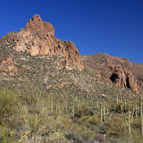
The first sight of Miner's Needle, near the beginning of the trail.

It was a gorgeous day; clear sky and temperatures in the mid 60's. Yes, I had sun screen on. I was a little concerned about the fragrance attracting bees. Sure enough, as soon as I got out of the truck, a bee tried to fly up my sleeve. That was the only one that took any interest in me, though.


Miner's Needle is on the left.

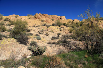
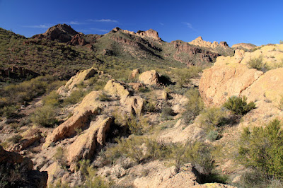
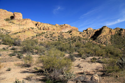
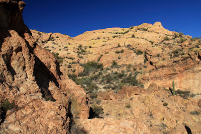
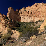
The beginning of the trail overlooks what I would call a valley, but maps call the northeast end Miner's Canyon and the southwest end Barks Canyon. I took several panoramas of it and the mountains around it. I uploaded them full-size, so you can zoom way in. I took over 200 pictures and uploaded most of them to the web album. I tried to get saguaros in them so they wouldn't be a bunch of pictures of the same mountains over and over again, but that might be what they look like, anyway. It was the middle of the day, too, so I don't like the looks of most of them. I had to plan to be there in the middle of the day, or I would probably have been hiking in the dark for several hours.

I saw about 10 other people on the trail. A couple that looked older than me saw me taking pictures of Mexican Gold Poppies and told me there were thick fields of them further up the trail. I decided to make seeing them my goal. My left ankle has been acting up lately and if it started to hurt much, I was going to turn back. It was feeling good at the time, though.


A picture of a saguaro with a mountain in the background.

Let's see, I need to back up a little bit. At work on Friday, I was walking down the hall and noticed that a spot on my lower calf was a little tender. That seemed odd because I hadn't done anything that could have injured it. So I'm walking along this trail, and that spot on my calf is still very slightly tender but easy to ignore. Then I took a step, just like the hundreds of previous steps I had taken on this hike, but this time it felt like a knife had been jabbed into my calf. It wasn't a cramp. It hurt when I tried to use the muscle. It hurt when I tried to stretch the muscle. It felt fine when I did nothing, which was nice, but you can't do nothing when you're on foot in the middle of the desert. I sat and rested for a few minutes. It felt no better. I walked very slowly, hoping it would ease up. It didn't. I was forced to take very small steps. I felt like I was crawling. I had no choice but to turn back.


Before I turned back, I took several pictures of 3 Mexican Gold Poppies. Most of the poppies have been tattered by the wind or are missing a petal or are stunted or have some sort of defect. Not these 3 (two pictured here). These are the megababe supermodels of Mexican Gold Poppies.

I didn't make as many stops for pictures on the way back, so that made up for moving slower. I thought I was only going about 1 mph, but my GPS track indicates that I was still moving at almost 2 mph. Every step hurt, though. I don't know if it's from me walking funny or if it was going to do it anyway, but my left ankle started getting achy, too. By 2 this morning it hurt so bad I couldn't tell if my calf still hurt. I'm going to have to figure out what's causing that and fix it. I was limping on both legs by the time I got back to the trailhead, which looks really pathetic (the limping, not the trailhead). I tried to walk normally but very slowly and tried to make it look like I wanted to walk slowly. That was difficult because I don't like walking slowly and tiny steps just don't look natural.


A hawk posed for pictures.


Blue Lupine.

Having to turn back was very frustrating. It was such a beautiful day, though, I couldn't be in a bad mood. Click below to see all of the pictures.

2012_02_18

Monday, February 13, 2012

The Lost Goldmine Trail, and the location of all that gold

Sunday was another beautiful day, and about 15 degrees cooler than Saturday. I went for a drive down Peralta road, because I hadn't been out that way for a few months. There was a lot of traffic; cars, trucks, and ATVs. A lot of people were leaving the Peralta trailhead. I guess most people start their hikes earlier in the day than I do, and they were done hiking and were heading home or to lunch. I stopped at the Lost Goldmine trailhead and read once again about the legend of the Lost Dutchman's gold. The gold was lost, not the Dutchman, and he wasn't Dutch; he was German. Next I stopped at what is now the Carney Springs trailhead. It was such a pretty day, and I didn't have to be anywhere else, so I got my back pack and started walking. I headed west on the Lost Goldmine trail when I got to it. Before I knew it, I was at the mine. Just kidding.


I told myself that I wasn't going to take any pictures of The Three Sisters because I already have so many, but you know how that goes.


Turns out that if you found the mine, you couldn't go in it to get the gold anyway. ;-)

As I strolled along, I thought about the lost mine. Thousands of people have spent over 100 years searching for the mine, and many have died. I keep an eye out for it whenever I'm in the Superstition Mountains, but I haven't spotted it yet. Then I thought that maybe I should get some of the maps floating around to increase the odds that I would find it. Then I thought that lots of other people have thought that, and look how successful they've been. So the logical conclusion is that I'm better probably better off without any maps. Then again, maybe I should get some maps so I know where NOT to look, because thousands of people have already looked in those places. My Dad once accused me of thinking too much.


I like walking through here. You feel like you're in a really dense saguaro forest.


I took lots of pictures of saguaros, with mountains in the background of most of them.

So now I know where to look, which is in the places that everybody else hasn't looked yet. I think that's probably a lot of places. I've checked two or three of them already. Gettin' closer.

Next, I thought about what I would do if I found it. Well, supposedly there's a curse on it and I might wind up dead. That wouldn't make finding it worthwhile. If I found it and word got out (might be hard to cover up selling a bunch of gold), then there would be no more legend and that would spoil a lot of people's fun. They would have to make up other excuses to wander off into the desert, unprepared, in the summer heat.


If you look at enough saguaros, you're going to find a few that look strange.

So I decided that if I do find it, there's only one thing to do. Keep it a secret. I won't even tell My Sweetums.


Dead trees almost always look interesting.

So if you don't read a blog post in which I claim to have found the mine, then you know for a fact that I have or haven't found it. Hmm, that kind of correlates with my strategy for finding it in the first place, sort of. Click below to see all of the pictures. Oh, and remind me to tell you about my plan for finding hundreds of thousands of dollars worth of meteorites.

2012_02_12

Sunday, February 12, 2012

Busted

I often rant about people doing things in Bulldog Canyon OHV area that they shouldn't be doing. Oh a couple of occasions I've argued with members of church groups that wanted me to let them in without a pass. People often leave the gates unlocked or wide open. I often feel like I'm cleaning up after a bunch of thoughtless and selfish teenagers. When I got to the Blue Point entrance yesterday, the gate was opened and nobody was around. I should have closed it, but I was fed up. I could just imagine the knuckleheads driving up as I closed it and b****ing at me for being a goody-two-shoes. So I just drove through. One time in about 7 years of going out there, I left the gate open. My first willful transgression. Half a mile later, I was pulled over. The officer was very polite and told me to close the gate even if I didn't open it, and that was that. So glad I didn't get banned from the area. Anyway, I'm not putting up with any more crap from the knuckleheads. If I'm going to get reprimanded for the one time I leave the gate open, then the next person to give me grief about closing the gate is going to be talking to the Maricopa County Sheriff's Office (MCSO). The next knucklehead I see tearing up the desert is going to have enough pictures and movies provided to the MCSO to net them a hefty fine. If I'm going to get pulled over for leaving one gate open once in 7 years, the real jerks are going to answer for their idiocy, and MCSO is going to get tired of hearing from me.

OK, enough of that.

I went out there because I wanted to do a little climbing and because I wanted to look for a stone arch that I thought I saw out there about 5 years ago. Unfortunately, I don't know exactly where I was when I saw it. That was before I had a GPS logger. I remember that I could not have gotten to the arch from where I was when I saw it, and I remember thinking I might be able to get to it from 10. I thought I could even see a faint trail near the arch. So I drove to where I thought I might be close to the arch and headed up the ridge.


I've always called this Dome Mountain, but I think Dome Mountain might actually be behind this.

The ridge looked suspiciously short, and I suspected I would see a much larger ridge behind it. I was right. I tried to get to the other ridge but it was too steep. I was sliding downhill.


When I got to the top of the ridge, I found a shady spot to cool off.


I tried going along here to get to the real ridge, but it was to steep to safely walk across.

As I was looking around and taking pictures, I realized that some pictures might not make sense to other people because they don't have any idea what direction I was facing. Well, I'm not sure it would help if they did know that, but I was in a convenient spot to make a 360 degree panorama, so I did that.


360 degree panorama from the short ridge.

As I drove out, I noted some other places to explore in the future. They don't look very accessible, though. It should be fun finding my way around out there. Click below for all of the pictures.

BC_2012_02_11

An afternoon stroll

If you want to go for a walk just to go for a walk, a good place to go is over by the Superstition Mountains. The scenery is nice and you might get some good pictures. I headed over there after work on Thursday. The days are getting long enough to hike after work now. I parked at the Crosscut trailhead. There was only one other vehicle there.


A stand of cholla along the way.

There was just a very light breeze. It was very peaceful and relaxing out there. I had been along the same trail about a year ago and didn't see much on either side because I was focused on reaching my destination and on the way back I was just too tired (and it was dark). Since I didn't have to be anywhere before sunset on this hike, I wandered off the trail now and then checking things out. I didn't see anything real exciting, but at least I saw it.


I've done a lot of hiking in those mountains.

Every once in a while, I thought I heard voices, and would stop and listen and then decide it was the wind playing tricks on me. Eventually, though, I heard the voices even while crunching along the path, and I could tell what direction they were coming from. It must have been the people from the other vehicle. Looked like a father and a couple of teenagers.


The other hikers.

I turned back soon enough that I would get back to the truck well before it got dark. I felt like I had to keep stopping to look around for good picture opportunities as the sun sank.


Clouds to the west let the sun illuminate portions of the landscape.


The filtered sunlight made cholla look like they were glowing.


I see lots of cool stuff on my hikes, but pictures of the Supes always seem to turn out more impressive than all the other stuff.

It was a pretty sunset. I almost missed it as I concentrated on not twisting an ankle on the last little bit of the hike to the truck. Click below to see all of the pictures.

2012_02_09

Sunday, February 05, 2012

Yet another ridge in Bulldog Canyon

I wanted to see something new yesterday, but I didn't want to drive a long way to see it. I went to Bulldog Canyon and started down a wash I've been down a couple of times before, and then headed up a ridge. It's one of the places along there that I'm planning to explore some day.


I went up there, sort of. There's not much for scale, so this doesn't look like much.

I went up one of those bare rock ridges out there. If you can find spots that aren't too steep, they are easy to walk up because they aren't covered with loose rocks. On the other hand, they can be covered with marble sized pebbles that roll under the hard soles of my hiking boots. Progress can be slow on slopes with those pebbles. That was OK, though. I had donated blood in the morning and seemed to be getting out of breath more quickly than usual.


You can't see all this structural detail from down in the wash. It just looks like a solid orange wall.


There are several large, flattish spots up there. I decided to head for that notch towards the right. I want to see what's on the other side.

I crossed some sizable "flat" areas on the way up. It's nice to be on ground that you don't feel like you're about to roll down every now and then. Some of those areas were covered with thick grass about mid-calf high. It was tricky walking there because the softball size rocks were hidden. I almost twisted an ankle in one of those spots.


Treacherous meadow.

I took my time on the way up, partly because it was pretty up there and partly because I needed to catch my breath a lot. I also spent a lot of time studying optional routes to decide which way to go. You can't really tell which way will work out until you try it, though. I got lucky and made it to the top of the ridge on my first attempt.

I need to go in that direction, but I don't want to hike in the bottom of that draw. Vegetation will be too thick.

I steadily and easily made progress. It was a little strange not coming to any dead ends. The route I chose wasn't very steep, either.


Steadily gaining altitude.

I eventually got to a spot where I was going to have to go up a narrow channel that was full of plants. I expected to get ripped to shreds. There was no catclaw, though. I was able to get past all the other thorns without losing any blood.


The most formidable obstacle.


A nice view.

At the top of the channel, it looked like I was almost to the top of the ridge. It was tempting to run the last few feet and check out the view. There was a chance that I would get up there and see that I had a lot more climbing to do, though, so I took my time.


Almost there.

It turned out that I really was at the top. The view to the other side was not what I expected. It was very nice, though.


The other side. That's the Superstition Mountains back there.

I wasn't at the top of the tallest part of the ridge. I didn't see an easy way up there from where I was. I was getting a little tired of climbing, anyway.


The very top. No easy way up from here.

I hung around up there for a while taking pictures and enjoying the view. I started back in plenty of time to get to the truck before dark.


People sometimes ask why the rocks have a greenish tint. This is why. Lichens.

On the way down, I came across a hole in a flat part of the rock. It was about 2 feet in diameter, and very dark. I couldn't see into it because of the bright rock around it. It seemed bottomless, or maybe full of water. I zoomed in and took a picture. Turns out it was much shallower than it looked.


Bottomless pit?


Not bottomless, but it is wet.

It was a very pleasant hike. Click below to see all of the pictures.

BC_2012_02_04