Monday, October 26, 2009

The stone arch at Garden Valley

The last time I walked across Garden Valley in the Superstition Wilderness, I noticed a stone arch on a ridge to the north. I couldn't tell for sure if it was stone or a saguaro that was bent over, or what. I told myself (well, there wasn't anybody else around to tell) that I would have to come back some day and take a closer look. Yesterday, while trying to decide where I should go hiking, I remembered the stone arch. Then I just hoped that I remembered correctly where it was, and that my memory of the distance to hike to where I had seen it before wasn't shortened by time and wishful thinking.

I knew it was a fair walk to Garden Valley and that I would be stopping to get pictures, so I got to the trailhead at about 2 pm. The sun is very bright that time of day. I risked a burnt bald spot, though, and left my hat in the truck. There were a few vehicles in the parking lot. I didn't see many people on the trail on the way out there. Eight people is not a lot of people to see in and hour and 20 minutes of walking, though it is a lot more than I'm used to seeing while on a hike.


A strange plane that I saw on the way out. Is this the kind of plane John Denver was flying when he fell in the drink?

Almost as soon as I started crossing Garden Valley, I looked to my left and spotted the arch. So far, so good. I couldn't tell what was between me and it, other than cholla and mesquite. I walked past the junction where I thought I should turn left, just to see if there were any other trails going in that direction (my backup plan if I couldn't find the arch was to go to the top of Hackberry Mesa). There didn't seem to be any other trails so I headed back to the junction and turned north. The trail I was on now is not official. It isn't on maps of the Superstition wilderness, so I don't know how far it goes and I certainly don't know what kind of terrain it eventually crosses. Going across Garden Valley, though, it is some of the flattest, most desolate terrain I have ever hiked.


See that arch?


That arch.


Vegetation is sparse in this part of Garden Valley.


The soil is devoid of rocks (which is unusual out here) and cracks when it dries (also unusual).

It didn't take me very much longer to get to the pile of rocks where I knew the arch was. I wandered around snapping pictures, though, so it did take me a little while to find the arch once I got there.


At the top of a cliff. Can't climb up to it.

It was at the top of a cliff, so I didn't think I could get any closer. I was close enough, though. I started making my way back down to Garden Valley by a slightly different route. There was a hollowed out area directly under the arch where people had obviously camped. I also found a "cave" formed by a very large chunk of rock that had broken off of the cliff face.


Camper's hideout.


Cave behind a slab of rock.


Thin rock walls at the other end of the slab of rock.


More hollowed out rock.


A hollowed out boulder. Gee, maybe this whole thing is a Hollywood prop.

On the way down, I saw that it would be easy to go back up on the other side of the arch, so I did, of course. On that side I could have climbed up to look through the arch at Weaver's Needle, but the arch didn't look very sturdy. I was afraid to get too close to it.


The moon through the arch.


Fragile looking.


Garden Valley from above.

After I while, I decided I had better head back. I figured I would get back to the trailhead shortly after sunset. As I walked back to the intersection with the regular trails, I came upon a man and woman headed out. The guy stopped me and asked if the trail led to the First Water trailhead. OK, nobody can say guys don't ask for directions any more. Without any prompting, he asked how to get to the trailhead. I told him I was headed that way and we walked together for a while. He and his companion had been out there since 12:30. From his description of where they'd been, they had probably walked at least 10 miles before I met them. I bet they were tired. I'm glad he asked about the trailhead. He might have gotten there the way he was going, but the trails I can see on Google Earth going that way, don't go all the way, and sunset was approaching fast. I had been scolding myself for leaving my flannel shirt in the truck again, but they were wearing shorts. It could have been a long night for them.

Click below to see all of the pictures. There are a lot.

2009_10_25

Sunday, October 25, 2009

Just wandering

After spending a few hours at work, shopping for hiking water, getting gas, etc., etc., there wasn't much daylight left yesterday. After having watched parts of Super Size Me, I was determined to get out and get some exercise. Because of the time, I needed to go someplace close to home. I also wanted to go someplace I hadn't been before. I decided to drive down First Water Road and see what I could find.

I was halfway thinking about trying to get to the Massacre Grounds trailhead. I couldn't find a place to park anywhere near there, so I kept going. I stopped at a huge parking lot used by people riding horses in the Superstition Wilderness area. It was empty. I parked and started wandering around to see what I could find.


Big, empty parking lot.

From the top of a small hill near the parking lot, I could see a large, yellow rock that looked like it might be easy to get to the top of. I didn't know if I would have light long enough, but I headed in that direction.


My destination is that big yellow rock.


Goal post saguaros.

There were a lot of ups and downs along the way, but I didn't care. I needed to burn calories. It didn't take long to get to the rock. I did have to do a little hand-and-foot climbing the last 5 feet or so. Once I was on top, it was an easy stroll to the high point.


Cholla forest on top of the rock.


View of the Supes. That dust trail marks First Water Road.

One thing I like about being out in the desert is that it's quiet. Out there, it was incredibly quiet. For most of the hike, the only sounds I heard were the ones I made. Almost too quiet. I didn't think about it until I heard a bird squawk somewhere in the distance and it was like food for my starving ears. It was the first sound I'd heard other than the crunch of my footsteps and the click of the camera.


I tried to show the cliff from the top but that never works, partly because I don't like to stand close to the edge.


There's lots more to explore out there.

Click below to see all of the pictures.

2009_10_24

Tuesday, October 20, 2009

The Catalina Highway

The speed limit on much of the Catalina Highway is 35 mph, with many 30 mph curves as it winds its way to the top of Mt. Lemmon. It's a scenic drive, with lots of places to pull over and enjoy the view. I've tried to take pictures from those viewpoints a few times in the past, but had difficulties for one reason or another. This past Sunday, I packed a lunch and all my gear and set out alone for Mt. Lemmon, determined to get all the pictures I wanted. I didn't quite get all I wanted, but I got enough to last a while.

When I started out, my plan was to stop and take pictures at every opportunity. That was a silly idea. There are places to stop about every two tenths of a mile. That makes for a lot of stops on a drive of over 20 miles.


One of the first pictures I took was of a trail that seemed to go straight up.

It was about 94 degrees when I left the suburbs and started up the mountain. The temperature usually drops about 30 degrees on the way to the top. I had a flannel shirt handy. Hey, the mid 60's is cold to us Valley residents.


There are some fancy houses up against the mountain.


That road is the Catalina Highway before it starts winding its way up the mountain.

The first few places I stopped to take pictures were pullouts for people that can't or won't go as fast as everybody else wants to. You know, tourists like me. At the first scenic view pullout I saw some bear-proof trash cans and realized I had forgotten bear repellant. I was just in Walgreen's in Tucson getting some chewing gum, too.


I'm in bear country. Still low enough for saguaros, though.

The scenic viewpoints have plaques with descriptions of the area's geology, biology, and history. I was taking pictures of them until I started to worry about my battery running down. It turns out I only took about 277 pictures, but I don't think the battery was fully charged. It got pretty low while I was downloading all those pictures. There were some fluffy clouds around, so a lot of the pictures are HDRIs. An HDRI is about the only way to have the landscape and clouds look good in the same picture (that I know of, but I'm just an amateur).


Some fluffy clouds.


The Seven Cataracts were dry.

At one of my stops, I looked down in a creek bed and saw several plants with yellow leaves. It seemed strange when it was so warm, but I guess it is mid October. Some trees in the Valley start putting out their spring leaves when they are about halfway through dropping their fall leaves.


It really is fall. In some places at least.


This is a very popular spot.


Looking back towards the parking area from the popular spot.


This is a popular view for pictures.

After a while I started feeling pretty hungry. I had driven by a nice looking picnic area not too long before, but I didn't want to backtrack. I saw a turn off that said something about a lake and decided to try that. Not too far ahead on that road, I could see a line of cars. Forget that. I stopped at the parking area for the Green Mountain Trail and walked along that trail until I was far enough from the road for some quiet. I found a comfortable rock and enjoyed my PB&J.


The view from my lunch rock.

There's a gift shop partway up the mountain. I stopped there to see if there was anything I needed. As I walked towards the door, an SUV full of screeching kids pulled up. I decided to get back on the road.


A gift shop along the way.

Every other time that I've been on this road, I was in a minivan. I would see dirt roads going off this way and that, but I didn't dare take a minivan on them. This time I was in my truck, though. I followed one of the side roads around for a while. There were some really nice camping spots out there. Most were taken, though.


Woodsy camping spot.


The road to the woodsy camping spot.

I also hiked a few feet along the Butterfly trail. I was enjoying the scenery and listening to a hawk screeching as it flew nearby. I couldn't see it through the trees, though. Then I heard some loud cracking noises and wondered if some birds were engaged in aerial combat and the sound was their wings hitting each other. As I tried the find the hawk through the trees I noticed that the sound had become a continuous crunching noise, and it was behind me. As I turned, I finally recognized the sound as that of a tree falling. I looked uphill and could see some trees swaying up there where one had just fallen. There are a lot of dead trees on the mountain from a forest fire a few years ago. I've read that dead pines can fall unexpectedly and so you shouldn't put anything (car, tent) where a tree could hit it if it fell. There was only a very light breeze when this tree fell, so don't think they won't fall on your tent if the wind is calm.


More fall colors.

By the time I got to Summerhaven, most of the tourists had left for the day. The cookie shop was open, but I wasn't in the mood for a cookie (they're very good, BTW). I drove around town a little and then headed down. I figured I would get to the windy viewpoint near sunset and get some pictures of Tucson at night. I've been wanting to do that for a few years.


A rare sight; an empty parking lot in Summerhaven.


This is a great spot from which to watch the sunset.


Tucson as night falls.

Click below to see all of the pictures. There are a lot.

Mt_Lemmon_2009_10_18

Monday, October 12, 2009

Highest spot near Canyon Lake

A few days ago I had a picture of a mountain near Canyon Lake on my blog, and I said I was going to climb it. After sitting in a car for most of Saturday, I was ready to go climbing on Sunday. As you probably know, though, I don't climb. It was a hike up the side of a mountain.

The mountain doesn't seem to have a name. I thought it was big enough that it should have, but I can't find a name anywhere. So I was thinking that after I climbed it, I should name it after me. Then people would remember it, because it would be such a funny sounding name for a mountain.


I'm going to climb that.

I studied the pictures I had taken, and I studied Google Earth, and as I climbed I confirmed my belief that pictures from a distance and Google Earth are no way to plan a climb/hike. It looked like I could walk along that ridge to the mountain, then just go up the side. If that side was too steep, I would just need to go around about 70 degrees counter clockwise, and the climb would be easy.

Ha ha.


I encountered a pile of rocks along the ridge and decided to go around instead of over. Good thing. The other side was steep.

Along the ridge there were very few signs of people. Just one or two gun shells. No beer cans. No cigarette butts. Not even a granola bar wrapper. I was beginning to think that very few people had been up this way when I came across a cairn.


This is usually evidence of lots of people having passed this way.

There was a flat, rock-free spot nearby. I thought maybe somebody had camped there and built a cairn out of boredom. There was no fire ring, though, and no trash, and the saguaros in the area hadn't been shot up. Hmm, these might be real hikers, which means they might have already named the mountain.


Next, I found a really big cairn. My water bottle is on it for scale.

I was almost to the mountain now. The ridge was narrow for the last little bit. That's one of those things you can't see in pictures or Google Earth. Should I go over or around? It looked like going around would involve a lot of ups and downs, so I decided to go over.


A narrow ridge just before the mountain.


Another cairn at the ridge. Going over seems to be the popular route.


Cairn at the other end of the narrow ridge.

As soon as I was on the other end of the ridge, I could see that I wouldn't be going straight up the mountain there. It was steep, and there were small cliffs here and there. So I followed the cairns. Sometimes I could see the next one from where I was. Sometimes there was a little bit of a path worn in the side of the mountain. A lot of times I just went the only way I could and would stumble across the next cairn. It seemed like the trail was just going around the mountain and not up, but maybe that was necessary.


I'm not gaining altitude very fast, but I'm about to loose sight of the ridge.


A rocky peak near the mountain I'm climbing.

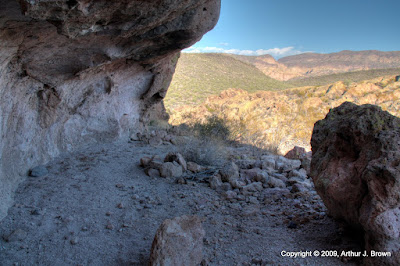
As I was going around the mountain, near an adjacent peak, I was going back and forth in one spot trying to find a way around a small cliff. I didn't want to go above it because that was too dangerous. It didn't look like I could get up the other side if I went below it. As I moved around for different viewpoints I stepped off a large rock on the downhill side. It was a fair drop but shouldn't have been a problem. I guess my joints aren't as sturdy as they used to be, though. There was a twinge in my right knee. I ignored it until I took a step and it hurt again. It wasn't bad, just bad enough to make me limp a little, which is not a good thing on the side of a mountain. It seemed to hurt most going downhill. It seemed silly to go uphill when it was going to hurt coming back down.


Taking pictures, deciding what to do.

By now I had figured out how to get around the bottom of the cliff. I decided to see what it felt like going across. It didn't feel good, so I sat down to take some pictures and decide what to do. It seemed a shame to come so far and then turn back. It would be a bigger shame to have to push that 911 button, though. I looked up. The top didn't look far away, but you can never tell from the side of a mountain. I got out my Magellan. I was 500 feet east of the summit, and 100 feet below it. Much closer than I thought. I stood up and thought about the flannel shirt in the back seat of my truck. I meant to put it in my backpack when the weather cooled off a couple of weeks ago, but kept forgetting. It wouldn't be good to be up here at night without it. I took a few steps uphill. It felt fine. I walked back down. Still fine. I decided to go for the top. The more I walked, the better my knee felt.


The Rolls Off Highway Vehicle Area, as viewed from my rest stop.

The trail continued to a ridge on the north side of the mountain that made a gentle slope up to the top. As I approached the ridge, I could hear the wind that was coming up the other side hissing through the needles of saguaros along the ridge. When I reached the ridge, I felt like I was already at the top. The last few feet were just a technicality.


Saguaro Lake as seen from the ridge on the north side.


Saguaro Lake, with Stewart Mountain behind it, and the cairn at the top. I added a rock.


Canyon Lake is also visible from the summit.


The Superstition Mountains and Weaver's Needle.


Apache Trail winding its way down to Canyon Lake.


Down there is one of my favorite parts of Bulldog Canyon.


The Rolls.

I wandered around on top for a while, taking pictures and enjoying the view in all directions. I got another bottle of water out of my backpack and found a peanut butter food bar while I was in there. Thanks, Lauren! It was getting late and I had to start down. I wanted to get back to the narrow ridge on the south side of the mountain before sunset. I had trouble finding the cairns on the way up. They would be impossible to find in the dark. Oh, BTW, I decided it wouldn't be right for me to name the mountain when I had nothing to do with the trail that led to the peak.


Find the green roof of the scenic overlook pullout!


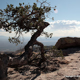
This may be a skeleton by the next time I'm up here.


This is what the trail looks like. Look hard. Use your imagination.


Shadows are getting long.

My knee didn't bother me at all on the way down. Praise the Lord. When I first got on the steep side of the mountain, I lost the trail. Everywhere I looked seemed too steep to descend or cross. I don't think GPS crumbs would help in that situation. If your position is off by 20 or 30 feet, that could be 60 feet in elevation, which is a completely different place. I finally found my way back to the spot where I sat deciding whether or not to go on. There seemed to be several ways down from there, but experience told me that if I didn't go back the way I came, I'd probably be spending the night out in the desert. From that point on the cairns seemed to be easier to find. I only lost the trail twice and it only mattered once. It was just before I got to the narrow ridge. I went back and forth and up and down trying to find the best path back to the ridge. There was a steep drop off between me and the ridge that complicated things. Going below it would be difficult and maybe even impossible, because I couldn't see the whole route. I couldn't remember going above it on the way up but that's probably because I didn't look in that direction. I was looking for cairns, or following the trail. I don't like going above those cliffs because if I fall and slide or roll a little ways, I would go over the cliff. That happened to an experienced hiker in the Superstitions a few months ago. He broke a femur among other bones, but he lived. Anyway, I finally decided the only possible route was above it. As soon as I got over the rise on the other side, I recognized the path to the ridge. A few minutes later the sun sank behind the Goldfield Mountains to the west. I was as good as down, though. The rest of the hike was easy going. I missed a turn once but it was no biggy taking a shortcut to where I was supposed to be. I was back to the truck before I needed a flashlight.

Whew.

Click below to see all of the pictures.

2009_10_11