I knew it was a fair walk to Garden Valley and that I would be stopping to get pictures, so I got to the trailhead at about 2 pm. The sun is very bright that time of day. I risked a burnt bald spot, though, and left my hat in the truck. There were a few vehicles in the parking lot. I didn't see many people on the trail on the way out there. Eight people is not a lot of people to see in and hour and 20 minutes of walking, though it is a lot more than I'm used to seeing while on a hike.

A strange plane that I saw on the way out. Is this the kind of plane John Denver was flying when he fell in the drink?
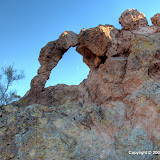
Almost as soon as I started crossing Garden Valley, I looked to my left and spotted the arch. So far, so good. I couldn't tell what was between me and it, other than cholla and mesquite. I walked past the junction where I thought I should turn left, just to see if there were any other trails going in that direction (my backup plan if I couldn't find the arch was to go to the top of Hackberry Mesa). There didn't seem to be any other trails so I headed back to the junction and turned north. The trail I was on now is not official. It isn't on maps of the Superstition wilderness, so I don't know how far it goes and I certainly don't know what kind of terrain it eventually crosses. Going across Garden Valley, though, it is some of the flattest, most desolate terrain I have ever hiked.

See that arch?

That arch.

Vegetation is sparse in this part of Garden Valley.
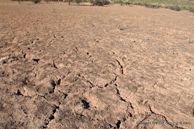
The soil is devoid of rocks (which is unusual out here) and cracks when it dries (also unusual).
It didn't take me very much longer to get to the pile of rocks where I knew the arch was. I wandered around snapping pictures, though, so it did take me a little while to find the arch once I got there.

At the top of a cliff. Can't climb up to it.
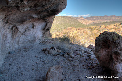
It was at the top of a cliff, so I didn't think I could get any closer. I was close enough, though. I started making my way back down to Garden Valley by a slightly different route. There was a hollowed out area directly under the arch where people had obviously camped. I also found a "cave" formed by a very large chunk of rock that had broken off of the cliff face.
Camper's hideout.

Cave behind a slab of rock.

Thin rock walls at the other end of the slab of rock.

More hollowed out rock.

A hollowed out boulder. Gee, maybe this whole thing is a Hollywood prop.
On the way down, I saw that it would be easy to go back up on the other side of the arch, so I did, of course. On that side I could have climbed up to look through the arch at Weaver's Needle, but the arch didn't look very sturdy. I was afraid to get too close to it.

The moon through the arch.

Fragile looking.

Garden Valley from above.
After I while, I decided I had better head back. I figured I would get back to the trailhead shortly after sunset. As I walked back to the intersection with the regular trails, I came upon a man and woman headed out. The guy stopped me and asked if the trail led to the First Water trailhead. OK, nobody can say guys don't ask for directions any more. Without any prompting, he asked how to get to the trailhead. I told him I was headed that way and we walked together for a while. He and his companion had been out there since 12:30. From his description of where they'd been, they had probably walked at least 10 miles before I met them. I bet they were tired. I'm glad he asked about the trailhead. He might have gotten there the way he was going, but the trails I can see on Google Earth going that way, don't go all the way, and sunset was approaching fast. I had been scolding myself for leaving my flannel shirt in the truck again, but they were wearing shorts. It could have been a long night for them.
Click below to see all of the pictures. There are a lot.
 |
| 2009_10_25 |


No comments:
Post a Comment