The hike starts out on the Boulder Canyon Trail, which leaves from the Canyon Lake Marina parking lot. The trail climbs to the top of a large hill that affords a great view of Canyon Lake and the Superstition Wilderness Area. It slowly descends to the floor of La Barge Canyon as it continues SSE. You then follow La Barge Canyon downstream to where it enters Canyon Lake. Sounds pretty simple.

The Boulder Canyon Trail is through that opening in the white fence.

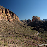
A popular fishing spot as seen from the trail.
Time for a slight digression. Not too long ago (last weekend?), I had hiked out to Garden Valley, and then across Garden Valley to a stone arch. I mentioned that a backup plan was to hike to the top of Hackberry Mesa. On this hike, I looked to the right and realized that I was looking at Hackberry Mesa from the other side. It looks so smooth from this far away, but I'm sure it isn't. Now I'm even more interested in getting up there, though. OK, now back to our regular story.

Hackberry Mesa, with Garden Valley on the other side.
I've been on the Boulder Canyon Trail a few times. The view is great from the top. I had also continued about half a mile beyond the top once, and got some great pictures of an eastern collared lizard there. I looked for more of those lizards on this hike but didn't see any. As I sat near the spot that I had seen the collared lizard, enjoying the view, the second pair of people I was to see on the trail came trotting by. They were abnormally happy. People like that make me nervous. They may be very nice people, but I just don't like to be around them very long, maybe because they conflict with my old grumpiness. We talked for a few seconds. They were making the same loop as me, but in the opposite direction. The guy asked if I was considering turning back instead of continuing. That was clue number one. I wanted to know why he asked that, but their joyful bounciness was more than I could tolerate. I just wanted them to be on their way. Mistake number one.

From here you can see where Canyon Lake goes a little ways up La Barge Canyon. I see a trail over there. That must be where I'll come out. Turns out it was, but not exactly how I thought I would.

Maybe I should have taken the trail to the right instead of the one to the left. I'm going to check out the trail to the right soon. It might be what I was looking for at the end of this hike.

The view from the top.

La Barge Canyon.
Shortly after the humongously happy couple left, I got out my map of the Superstition Wilderness. I found the trail I was on. I found where it crossed La Barge Canyon. There was no trail following La Barge Canyon back to Canyon Lake. Clue number two. I would be off-trail (no guarantees as to being able to follow a route) in a canyon (more about that later). I decided to continue on my quest. Mistake number two.
Let's go quickly to mistake number three. When I got to the floor of the canyon, I realized I had only two bottles of water left. That might not be enough to hike back the way I came. My legs were tired from the climb and descent, so I didn't want to go back that way. It should be mostly level in the canyon. If I ran out of water, I would be getting to the lake soon. I realize now that those were all silly things to think.

Three cairns mark where the Boulder Canyon Trail crosses the floor of La Barge Canyon. They are in this picture. Can you find the trail?
First of all, I was in deep, steep-sided canyon. There were usually enough GPS satellites visible for navigation. Not that I needed any navigational aid. There was no visibility to the communication satellite used by my SPOT. I put the SPOT in tracking mode when I'm hiking. My position is plotted on a map every 10 minutes. Sometimes 1 or 2 updates will be missing because of visibility issues. There was no position update for an hour and twenty minutes while I hiked through that canyon. What that means is that, if I broke a leg, I would not be able to get a "help me" message out. I would have to wait until somebody missed me and hope that they remembered to check my SPOT page to see where I might be and send help before I starved or died of exposure or bled to death internally or something like that.
"But what could happen on that level canyon floor?" you ask. Well, in a word, boulders. In this area, most were baseball size to dog house size, with a few two-car garage sized ones. You have to be very careful where you put your feet because they can roll or slip and you hurt your foot or leg, or fall and hurt something else. I think your chances of being injured are much higher walking on boulders.

Much of the canyon floor is like this; ankle breaking terrain.

Sometimes the vegetation was so thick, I couldn't see where I was putting my feet.

I didn't think I was going to find a way around this puddle.
I came across several stagnant puddles along the way. Nothing from which I dared to drink. I'm going to do some research on water purification so I'll be prepared in the future. I ran out of water a while before I got to the lake, but it was much cooler by then. I really grew to appreciate my Danner boots on that canyon floor. Despite several mishaps on the treacherous footing, my ankles felt secure. Having those boots on that hike was worth every penny I spent on them.
I encountered several different kinds of obstacles in that canyon that took a while to overcome. I spent most of the time on that hike on what I thought would be the easy part. But wait; it isn't over yet.
By the time I got to the lake, it was almost too dark for pictures. I wasn't in a mood to take pictures, anyway. I could see that there was no way I could follow the canyon along the left side of the lake finger. A little exploring showed me there was no way along the right side, either. Now what? Put my clothes, backpack, and camera in a trash back and swim out? If I got in that water, I'd probably die of hypothermia before I found a place I could get out. I seriously thought about pushing the 911 button. Oh, but that would be soooo embarrassing. Then Randy shows up. Randy was fishing from what I thought was a small boat. He offered to give me a ride to a trail. He was very polite for a person that was probably thinking that I was an idiot. It turns out that his boat was more like an inner tube in the shape of a boat. He wore waders and fins and propelled it with his legs. It's a one-man method of transportation. I wrapped my camera in my poncho and put it in the back pack. I sat on the prow with my legs along the sides, facing the rear as did Randy. It was a surprisingly long way to the trail. Randy said he'd never seen the lake that high and that it had risen a few inches while we were talking. Every time he stopped kicking, the prow sank and my butt was in the lake. My boots were also half submerged and eventually leaked. Still, I think it was better than any other options I had at the time. I gave Randy thirty soggy dollars. He said he didn't help me for money, and I know he didn't, but I'm glad he took it without a fuss.
So I stroll into the house almost 2 hours after sunset. My pants are wet from mid-shin down and the back of them is wet from the waist to the knees. Nobody asks why I'm so late. Nobody comments on me being wet. Nobody wonders why I take a shower right away or why I put my hiking clothes in the washer. I think Emily keeps everybody so busy they don't have time to notice all those little things. I'm just glad I found a way out of that canyon.
 |
| 2009_11_01 |


No comments:
Post a Comment