
My destination is back there.

I also wanted to take a look at the old road back here. The peak I'm aiming for is on the right
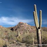
The weather was great and there were wonderful views all around. I think people used to drive out on that old section of road until the forest service fenced it off. There are a lot of cans, bottles, and shot up saguaros out there.

I thought I would be able to climb up the far side of that hill, but it isn't looking very promising from here.
I tried going up the side of the hill nearest me, but it quickly got too steep. I got out of the breeze and sat taking pictures for a while.

Weaver's Needle.

The Superstition Mountains.
Around the other side of the hill, there were some nice views of Bulldog Canyon.

Willow Basin.

I found another arch.
The other day I played around with editing the GPX file for a couple of hikes. I thought I had a way to get rid of the ridiculous spikes in speed that were showing up, but it wouldn't work with the GPX file for this hike. I decided that I need to write a Perl program to make the edits and installed it this morning. Then I discovered that I've forgotten a lot about programming in Perl. I'm sure it'll come back soon. In the mean time, I made hand edits to the GPX file. That took about 20 minutes. The speed graph looks reasonable, though. The data in the file indicates that my data logger wasn't able to navigate for about 84% of the time. I thought I had pretty good visibility of the sky, too. I'm starting to wonder if the data logger just doesn't work worth a hoot in cool weather. I'm going to move it back to the camera strap. Maybe my neck will keep it warm.
Map and pictures are below. Oh, I tried to turn off the picture slide show on the map because computers get bogged down if too many of those are running, but it didn't work. You can pause it, though.
Off trail 102
Map your trip with EveryTrail
 |
| 2009_12_26 |


No comments:
Post a Comment