
I started out going in this direction.
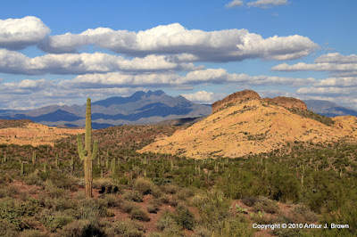
There were some nice fluffy clouds around.

I eventually decided to hike up to the top of that cliff on the left.

A mining claim marker. When I came across this, I felt obligated to empty my pockets of all the gold nuggets I had collected so far. That's OK; they were pulling my pants down.
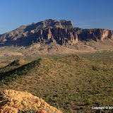
I kind of headed uphill, then cut over to another ridge and headed uphill, and kept doing that until I noticed I was getting close to a cliff. It looked like it would be easy to get to the top of the cliff, and the view was bound to be great from up there. To the cliff, then.

Almost to the cliff (that's it on the left). I took a lot of pictures of the Superstition Mountains on this hike.
There were large animals out there, too. I got close to two of them but never saw them. The first one was in a dense stand of paloverdes. I could hear it walking away. Sounded like a deer. The second one was near where I started walking out onto the cliff. I was slowly walking up to the ridge, snapping pictures along the way, when I heard what sounded like something sliding and then a lot of rocks tumbling. I quietly peeked over the ridge but whatever it was, it was long gone.

That's the top of the cliff on the right.

Not zoomed in on the Superstitions. They look so small.
Panorama of Gold Canyon and Apache Junction.
As I was standing on the cliff, I decided to take a picture of the Superstitions with my phone and send it too a few people. As I was doing that I noticed that there was an update for the Droid EveryTrail app. I downloaded it and decided to use it to make a trip out of my hike back to the truck. One reason I wanted to do that was to see how it handled loss of cell phone service. I was sure that would happen as I descended. It didn't, though. Even though no bars were showing, the map kept getting updated (the map isn't stored in the phone). I'll have to try that experiment again someplace else. The app looks much more sophisticated than it did the first time I tried it out. It seemed to work flawlessly, too. I used the phone camera for the pictures in this trip, so they aren't too hot.
Bulldog Canyon Experiment
EveryTrail - Find the best Hiking near Mesa, Arizona
Click below to see all of the pictures.
 |
| BC_2010_10_23 |


No comments:
Post a Comment