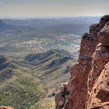
So I drove out past Superior again. It's a beautiful drive from Phoenix to Superior. The road from Superior to where I turned off (Oak Flat Campground) is spectacular. I'll have to take some pictures some time. Anyway, I parked in the same place I did before and walked down to where I thought the trail should be. Lo and behold, there it was.
It would be easy to miss the turn-off for this trail.
At its beginning, the trail was narrow; bushy oaks brushed my shoulders and legs. I didn't have much hope of such a seldom-used trail getting me to my destination.
The entire trail is marked with frequent cairns.
At the beginning, the trail frequently crossed sandy or dusty areas. The only human footprints I saw were mine. It's obviously not a heavily used trail. But there were lots of cairns. I was almost always within view of at least 3. Somebody put a lot of effort into putting those things up. At times they were the only way to tell where the trail went. It was hidden in spots by this past spring's growth.
This area is a lot different than where I'm used to hiking. There are a lot of different plants. I noticed manzanitas with berries on them. Then I noticed poop on the trail with manzanita berries in it. I don't know what animal did that, but I imagined that it was black bears. I know there are a lot of them around Four Peaks, so they may be here, too. I would love to get a picture of a bear. I would hate to surprise a bear. Hikers are advised to make noise as they hike so bears will be aware of their approach. I'm not normally a very noisy guy, but I decided I had better be for a little while Every once in a while I stopped and did my impression of a large dog barking. I've gotten pretty good at it. It fact, a couple of times when I heard my echo, I picked up a rock to bean that mean dog.
The trail was overgrown in lots of places. Also, there were a few times that I wasn't paying attention (imagine that) and lost the trail. The point is, unless you really enjoy bleeding, wear long pants on this trail. There's lots of catclaw acacia. There are a lot of other sharp things, but they pale in comparison to the catclaw. My arms were covered with dried splotches of blood by the end of the hike.

The stock tank I saw on Google Earth.
It's only about a mile hike to Apache Leap. It seemed to take a long time, though. It's about a 1000 foot climb but didn't seem steep at all. It was a very enjoyable hike. BTW, I've hardly seen any gnats since I got back from Texas. They must have starved to death while I was away. It was exciting when I got to the stock tank, because I knew I was very close to the cliff.
After passing the stock tank, I wasn't sure how close to the cliff I was. Then I noticed the wind whipping some agave flower stalks around. I knew I was very close. A couple of more steps and I could see Picketpost Mountain in the distance.

Campers built this wall to shield their fire from the wind.
The wind and the view reminded me of the South Rim of the Chisos Mountains in Big Bend, though not quite as spectacular. The breeze felt great, and the view was very nice.

Unfortunately, I was shooting into the sun.

The Superstition Mountains and Weaver's Needle can be seen on the horizon. Yes, there are more cairns over there.
My pictures do not begin to capture what it was like to be up there. You'll just have to go with me some time. Click below to see all of the pictures.
 |
| 2009_06_07 |


No comments:
Post a Comment