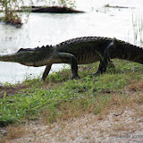
Peggy, Anthony, and I went for a stroll around a couple of small lakes at Brazos Bend State parks, which is about the opposite of a desert (as you will see in the pictures). We walked 4.5 miles and my feet were tired but the only time I breathed hard was to catch up with the other two (I kept stopping to take pictures and they kept walking because a storm was on the way). We didn't get back to the car before it rained, but we didn't get too wet, either. Here's the map and the pictures.
Brazos Bend State Park at EveryTrail
Map created by EveryTrail:GPS Geotagging
I exported the GPS data from the a-trip software after I had geotagged the pictures. As a consequence, the Everytrail map has waypoints on it for every picture (but doesn't have the pictures). Kind of clutters up the map. Live and learn.


No comments:
Post a Comment