
The view at my first stop.
It turns out that the slope is pretty gentle, and the road is in pretty good condition. It is one lane, but wider than most of the roads in Bulldog Canyon. I stopped at the first pullout I came to so I could take a look around. It was already below 100 outside. I followed a pipe I found at the side of the road and it led me to a water trough. There was barely enough water for the bees and wasps, though. It looked like I was already far above the Beeline Highway, but the amount of noise from the sparse traffic was surprisingly loud.

The Beeline Highway snakes south.

The road ahead of me.
I saw three other vehicles on their way up in the first quarter of a mile. It seemed really crowded. I continued up and came to an old stock pen in a grove on pines and alligator junipers. A side road went off to the right. I decided to try it. Now that road is truly one lane. I'm going to have to wax the sides of my truck again to get the scratches from branches out. There was a rock wall on my left and a near vertical drop on my right. The road was very rough. Every one or two tenths of a mile it got wide enough that two vehicles might be able to squeeze past each other. I dreaded meeting somebody coming the other way and having to back up a tenth of a mile on that road. I dreaded having to go around somebody on the cliff side, and wondered if the pines would stop my tumbling. Oh, the things I do for fun. I must be nuts. I wish I had gotten a picture of that road. At one point there was a boulder that had landed about 2 feet into the rock wall side of the road. I inched around it very slowly and carefully. When I came to it on the way back, I tried to move it out of the way. I got it about 4 inches back, which made me feel much better as I went around.
I continued along that road until I got to a wide loop at the only flat spot for miles. I parked there and got out to discover a great view to the south.
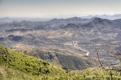
Looking south. Yep, that's the Fountain Hills fountain.
I was still a few hundred feet below the summit. There was a good strong breeze and the temperature was only 84. Unbelievable. To the northwest of my parking spot was Little Mt Ord. It looked like a nice short stroll from where I was, and it turns out it was a climb of only about 133 feet. I was at about 6000 feet, so I didn't need to do a lot of climbing.

Red Mountain in the distance and the Beeline Highway far below. Those buildings are the topless joint at Sunflower.

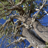
An alligator juniper doing a scene from "Alien".

The Mogollon Rim is still far away, and that fire is still burning.

I took lots of pictures of sticks, but this is about the only one I like.
The sun was still high in the sky, but I didn't wear my hat. I wore it on my hike last weekend and I had a migraine aura (I just get the auras, not the headaches, which is fortunate). As I walked along thinking about it, I realized that I started getting them a lot at work about the time that I started wearing a cap at my desk to keep an overhead light from shining in my eyes. About the time the RIF was over was also about the time that light burned out, and it hasn't been fixed so I don't wear my hat. I think wearing hats is probably what has been causing most of the auras I've had recently. Well, since I can't wear a hat, I guess I'll have to start working on a comb-over. HA!
It was a little strange on that peak. I kept going over to the north side to get pictures of stuff in that direction and then coming back without any pictures. Hmm, low oxygen at 6000 feet. I guess I kept thinking I would eventually find a spot with a view to the north. Anyone that has spent much time in an arid climate knows that the north side of hills and mountains can be covered with trees while the south sides are bare. The south sides get dried out by the constant sunshine but the north sides retain enough moisture for the trees. I couldn't get pictures to the north because of all the trees.
I never encountered any other vehicles on that narrow side road. Thank goodness. When I got back to the main road, I almost continued on up that road. It was late, though, so I decided to save that adventure for another day. In fact, I've got at least two more trips planned in that area. I may make it through the summer without heatstroke after all.
Click below to see all of the pictures. That reminds me about something I've noticed. Recently, Google added the number of times pictures have been viewed to each picture in Google web albums. I have noticed that the pictures I sprinkle through my blog get a lot more views than other pictures in the web album. I don't always put the best pictures in the blog, though. Some people are missing out.
 |
| Mt_Ord_2009_08_09 |


No comments:
Post a Comment