Monday, January 28, 2013

Potsherds?

There seem to be a lot of abandoned Indian dwellings in Arizona, and I often hear people talking about finding pottery or arrowheads out in the desert. I've never run across anything like that myself, though. Maybe it's because I don't know what to look for, though you would think that after looking at millions of rocks I might notice if something didn't look quite like a rock should look.

A guy I work with showed me on a map where he had found some pottery fragments once. I went out there to take a look. I found about a dozen small pieces of what I'm guessing used to be pottery.


Is this a potsherd?


Edge view of one piece.

I hear that you aren't supposed to disturb any such artifacts, much less take them. I only touched two pieces. Well, how do you know it isn't a rock until you look at it? I carefully put those two back the way I found them. I've decided that I won't reveal the location on the slim chance that somebody reads my blog and also that that somebody likes to pilfer Native American artifacts.

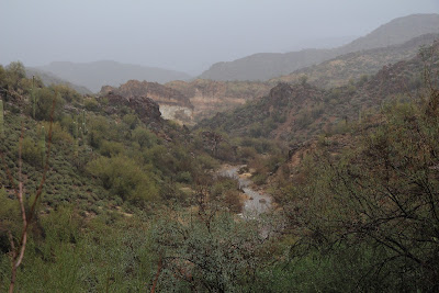
It was a beautiful day when I was out there. I got some nice landscape pictures. They would gives hints about the location, though, so you'll never see them here. I did include some pictures of a rock outcropping, but there are cairns in the area so anybody that gets close enough to recognize the rock pictures was probably going to that spot anyway and knows what is there. Click below to see some more of the pictures.

2013_01_13

Sunday, January 27, 2013

Willow Creek waterfall

About a year ago, I had taken some pictures of waterfalls near Willow Creek, which is just east of Canyon Lake. I didn't have a tripod with me and so I was disappointed in how the pictures turned out. I wondered if I would ever have the opportunity to get pictures of those waterfalls again.

It started raining on Thursday. I heard rain every time I woke up Friday night. The fake river in our back yard was flooded on Saturday morning. I decided it was time to get some waterfall pictures and headed for Willow Creek. It was still sprinkling. I couldn't find a poncho but I did take an umbrella. I figured I would need to hold it over the camera while taking pictures. Turns out it was raining hard enough that I used it the whole time I was out there. Too bad I don't have a video of myself trying to get through palo verdes with that umbrella. I'm sure it would be entertaining.


Light rain, but I'm determined to get some pictures. A short time after I took this picture I realized that the tripod was still in the truck. Well, at least I found a way around the mud on the way back.

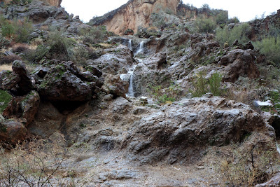
As soon as I started down the trail, I could see water flowing in the stream that would eventually become the waterfall. Other streams joined it along the way. When I started the descent to Willow Creek, I could hear a pretty loud roar coming from Willow Creek.


Water flowing in Willow Creek. Taking pictures while trying to keep an umbrella over the camera is not easy. I eventually tried sticking the handle in my pants and that mostly worked.


First picture of a waterfall.

I had the polarizing filter on the lens and it was gloomy enough that I could get long exposures without using a neutral density filter, which is a good thing since I have decided they are too pricey for me and I'm too lazy to carry them around and put them on anyway. Most of the pictures were made with a 1 second exposure. My tripod is really wobbly so I had to use a 10 second delay to give the camera time to quit shaking after pushing the shutter release. Every now and then the wind would pick up and I didn't realize until later that it blew tiny drops of water around the umbrella and onto the filter.


Water drops on the filter.

The only thing I had that I could use to wipe off the drops was the flannel shirt that I was wearing. It was a little damp from walking past trees and bushes, but it worked.

I took lots of pictures down near Willow Creek, but what I thought would be the best part of the waterfall was up higher and couldn't be seen from where I was. I had tried climbing the opposite bank to get a view of it before but that was a lot of work and I never did get a good view. The only think to do was to try to get a view of it from up top, on the west side of the waterfall.


The best part of the waterfall is out of view, above and to the left of this. I need to be on that cliff at the top of the picture.

I had to get on the edge of the cliff to have a view of the waterfall. I don't like being on cliff edges. Especially cliff edges coated with soil loosened by rain. I moved very slowly. Fortunately, the wind didn't blow while I was up there.


I estimate that this is a 20 foot drop.


I also made a short video. Sounds cool.

Click below for all of the pictures.

2013_01_26

Saturday, January 12, 2013

An oven, and horses

No, the horses don't have anything to do with the oven, except that they just happened to be in the same area.

I was surfing the web a few weeks ago and along one of the random rabbit trails I was following, I found a description of a hike near Saguaro Lake. It describe an oven built into the side of a cliff and had one so-so picture of it. About the only clue to its location was that the description said it may have been made by people driving sheep along a trail between summer and winter pastures. Well, the hike description described the loop they took, but I have trouble following verbal descriptions. I couldn't tell from the description whether the oven was on the Saguaro Lake side of the loop or the opposite side of the loop. I do know approximately where the sheep trail is, though.

It took two attempts to find the oven. The first attempt was on a weekday after work. I didn't have much sunlight. In fact, the sun had set several minutes before I started up the wash where the oven is located.


A trail follows the right bank of the Salt River to the wash. The trail is often used by fishermen.


The sun set while I was still following the trail along the river.

There's a parking lot at the trailhead, but it costs about $6 to park there. Being as cheap as I am, I parked over half a mile away at the Blue Point entrance to Bulldog Canyon.

On that first hike, I went up the wash until it got too dark to take pictures of anything but the sunset. No sense in finding the oven if I couldn't take pictures of it.


There are lots of footprints here. I think many of them are human, but there are also many horse hoof prints.

Well, obviously I didn't find the oven on that first hike. I didn't expect to. I mainly wanted to check out the trail along the river. I didn't even know it existed until I read that hike description.

I finally made it back out there a couple of weeks later. It was overcast and gloomy. Not good for landscape pictures, but I was looking for an oven.


See how gloomy it is? This would be a much better picture with sunshine.

Since I wasn't racing nightfall on the second hike, I walked a lot slower. I didn't have any idea how close to the wash the oven was, so I was looking for anything that might lead to something away from the wash. At one point I did spot some suspicious piles of rocks and climbed around for a while trying to find out why they were there.


There are at least two suspicious piles of rocks in this picture. One of them is hard to see. I didn't see the easy one until I looked at this picture, though.

I couldn't find anything besides cairns up there, and after a short while I couldn't find any more of them. I don't know if they lead to anything. I wonder if they might just be there to get people to a good spot to view an unusual saguaro. I have the feeling there might be something else up there, though. I need to go look again.


This saguaro is kinda funky looking.

The clouds started moving off to the east after a while. That's about the time I saw a pile of white rocks on the side of the wash. I was getting ready to take a picture of them when I spotted the oven behind them.


My first view of the oven.


A better view of the oven. You can see that it is built into the cliff.


The top of the oven.

While I was on the hill above the oven, I noticed a couple of wild horses across the wash. About the only place I've seen them before is along the Salt River. I've never seen them while hiking away from the river, but I see their hoof prints miles from the river. After I got a few landscape pictures I decided to see if I could get close enough to the horses to get some pictures. As I walked slowly and quietly up the other bank, I could see well-worn horse trails. It looks like they hang out in that area a lot. I didn't find the two I had seen earlier, but I did find six others. They didn't seem to mind my presence much. They even ambled past me like I was just another palo-verde. They also ignored my camera and didn't give me any striking poses.


A couple of the horses. They eyed me suspiciously and then walked by within 15 feet of me.


This horse seemed wary of me. It kept an eye on me the whole time.


I took lots of pictures of the horses. Most are of horses behind creosote bushes.

By the time I was done taking pictures of the horses, they sun was out. I re-took some of my other pictures now that the sun was out.


This saguaro looks much better with blue sky behind it.


I took more pictures of the river now that the sun was shining.


When I first saw these horses, I wondered if it was the ones I was taking pictures of earlier and they had run down to the river along a different route and were standing there like, "What took you so long, human?" Smart aleck horses ;-)


That's pretty.


Doesn't this look better than that gloomy picture?

As I approached the highway, I saw several people on the river bank with metal detectors. I talked to one guy and he said they find earrings, rings, watches, knives, etc. in the river bed (the water level is dropped in the winter). That doesn't surprise me, considering how drunk most of those people are.

The pictures are in two web albums.

2012_12_19

2013_01_06

Wednesday, January 09, 2013

The other end of a canyon

A few weeks ago, I had hiked up a canyon near Hewitt Canyon Road. It got too rocky for me before I got to the other end. I decided to see how far I could get when starting from the other end of the canyon. Of course, I would have to do some climbing to get to that end of the canyon. I started out going up a wash that went around the southwest side of Byous Butte.


In the wash. It's kind of rough and there's lots of plants on the sides.

I checked out the terrain carefully on Google Earth before I left the house, so I had a pretty good idea of my intended route. From inside a wash, though, it can be difficult to know if you are where you think you are. I waited until I thought I was in the right place before leaving the wash and as I suspected it would be, it was quite a struggle to get out of there. Lots of dense vegetation, and some of it grabs you.


There's a nice view of Apache Leap on the way up.

I came across an old ATV trail shortly after leaving the wash. It looked like there probably hadn't been any traffic on it for at least a year. It was much easier walking there so I followed it for as far as I could.


Old ATV trail. Hopefully, it won't be used any more.


Looking at this, I thought I was almost at the ridge that separated the two drainages. Turns out I had a lot more climbing to do.

By the time I got to the ridge at the end of the canyon, I was too tired to go into it. It didn't look very interesting from this end, anyway. I decided to take a chance and take a different route back. I could tell that if I had to do any back-tracking, it wouldn't be for very far.


The target canyon.

I followed a ridge out to a pointy hill. The sides were almost uncomfortably steep. Almost. It looked like it got steeper toward the bottom in the direction I wanted to go. I couldn't remember seeing anything like that on the way up, though. Also, nearby hills weren't dangerously steep, so I started down.


Side view of the hill I would be descending. Doesn't look bad from here.


The shadow of the hill I'll be descending. I thought this looked cool. I've read the near sunset, the shadows of all large mountains look sort of like this, no matter what the actual shape of the mountain is. I'm not on a large mountain, though, and it's still a while until sunset. It's really shaped like this.

I spotted another old ATV trail as I descended and followed it along the desert floor. Walking was pretty easy until I had to cross the wash. If there are even any deer, sheep, or cow trails through all that vegetation, they must be few and far between.


The sun was at a better angle for pictures of Byous Butte by the time I got back to the truck.

Click below to see all of the pictures.

2013_01_04