Wednesday, December 18, 2013

A different view of Canyon Lake

I've always wanted to see what Canyon Lake looks like further upstream. I looked into renting a boat but that is outrageously expensive. I think about buying a kayak but I worry that the lake might be much larger from the perspective of a kayaker. Then there's the obvious solution; hike. I've looked at that area on maps and Google Earth, and there's even what looks like a road going where I want to go. I've hiked along that road two or three times but always turned back before I got very far because of heat, approaching darkness, or gnats. Well, this is another one of those "while I can" hikes, and the weather is perfect this time of year, so off I went.


It still hasn't dried up completely since the last rain.


I always take lots of pictures of this mountain when I'm in this area.

I figured I would follow the road as far as it went, and then see if I could get to the top of a nearby hill that should overlook that part of the lake. It turns out that it really is a road. At least I think it might be. It's very lightly traveled. It had one set of recent tire tracks when I was out there. They were so fresh, I thought I might find a truck at the end of the road.


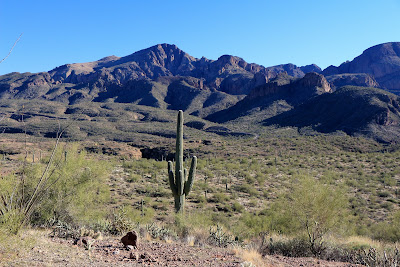
Here's a saguaro and that mountain.

Before I even got to the end of the road, I started to worry about how late it was getting. I couldn't turn back, though. I had flashlights I could use on the way back if I had to. When I got to the end of the road I could see that it would be easy to get to the top of the hill that was my destination. As I was going up the hill (a gentle slope with only minor obstructions), I came across a freshly chewed prickly pear pad. I figured that meant that there were javelinas nearby. A few steps later I was walking around a prickly pear when a dead paloverde branch tried to push me into the prickly pear. I pushed back and the branch snapped with a loud crack. That set off the javelinas that had been standing quietly about 100 feet from me. They snorted and stomped and snorted and stomped away down a ravine. All but one, that is, and it hung around a few seconds so I could get a picture. Grunting javelinas sound a lot like guys in their 20's that are trying to sound like cave men. The next time I see some I think I'll grunt like they do and see what happens. Some javelinas, that is. Hmm, maybe they'll feel challenged and charge me.


Javelina wondering what all the fuss is about.

I went up the side of the hill that didn't have a view of the lake, but the view was impressive. I was distracted by it for a while before I got over the top of the hill.


A nice view before I reached my destination.

At last I got to the top of the hill and the view of the lake was as impressive as I had imagined it might be for the past 5 years.


A view of Canyon Lake that few people see. No, boaters don't see it, because they don't climb this hill.


The view is also very impressive to the north of the lake.


The road.

I wanted to hurry on the way back. The sun officially set about 20 minutes before I got back to the truck. I couldn't hurry much, though. I've slipped a couple of times in the past on that road. By the time I got to the steep downhill parts during this hike my legs were pretty tired, so I was moving kind of slow. It was 4.9 miles round trip, with about 1200 feet of ups and downs. The views were well worth the hike but next time I might see if I can drive on that road. Click below for all of the pictures.

2013_12_14

Wednesday, December 11, 2013

Black Cross Butte

This is another one of those hikes that I've been meaning to make for quite some time but have decided I had better get it done before I fall apart. I think I searched the web for a route to the top long ago and the only description I found talked about climbing (hands and feet) and hopping along the tops of hoodoos. Well that's just crazy. Then a year or so ago somebody told me about an easy route to the top. He was on his way up there with his whole family, including little kids. Google Earth is high resolution in that area now, and I can even see the trail on there. It isn't an official trail, but it'll do.


We started the hike with a stop at the tall skinny rock. Well, this is a family-friendly blog.

My older sister's husband went with me. They've been in western New Mexico the past few months and have done a lot of hiking out there. I was afraid I would be slowing him down but it didn't work out that way.


I took this picture because of the reflection off the water but then I noticed the rock on the right that looks like it's winking at you.

For some reason, I always think of the first part of this trail as being almost level with a few ups and downs. You climb 400 feet on the first part but probably go up and down 700 feet in the process. I'm always tired after hiking out there and blame it on distance, but I think it's really all the ups and downs.


Looking across to the hill I climbed back on November 17.

About 0.8 mile into the hike, Willie declared that his legs were tired enough. He's used to hiking with Julia, and she gives him many more opportunities to rest than I did. He told me I could go on if I wanted to and he would meet me back at the truck. Well, at first it seemed rude to go off and leave my tired guest alone out in the middle of nowhere. But he sounded sincere, and he's a hunter that has spent many days alone in the wilderness. I knew he wouldn't have any qualms about being left alone and would actually probably enjoy some solitude. I also knew I didn't have to worry about him getting lost or climbing something he couldn't get down from or falling off a cliff. Of all the people I know, he's probably the most capable person to leave alone someplace that he's never been before. So I did.


It's surprising to me that this shows up so well on Google Earth.

The rest of the route to the top was all climbing, but it wasn't difficult even though it was another 400 feet up from where I left Willie. The view was as good from the top as I had suspected it would be.


This was taken from somewhere in the middle of the top. I had to go to the edges for the really good views.


Is this THE black cross of Black Cross Butte? This actually shows up on Google Earth. I didn't notice what looks like the grassy outline of a building foundation until I was home looking at pictures. I may have to go back.

I spent less than half an hour on top. The temperature was below 50 and the wind was blowing 10 to 15 mph. I had to keep moving or I would freeze. Hey, I'm used to 105. 50 is colder than I like. It's hard to keep moving fast enough to stay warm on almost level ground covered with ankle twisting rocks and shin stabbing agave and evil prickly pear. I did bump into a prickly pear up there, but I was able to remove all the thorns without taking off any clothing first.


A lot of the butte looks like this, which is why I thought it would be difficult to get up here.


Here's a picture looking down at where the truck is parked. I'm only about 700 feet above it.

I made several panoramas from the top. They aren't in the web album. I put them on my Panoramio page. All but one are full resolution, so you can zoom in quite a bit.

I had my hiking stick with me on this hike, and was glad I did on the steep down parts of the return hike. I was very tired by the time I got back to the truck (where Willie was waiting patiently). I pulled the GPS out of my backpack and was shocked to see that I had hiked only 3 miles.


This is Teddy Bear cholla. I guess it's called that because it looks so cuddly. When viewed under a microscope, the spines can be seen to be made of backward facing scales, kind of like fish scales. They go into skin easily but are difficult to pull out.

I had started the day on my feet for a couple of hours. I was a little hesitant to go on this hike after that, but the sun was shining. This time of year, it could be gloomy and overcast by the next day, so I went. It was difficult to walk the next day but worth it. Click below for most of the pictures.

2013_12_07