
There seems to be a lot of Christmas cholla near the road.
I met a couple of guys on horseback at the beginning of the hike. I thought they might be familiar with the area and asked them if they knew anything about the two canyons. Turns out they had just been wandering around out there for the first time themselves. I told them what direction I was headed and they said I shouldn't go that way because it's very rocky. Well, if you're going to hike up a canyon out there, it's going to be rocky.

I'm going in this direction.
A short time later I came across a couple of guys that looked like Duck Dynasty cast members. I wish I had gotten a picture of them. We talked for a while about what might be out there. Turns out that was there first time out there and they didn't know anything about the area.
This canyon also had cairns every now and then. I have decided that's just somebody's idea of a joke.
I got an earlier start and so I got further than I did last weekend. The rechargable batteries I use in my PN-40 are giving out so I've been trying to use either the EveryTrail app or the Endomondo app lately. I used EveryTrail last weekend. Since I didn't have a signal when I finished the hike, I selected "upload later". I've tried several times to upload the track since then and always get an error message that says the internet connection is down. It isn't. I wrote to their tech support. No response yet. So not only can I not transfer pictures from my web albums to EveryTrail trips, I can't even upload trips now. EveryTrail seems to be going downhill. Endomondo isn't much better. It seems that if you do anything with your phone besides run the Endomondo app (e.g., read a text message), the app does unpredictable things like deciding your hike is complete, or not collecting any data for the next hour. I need to buy some more batteries for the PN-40 because it looks like all the smart phone apps are probably useless. The PN-40 only crashes once a year or so.
I checked my SPOT page when I got home yesterday. The canyon didn't seem to be that narrow, but There was over 1.5 hours between a couple of updates. Should be updates every ten minutes. Nobody that I depend on to watch that and send help if I'm incapacitated seemed to notice, though. Maybe they're just confident that I won't be doing anything stupid.

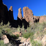
It was pretty in the canyon. There were lots of interesting formations. I took a lot of pictures but pictures taken from the bottom of a canyon just don't look very good.

The further upstream I went, the bigger the boulders in the creek bed got.
It was very quiet in the canyon. Every once in a while a cool breeze would blow through it, and it felt wonderful.

The GPS track from my PN-40 tells a story. On the way up the canyon, you can see that I stopped a lot to take pictures. You can also see that I kept going slower. That's because the boulders were getting bigger and progress was more difficult. My speed slowly picked up on the way back. I wasn't stopping to take as many pictures on the way back, but I realized that I needed to stop and rest now and then or I would stumble around because my legs were tired. I only climbed 500 or 600 feet but I did it by going up 2.1 feet, down 2 feet, up 5 feet, down 4.8 feet, etc. My top speed on the road back to the truck was lower that when I started out. I was tired.
Click below to see all of the pictures.
 |
| 2012_12_08 |


No comments:
Post a Comment