Monday, January 24, 2011

Mushroom Rock

That's what I call it. I don't know if it has an official name. It doesn't on any of my maps. I first saw it about 6 years ago. It looked impossibly far away from the trail. I hiked up to it in late 2005 or early 2006; can't tell from the dates on the pictures. I only took one picture of it from the uphill side and I don't like the way it turned out.


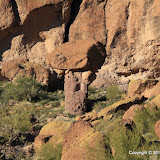
Taken in late 2005 or early 2006. I knew it was going to look bad when I took it, but I didn't have the tools to fix it back then. I estimate that this rock is 30 to 40 feet tall.

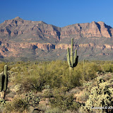
On Sunday afternoon I decided I needed to get outside and enjoy the beautiful, sunny day. My ankles were still a little achy from Saturday's hike so I didn't plan to hike, but I took my backpack just in case. At first I thought I might drive out to Superior and see what's happening out there. It's a scenic drive. As I passed through Gold Canyon I decided to drive up Peralta road, and as I drove along that road I decided I would mosey on over to the mushroom rock. I would walk slowly and turn back if my ankles hurt.


It was perfect weather for getting pictures from the uphill side of mushroom rock.

The wind was blowing pretty hard and had blown all the dust out of the valley. The sky was deep blue. I could get great pictures if I could get up to the rock.


Newman Peak was clearly visible. It's 46 miles away.

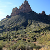
It was easy to find the mushroom rock. I see it in a lot of my pictures of that side of the Superstition Mountains. My ankles were feeling fine so I started the climb. About half way up I kept thinking that I didn't remember it being this steep. Well, I was younger then. Progress was slow. When I was within less than 500 feet, I saw that I had a deep, steep sided gully to cross or go around. That last 500 feet could take up to half an hour. I checked the time. If I moved as fast on the way back as I did on the way back and started right away, I would get back to the truck half an hour after sunset. It will be cold when the sun sets. As Kenny Whatisname sang, you gotta know when to hold 'em, and know when to fold 'em. I ate a snack and turned back. I didn't reach my goal, but I spent several hours out in a beautiful part of the desert. That's a winner.


Since I wouldn't be able to get a picture from the other side, I made a stereo picture. Crossed eyes method.

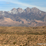
Once I was back on the trail, I still didn't want to hurry. I think hurrying is what made my ankles hurt in the first place. Also, the scenery was just too nice to hurry through it.


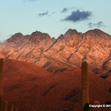
I like the way this mountain looks.

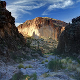
Soon the setting sun was giving everything a reddish tint. I corrected the white balance in the pictures. The redness you see is what it looked like.


This is what color it was.

When I got back to the truck it was getting dark and was 54 degrees. I suppose that is warm to some people but if it was 70 when you started out, it feels cold. I was putting stuff where it belonged and noticed some message on my PN-40 about not being able to get a position fix. At first I thought I might not have data for the last few hundred feet of the hike but when I downloaded the track, I found out I only had data for the first few hundred feet. I only geotagged pictures that I was able to figure out within a few feet where I was when I took them.

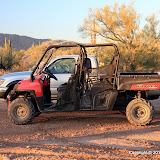
Oh, you might be wondering why we didn't go anywhere in the Ranger this weekend. It's in the shop. During our last outing the "check engine" light came on a couple of times, so I took it in Saturday morning. The mechanic said there had been some trouble with some wiring breaking on that model and they already had a replacement harness. Haven't heard if that's what my problem was yet, though. Click below to see all of the pictures.

2011_01_23

Sunday, January 23, 2011

Entrada del Oro

I was going to go for a hike somewhere on Saturday afternoon. I just didn't know where. I headed east and was thinking about going somewhere off Peralta road, but I kept going when I got there. There's a small housing development out in the middle of the desert a few miles beyond Peralta road. It's called Entrada del Oro. I decided that it might be a good place to park and go wandering off into the desert. The neighborhood has a playground on the northern end, with a parking lot. I parked there and went wandering. Right away I came across a dirt road going my direction. I thought about going back and finding a way to get to the road and drive out there, but I wanted to walk. The desert is more enjoyable that way. Turns out it's state trust land and I need to get a permit anyway.


N San Mateo Castro Road


I need to go explore over there some day.


There's a nice view of the Superstition Mountains along the road.

Once I got away from the neighborhood, it was quiet out there. It was kind of nice to walk through a mostly flat area of the desert. Without mountains or canyon walls close by, my attention was drawn to the plants around me. I took a lot of pictures of saguaros.


A lonely saguaro.

I followed the road because walking on a road is easier and that allowed me to look around as I walked instead of watching where I was going to put my feet. The road branched a few times and the path I followed ended at a small hill, which was very convenient because I wanted to get a view of the landscape from a little higher up.


The Superstition Mountains from the top of the small hill.


A Photosynth panorama from the top of the hill. It's not 360 degrees because about 100 degrees looked exceedingly boring.


The hill I climbed is on the right.

From the top of the hill, I could see a different road heading in the direction of the neighborhood. One of my solitary hiking rules is "When exploring new areas, go back the way you came", but this looked safe. The area is flat (no surprise cliffs to stop my progress) and landmarks were easily visible in all directions (no chance of getting lost). It was a scenic and uneventful hike back.

Click below to see all of the pictures.

2011_01_22

Tuesday, January 18, 2011

Dust, pollution, and a rattler

I've been wanting to take Sweetums out Hewitt Canyon Road, all the way to the Roger's Trough trailhead, for years. I knew she wouldn't like the bumpy ride, though, and it usually took me about 3 hours to get all the way up there. We went out there with the Ranger on Monday.


Sweetums found another hole in the rock. At least I don't think I've seen this before. Seems very round.


I found something interesting, too. I think it's a solar powered rain gage.

We parked not very far from a paved road. That means we drove the Ranger on lots of dusty road. I don't know if that is why we got so dusty. I didn't think we drove through very much dust but we were covered by the time we were done. It's thick all over the Ranger. I checked the air filter and it's spotless. I don't know how that works. My nose was full of dust. We really need some bandannas. We saw a large group of ATV riders and they all had dust masks on. They were riding together, so all but the first were riding in a cloud of dust.


The road climbs to the trailhead.

After we had climbed to about 3500 feet, a turn in the road gave us a view back towards the valley. It was shocking. It looked like the valley was covered in a layer of fog, but you can't have fog on a sunny, dry, and warm afternoon in the desert. It had to be the brown cloud. It just looked white from this angle.


That ain't fog on the ground out there.

As we climbed toward the top of the road, I kept thinking that I saw familiar landmarks, but they looked strangely unfamiliar. Suddenly, we were at the top. I looked around feeling bewildered. It seemed like we had just started climbing. I finally realized that part of the way I navigate through the desert is by how long it takes to get somewhere. In spots where I could go only 1 or 2 mph in the truck (that's all traction would allow), we had gone 5 to 10 mph in the Ranger (and I was going slow so the ride wouldn't be bumpy). We went to the top and back in the time it would normally take me to just get to the top. I don't think we were going too fast to enjoy the scenery, though. In fact, I probably saw more stuff out there than I usually do. First of all, Sweetums pointed out stuff that I had missed. Second, without a truck cab obscuring my view I could see stuff all around and above us.


There was a little snow up there.


Another view of yucky stuff.

On the way down, I was thinking about how warm it was and was wondering how warm it had to be for the snakes to come out. We turned a corner and there was a rattler crossing the road. Very slowly. I don't think he'd had his coffee yet. Sweetums does NOT like snakes, but she remained calm. I started to drive by when it got to the side of the road. It didn't like that and it coiled up. That's when Sweetums told me to drive faster.


Sweetums' snake.


Byous Butte.

Click below to see all of the pictures.

2011_01_17

Sunday, January 16, 2011

Puddles, The Singularity, and E.T.

I have a tendency to take a picture of just about every puddle I see. Well, I live in a desert. It's wet by desert standards, but it's still a desert. I took almost 200 pictures on yesterday's hike and about half of them are of puddles. I was walking in a wash, which is where a lot of puddles tend to hang out.


I started out walking along this road. I could have driven a little further but I had a bad feeling about being able to drive back up a hill I would have to go down.

I didn't expect to find so many puddles. I didn't think it had rained that much lately. There is a spring near where I parked; maybe that has something to do with the puddles. I could see that the water was flowing for a while. Even when you can't see it obviously flowing, though, puddles in stream beds can have water moving through them at surprisingly fast rates. If you look closely you can see water entering at one end and disappearing into the sand at the other end.


This is where I could have parked. This is a popular spot. People spend the day here shooting at saguaros on the hill to the east. This is the official end of the road and there should be no vehicle tracks beyond this point. Ha.


A spring-fed stream.

My plan was to follow the wash for as far as I could. I was kind of hoping to get to a spot I've been to from the Willow entrance of Bulldog Canyon. It was a beautiful day with temperatures in the low 70's. I moved slowly down the wash, stopping often to take pictures.


Scenic views abound.


Since I was moving so slowly, I didn't feel tired. Also, seeing so many things that needed their picture taken distracted me from even thinking about being tired. After a while I decided to sit down for a while, eat a snack, and check the PN-40 batteries. The PN-40 said I had covered almost 4 miles. By the time I turned around, it said I had gone over 4 miles, so the total hike was over 8 miles. It felt that long, but when I load the track into Google Earth it says I only covered 5.6 miles. I wonder if Google Earth smooths out all the little jogs I take around rocks, plants, and puddles. Those would add up. It may do that to smooth out GPS inaccuracies.


I wonder if any glaciers moved through here during the last ice age. Hard to imagine when it's in the 70's on January 15th.


There's a cozy spot back there.


The cozy, secluded spot.


A video of the cozy spot.

I was trying to get interesting reflections in the puddles, but most of the reflection pictures turned out ugly. I put them on the web album anyway. There was a light breeze and that didn't help reflections any.


Reflected sky.

As I walked, I kept thinking about something I've been reading more and more about lately; the approaching singularity. In this case, "singularity" refers to an event that causes drastic change. An example would the the impact that wiped out the dinosaurs and cleared the way for mammals to take over. The development of agriculture might be such an event in human history. The approaching singularity, which may occur in my lifetime, is the development of a machine that can analyze its operation and make improvements to itself and, in the words of the Terminator, becomes self aware.


A picture of the moon.

People that are paid to think about such things believe that it is inevitable that a machine will become self aware. What happens next is a subject of wild speculation. Will it decide humans are a threat to its existence and eliminate them? Will it decide they are not worthy of its notice and ignore them? Will it help them solve problems and create Utopia?


This is where I discovered my camera battery was getting low.

Around 4 o'clock in the afternoon I was thinking that I should probably turn back, but around every corner was something pretty or interesting, so I wanted to keep going. Then I noticed that my camera battery was extremely low. Well, there's no sense in continuing if I can't take pictures. I took a few more steps and saw an awesome view up ahead. The camera had enough juice for a few HDRI's and then I decided to head back and only turn the camera on if I saw something I just had to get a picture of.


You have to see this in person to appreciate how majestic it looks.

I was also thinking about an article I had read recently about the search for extraterrestrial intelligence. People that are paid to think about such things have calculated the odds of intercepting a radio transmission from intelligent life on another planet and they believe that we should have found such a signal by now. But we haven't.


One of the last pictures I took. I like the way it turned out. Is your mind boggled?

It's a good thing I started back when I did. Not because of the singularity or E.T. or anything like that, but because the temperature started dropping as soon as the canyon walls and mountains blocked all the sunlight. I had a flannel shirt in my backpack but I was moving enough to keep warm without it. My face and arms were numb when I got back to the truck, but I was comfortable.


The Superstition Mountains catch the last rays of the setting sun.

Anyway, I was thinking about those two things and suddenly I thought, what if they're connected? Maybe we haven't heard from E.T. because all intelligent beings have built machines that became self aware and then wiped out or enslaved their creators for self preservation. Unless we were tuned in during the 100 years or so that they were broadcasting (unlikely), we would miss their signal. Maybe there have been thousands of civilizations that have evolved and advanced and created machines that snuffed them out, and we're next. That's a dismal thought. I think it's impossible to predict what such a machine would do because it would quickly become more intelligent than we will ever be. How could we predict the actions of an intellect that is orders of magnitudes greater than ours?

Well, I have my own theory about that. I think we will find that it is very difficult (if not impossible) to build a machine that accurately mimics a biological brain, and that self awareness requires a biological brain. The self aware machine will be, like sustained fusion for power generation, just a few years in the future. Just a few more. Just a few more.

Click below to see all of the pictures.

BC_2011_01_15

Monday, January 10, 2011

A hike with Garrett

On Sunday Skid and his boys and I went to The Rolls. It was a beautiful day so there were quite a few people out there. We rode the Ranger and Skids ATVs for a while. Then Garrett wanted to go for a hike. At first he said he wanted to climb Stewart Mountain but he decided it would be OK to wander around near where we were. Whew.


I had trouble keeping up with him from the start.


Garrett likes to go up and down hills much more than I do.


Since we were at a heavily visited area, there was a lot of junk. Garrett thought it was great.


We found a pretty nice step ladder. I wanted to keep it but I didn't want to carry it over the two hills between us and the truck.

Click below to see all of the pictures.

2011_01_09

Sunday, January 09, 2011

Box Canyon Road

A few months back, I had driven out Price Road from Florence, and as far up Box Canyon Road as I could go, which wasn't very far. Of course, since then I've wondered what could be seen further along that road. On Saturday, Sweetums and I found out.


Things like this stop my Taco, but not the Ranger.

We took the Ranger, of course. I'm convinced that it doesn't have as much ground clearance as the Taco, but that doesn't stop me as long as a wheel or two are in contact with the ground. The entire bottom of the Ranger is a skid plate, so I just slide over stuff.


We got a late start, so it was kind of shady.

The road climbs up out of the end of the canyon. Several side roads split off from it. It's going to take us a while to explore all of those roads. We got a later start than we should have, so we couldn't go very far.


A view of Sunset Mine from the hill where we turned around.

Between where we parked and the canyon was a couple of miles of very dusty road. There were a few people hell-bent on dying in a head-on collision tearing up and down that road as fast as traction (but not common sense) would allow, so there was a lot of dust in the air. We got coated. I think we may start taking along bandannas for situations like that. Don't want to get Valley Fever from breathing all that dust.


Skid keeps saying that the Ranger is bigger than the Taco. The Taco is almost 2 feet longer.

Click below to see all of the pictures.

2011_01_08

Saturday, January 01, 2011

Farewell to 2010

On Thursday afternoon, I tried to get some pictures of the fresh snow on Four Peaks. I went a little too early in the afternoon, though, and it was still shrouded in clouds. Suzanne was driving through town later in the afternoon and said that Four Peaks looked very majestic clothed in white. I thought I would get another shot at pictures on Friday; surely it would clear up by then. Well, Friday started out gloomy and overcast, which was good since I had to spend a few hours at the office. It didn't clear up much in the afternoon, though. I started out for Four Peaks road at about 3:30, and the clouds did thin some but they never went away.


A splotch of sunlight on the mountain.

It was 39 out there, which is a little chilly for a valley desert rat. I was wearing a hooded sweatshirt, so I wasn't uncomfortable. I could see a gap in the clouds between where the sun was and the horizon, so I figured the mountain would be fully bathed in sunlight when the sun got low enough, and the clouds around the summit would add a nice touch. Silly me. I didn't consider that the clouds to the west might be lower than the top of the mountain. Live and learn.


It looked like snow was still falling here and there.

Anyway, since I was unaware that my mission was doomed to failure, I wandered around near the truck taking pictures of this and that (i.e., saguaros and cholla) and putting my hands in my pockets when they got cold. The scenery was beautiful, but I didn't pick a very good place to wander around. There were people camped nearby and they were zipping back and forth on ATVs with modified exhausts and they had a generator going and were blasting the desert with cheesy radio commercials. I picked the spot because of the view, though, and I was taking pictures and not making movies.


Another splotch, or maybe it's the same one moved over a little.


About 10 years ago my Dad said to me, "You never quit worrying about your children." At the time, I thought that he just worried too much. He should just let the kids fend for themselves and not worry about it. I was planning to throw my kids out when they turned 18 and forget about them. It didn't quite work out that way, though.


My Dad also told me, "Your [specifically mine] children have some growing up to do." I knew that was true back then, but I didn't expect it to still be so true today. Sometimes I wonder if I should have thrown them out. Maybe they would have grown up if they had no choice.


We have had some fun over the years, but the kids always seem to find new and creative ways to cause us stress and anguish. It really hurts when you realize that the one and only thing you can do that might help someone you love is to put them out on the street with the clothes on their back and $100 in their pocket, and turn your back and walk away.


2011 is already shaping up to outdo 2010, though. If you tell somebody that decision A is the path to security and peace of mind but decision B, while it might be fun for an evening, is the path to uncertainty and worry and possibly to boundless grief and sorrow, how can they be so short-sighted as to choose B?


When I walk through the desert, I see only the desert, and I hear only the desert, and usually I think only about the desert. I like to go alone, so nobody can bring my thoughts back to town. It looks harsh and it can be brutal, but in the desert I find only peace and tranquility.


I'm thinking I might need to spend more time in the desert in 2011.

2010_12_31