Location: Bulldog Canyon
Time and temperature: Start - 1720, 102
End - 1952, 96
Distance hiked: About 1 mile.
Elevation change: 240 feet.
The numbers:
33 pictures taken
1 skeleton found
1 snake seen
1 Mylar balloon collected
1 water bottle collected
Ramblings: I'm trying a new feature of Google Maps that enables me to embed a map in my blog. Here's a map of the hike. You might have to zoom in some.
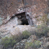
It sure feels good to be back in the nice, dry dessert. I decided to try to get to the mine that Lauren spotted back on August 8. After checking my pictures and using Google Earth, I decided where the mine must be and where a good place to park would be. It looked like the mine should be on the southeastern side of Horseshoe Mountain. Oh, you won't find Horseshoe Mountain on any maps, because I just made it up, because it doesn't seem to have a name on any map. It looks sort of like a horseshoe from certain angles, and I needed some way to refer to it. I should probably make a Google map with the names I've given to stuff out there.
On the way up Horseshoe Mountain, I came across the skeleton of a small animal that had lots of teeth. If anybody recognizes the jawbone, please let me know what kind of animal it was.
I kept looking for the mine on the way up and finally spotted it. It took me a little while to find a route up to it. It was pretty steep. I intentionally hiked to the ridge above the cave first and stood there enjoying the view and the breeze for a while.
By the time I got to the mine, it was close to sunset. I had to use the flash to get a picture of the inside of the mine, even though it was only about 8 feet deep. It went into the side of the rock, not down (much). Anyway, since I used the flash, some features are washed out. You can see a smaller notch cut into the back wall of the mine. What you can't see are about 7 holes drilled in various places in the back wall. Each was about 4 or 5 inches in diameter and 1 to 2 feet long. I don't know if they were exploratory or if they were where explosives were to be placed. Anyway, there was a snake curled up in one of the small holes. At the time, I couldn't tell what kind it was. Seeing the pits in the picture now, I'd say it's a rattler, maybe a black-tailed rattler.
What catches your eye about the mine from a distance is the squarish entrance. It looks out of place there and so it stands out. I turns out that the squareness is accidental. See that large rock on the floor of the mine? When it fell, it left a squared off notch at the top of the entrance.
The mine is very close to an area that is popular with litter bugs and other types of people that seem to want everybody else in the world to know when they've passed through an area. Trash of all sorts, shotgun shells, other gun shells, remnants of campfires, shot up saguaros, shot up rocks, and millions of pieces of broken bottles are scattered all along the eastern side of Horseshoe Mountain. Strangely, I could see no evidence that the neanderthals had made it up to the mine. There were no trails, there was no trash, and my footprints may be the only ones in the mine now. There is sort of a trail about a hundred feet south of the mine. You would never know the mine is there from that trail, though.
 |
| BC_2007_09 |


No comments:
Post a Comment