
I used the Wolverine Pass entrance. This is one of the entrances that I don't like to use because it's close to town, so all the knuckleheads use it.
When I got to the 60 degree, 40 foot climb with foot deep ruts and 1 foot diameter loose boulders, I was relieved to find that it wasn't near as bad as I remembered. The steep, rough part was only about as long as the truck and wasn't quite so steep that I needed to get out and use the come-along. I locked the axle and drove up. Uneventful. Thank goodness.

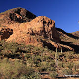
There are some very fine parking spots next to the Goldfield Mountains.
The road goes north and I followed it to where it makes a sharp turn east. It looks like it continues to the north, but that's not a valid road there. Driving on that part will get you a fine and loss of your BDC pass. Everybody else can get away with it, but I have a knack for doing the wrong thing while the cops are watching. Many years ago, I decided that I was tired of driving 55 and I wanted to get to Fort Stockton before the next day and I hadn't seen another car for about 2 hours, so I set the cruise control on 70, went over a hill, and got a ticket. But I digress.

Despite appearances to the contrary, this is NOT a road.
The plan was to hike north to the end of the "road" and see what was out there. In a nutshell, there are some pretty mountains out there. There was a low hill near the end of the "road". I was planning to continue on the road, but first I wanted to check out the view from the hill. As soon as I started climbing I saw a faint trail and decided to follow it since it was going the same direction I wanted to go. There were cairns along it. Hmm, maybe it goes somewhere besides the top of this little hill. It looked like a lot of feet may have walked along that trail, but they did it over many years. I think it has been more heavily traveled by animals than by people since the winter rains, at least. I followed it for as long as I dared; I wanted to get back to the "road" before sunset. It's not good to be in unfamiliar territory in the dark, especially when you are down to your last bottle of water. Silly me.

Every time I looked at this rock I heard it whisper softly, "Climb me. The view is fantastic. The breeze at my crest will give you goosebumps." I resisted its Siren call. This time.
From the trail, I couldn't tell where it was going. It looked like it might just continue up the canyon. After looking at maps, though, I'm hoping it goes up to a ridge dividing two canyons. I bet the view is incredible from up there. I don't know when it will be cool enough for me to go out there again, though.

The trail goes in that general direction.
Click below to see all of the pictures.
 |
| 2010_07_05 |


No comments:
Post a Comment