
Exploratory well. I don't think they're looking for petroleum. I saw 2 rigs drilling and evidence of previously drilled wells.
It was too hot in the valley (over 110) to do anything close to home. The altitude where I was going is only around 4000 feet but that's enough to reduce the temperature to a tolerable level. It was in the upper 90's where I started my hike. The humidity is way up, though. I had sweat trickling down my temples after a short leisurely stroll down a mild incline, and I was looking for places to get out of the sun.
Before I got out of the truck, I was driving down the road that goes past the Apache Leap trail. I got to an uphill stretch that I hadn't been able to drive up in the past. The tires just spun. I was able to drive up it without any trouble this time, though. Hooray for Michelin tires! It's always cool to finally go over the top of a ridge that you've only looked up at several times before, and finally see what's on the other side.

Finally, at the top of the next ridge. The road in the background was too rough for my liking, so I didn't go that way.
I decided to continue along the road as far as I could. The road split near the stock tank in the previous picture. I took the left fork because the right fork looked rougher that what I wanted to drive on. Well, the left fork was just as rough, but I couldn't see that part at first. It was one vehicle wide. It would be impossible to turn around. It kept getting steeper and rougher. I was afraid I might have to back all the way down. I was just hoping that I would find a place to turn around and get out of there before I encountered somebody going the other direction. It turns out that that section of road is only a quarter mile long, is a dead end with a lot of room to turn around, and I was the only person to drive on it since the last rain (maybe a day or two earlier). When I got to the top, I decided that would be a good place to hike around a little and get some pictures.

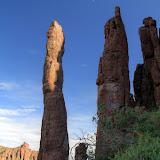
If you like hoodoos, this is your place.

This looks like it's a popular spot for people to visit.

It's the time of year for agave flowers.
I was wandering along mostly aimlessly taking pictures of rocks and plants when I noticed a faint trail and a cairn. It headed into the canyon to the east. There were large trees at the bottom of the canyon and I thought I could hear a waterfall. Maybe the trail ends at a pool of cool water and I can go swimming.

Rock columns visible from the trail.

Looking across the canyon. Notice how green the bottom is.

Rocks.
As the trail descended, it also headed towards a stone column. At first I thought that was coincidental.

The trail is heading towards the base of the column on the left

The view above me.

At the stone column. I'm guessing that it's about 50 feet tall.
When I got to the base of the stone column, the trail just ended. That seemed really strange. Why come out here and just stop? It looked like a fair amount of people had been out here since spring. They had trampled the grass. They had hacked through bushes. They had built cairns. I looked more closely at the column and thought I could see why they had been there. I zoomed in with the camera and confirmed my suspicion.

I don't know the technical names of climbing gear, but there's a metal ring attached to the rock. People come out here to climb this column.

An HDRI of the columns and the moon.
I guess the rock climbers don't climb this time of year. That column would not be a good place to be during a thunderstorm. Click below to see all of the pictures.
 |
| 2010_07_17 |


No comments:
Post a Comment