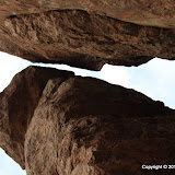
My goal seems far away and high above me.
The old road enabled me to move very quickly toward my destination. In fact, I was walking so fast I missed a lot of things. I saw them on the way back, or hints of them, but it was too dark for pictures by then.
The sky was a mixture of pretty and ugly clouds.
One cool thing about being up high is seeing all the other places I've been.
I could tell that I was approaching the end of the wide part of the trail when I encountered a couple coming the other way. I asked them where the trail went and they said that in about 10 minutes I would come to a lot of boulders that I would have to climb over. That's where they had turned around. I didn't want to climb over boulders, so I was hopeful that I would find a way around.
The couple I encountered is in the lower left corner of this picture. I didn't mean to get them in the picture, so that's why they are hard to see.
A couple of minutes later the trail became a narrow foot path that twisted this way and that. It was marked with cairns along this part. It's the kind of trail that is easy to loose if you don't keep looking to your left and right. I think that must be what happened to that couple. They thought they were following the trail but ended up in the bed of a wash. I never encountered any boulders that I had to scramble over.

This lovely arrangement is very close to the pinnacles.
I was elated when I stepped on the the bare rock that forms the base of the pinnacles, but not so elated that I forgot to take careful note of where I was, so I would be able to find the easy way back. I spent about 45 minutes wandering around up there taking in the sights and taking pictures.
I hung out there long enough that I knew it would be dark before I got back to the truck. I just wanted to make it to the straight part of the trail before it got dark, and I did that with no problem. It was a much longer hike than I've been on for a few months, so I welcomed the chance to stop and take sunset pictures on the way back.
I spent 2 or 3 days wandering around out there looking for a route to those pinnacles, then on the day I hiked all the way too them, I took a route I found looking at Google Earth. Well, I had fun wandering around those 2 or 3 days, so that wasn't wasted effort. In fact, my primary objective on those days was to wander around in the desert. Finding a route was secondary. You never know what you'll come across just wandering around off the beaten trail. Click below to see all of the pictures.
 |
| 2010_10_17 |
P.S. I've had my SPOT satellite messenger for a year and 10 or 11 months. I finally had to change the batteries. That's pretty amazing for a GPS receiver that also transmits my position to an LEO satellite 3 times every ten minutes.


1 comment:
I've found all kinds of stuff using google earth that i wouldn't otherwise have known about. I love that program!
Post a Comment