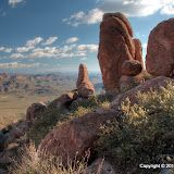
There were fewer clouds on Sunday.
I remembered that the trail kept getting steeper as it approached the halfway point, but I had forgotten just how steep. I stopped a lot on the way up to catch my breath. Being out of breath doesn't bother me as much as thinking about how difficult it will be going back down the same way. It was a little nerve wracking going down the bare rock portions with water on them.

My destination is on top of those hoodoos.
The steep part of the hike was in the shade, and there was a cool, light breeze. Of course, I was sweating, so I was freezing by the time I got to my destination and back in the sunshine. I had thought about going further along the trail, but I just wanted to get back to my warm truck. I put on a flannel shirt but still thought it was too cold to be hiking. Gee, sounds like I'm almost too old for this already.
My GPS data logger couldn't track enough satellites to navigate near the top of the hike, so pictures I took up there aren't quite correctly geotagged. When the weather warms up, I may try to get to the top of the trail. Actually, I'll probably say it's too hot. Click here to see the EveryTrail map. Click below to see all of the pictures.
 |
| 2010_01_24 |


No comments:
Post a Comment