So then I thought that I should take the ATV out to Bulldog Canyon and drive down some roads I hadn't been on in a few years. I hooked it up to the charger on Sunday morning. It was charged after lunch and I tried to start it. And tried and tried. Then I gave up.
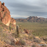
I loaded my camera and backpack into the truck and headed out, wondering where I was going. I wanted to go someplace different. I couldn't think of someplace completely different that was nearby, so I drove down Peralta road thinking that I would stop somewhere along there or maybe even hike on a trail at the end of the road. I wound up stopping where the road that used to go out to the Carney Springs trail was. The road is closed now (long, sad story) and I haven't been out that direction since it closed. I figured I could walk where the road used to go and see how long of a walk it is. It turned out to not be as bad as I was afraid it would be. I got to the Carney Springs trail and started along it, still thinking that I wanted to see something different.

This is where the road used to be. It's been dug up, and there have even been a few cacti stuck in the dirt (that's all it takes to get them growing).
The Carney Springs trail gets to a spot where it looks like there may have been a concrete water trough at one time. There are only a few pieces visible in the dirt now. I was looking around in that area when I noticed a side trail heading east. Cool, something new! Of course, I followed it. It went a few yards and became hard to follow. Then after a few more yards it crossed a small wash. Then it all but disappeared. A fair amount of people had to have gone this way, though, so I was determined to follow it whether I could see it or not. So I started going uphill, because that's a direction I often like to go, and downhill didn't look interesting. Somebody that had been on the "trail" recently couldn't be bothered to step over plants in the path, so I was able to follow a trail of smashed brittlebush, smashed fairy dusters, and displaced rocks. The smasher didn't step on any cholla, though.

Somebody left a trail marker that turned out to be a Planet Hollywood windbreaker from Paris. I kept it.
Since I was in an area that was new to me and because it would be easy to lose the trail, I was stopping frequently to look around. On one of those stops I spotted a cave. I thought that must be the trail's destination, and it did go there.

A cave.

On the inside looking out. Gee, writing that took me back to the mid-60's. The Animals. Wasn't a big hit in the colonies.
After looking around in the cave (not much to see), I went up on the rocks on top of it. The view was much better up there. From up there I thought I could see some mine tailings. I knew there was a mine up there somewhere, but I didn't know where. I thought I had found it. Stomper had gone in that direction, too, so maybe I was on to something.

One of the views from above the cave. Find the truck!
As it turned out, what looked like tailings from a distance was actually solid rock. I walked across to the other side. The "trail" continued beyond there but the slope it was on got too steep for me. I didn't want to descend doing cartwheels through cacti. I headed back down the slow way.
My GPS data logger did pretty good until I got up on the side of the mountains. I'm convinced that it's the terrain in which I hike that's causing all the problems. Well, that's not gonna change (I hope).
The GPS track looked good on the @trip map, but when I uploaded it to EveryTrail, it looked like I flew back and forth across a canyon at 85 mph. Wow, I wish I could really do that! The @trip software must filter out stuff like that. EveryTrail allows you to edit the track, so I moved a couple of track points over to the correct side of the canyon. There's still some screwy stuff in the data. I'm doing this for fun, though, so I'm done worrying about it.
Click here for the EveryTrail map and below for all of the pictures.
 |
| 2010_01_10 |


No comments:
Post a Comment