Anyway, I left the house kind of late yesterday. I thought that since it was late and since it had been overcast all day, maybe there wouldn't be many people going to the Renaissance Fair to the east of Gold Canyon. I might be able to get to Superior without too much trouble, and then to White Canyon. The only trouble I had was finding Battle Axe Road. I drove by it a couple of times and glanced at the sign there and thought it said "PRIVATE ROAD", but actually it said "PRIMITIVE ROAD". I finally figured that out and headed down the road. It was in very good shape for a primitive road until I got a little ways past the right turn at the corral. High clearance became necessary and 4wd or locking rear axle highly desirable. Even then, much of the "road" was nice and smooth as it followed a wash. I soon got to places that would have had me stuck if I couldn't have locked the axle. I think the road used to follow the wash through an area that had been washed out (ha ha), leaving nothing but large boulders in the path. Since then, it looks like people have created a route around the washed-out part (still in the bed of the wash). I had to lock the axle to get on and off the alternate route, in both directions. If I wasn't so lazy, I could have made that easier by moving some small boulders to the side. Maybe next time I'm out there. Or maybe they'll get washed away with today's rain. Anyway, that's enough of this wash stuff.

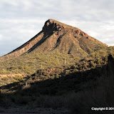
Battle Axe Road heads for Copper Butte. This is Copper Butte from the side; didn't want a picture of it shooting into the sun.
I drove along the road until I got to a fence. There is a gate, but I turned around there because it was getting late and the road was downhill and steep on the other side. I didn't want to be stuck down there after sunset.

Cottonwoods along the way.

Now that's a spring. Wonder what it looks like in July.

Impressive cliffs all around.

That cliff is pictured in a lot of descriptions of this area.
The area is beautiful. I didn't get to see much of it, though, and I didn't get any good pictures. I will definitely be going back. I would be there now if it wasn't raining. Click here to see the EveryTrail map. Click below to see all of the pictures.
 |
| WC_2010_02_27 |


No comments:
Post a Comment