
I'm going in this direction.
When Gary and I were out here a couple of weeks ago, we were looking at some mountains and talking about how it looked like a person would be able to find a couple of routes to the top, but you can't really tell until you go up there and try it. I went to that place. As I approached the mountains, I stopped now and then and looked at the possible routes and planned where I would go. Unfortunately, when you get closer, you can't really tell where you are in relation to where you wanted to be, and you can rarely see more than 100 feet beyond where you are. That applies to looking both uphill and downhill. Looking downhill is scary because it looks very steep. You can see where you might descend safely for 30 or 40 feet, but beyond that it looks impossible. You just have to go that 30 or 40 feet and hope you see something else from there. Since I had just gone up there, though, I remembered most of the route down. Even if I don't remember the exact route in situations like this, I find that I usually retrace my steps because finding the best route down is just a mirror of finding the best route up.

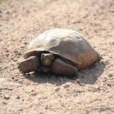
I saw a desert tortoise at the beginning of the hike. This is a small one.

There are lots of flowers. These are blue lupines.

Desert marigold.

Brittlebush.
I eventually got to a point where it didn't look safe to go any higher, at least not in the direction I was going. Also, I was getting tired. I sat down to relax and eat snacks for a while. I took off my shirt to work on my tan and a hummingbird came to check me out. I guess I looked like a big, white flower.
When I downloaded the data from my GPS data logger, the @trip PC software removed some of the data points. It must have some algorithm for deciding what data is wrong and then deleting it. It did the same thing to the data from my last hike, and it deleted all the data from when I left the trail, which was where I took most of my pictures. It has no knowledge of trails, so that can't be it. Maybe it deletes data with large elevation changes in a short distance. Anyway, I had to export the data to a GPX file and use Microsoft's Pro Photo Tools (a free download) to geotag the pictures. Several were still incorrectly located. I think the data logger wasn't getting a fix, which is hard to believe since it had visibility of at least 50% of the sky. I'm starting to wonder if it is flaking out when it gets warm. I guess I'll know if that's it when the weather really warms up.
Click below to see all of the pictures.
 |
| BC_2010_04_10 |


No comments:
Post a Comment